
Magnitude |
3.4 |
| Date & Time (UTC) | 2025-07-27 09:16:14.6 |
| Date & Time (Local) | 1404/5/5 12:46:14.6 |
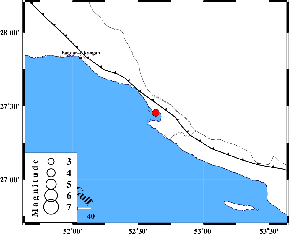
| Location | Lat:27.454 Lon: 52.635 |
| Region | , 27 km -West of Mehr |
Nearest Cities |
|
| 3 km of Bandar-e asaluyeh, Bushehr Province | |
| 18 km North West of Chah-e mobarak, Bushehr Province | |
| 22 km South West of Ardavan-e olia, Fars Province | |
| 23 km South of Gallehdar, Fars Province | |
| 27 km West of Mehr, Fars Province | |
| Depth | 12 km |
| Agency | |
Faults within 150 km: |
|
| MFF3 (Length: 292 km) , Distance to epicenter: 15 km | |
| QIR_F (Length: 130 km) , Distance to epicenter: 110 km | |
| BORAZJAN_F (Length: 168 km) , Distance to epicenter: 120 km | |
| Number of Phases | 10 |
| RMS | 0.5 |
| Number of Stations | 10 |
| Error in Latitude | >3.2 km |
| Error in Longitude | 3.2 km |
| Error in Depth | 696.9 km |
Download waveform in seisan format
to download seisan software Click here
to access information about IIEES stations Click here
Amplitude | ||||||||
| UID | Agency | Station | Component | Amplitude | Period | Arrival Time | Proccessing Time | Signal Clip |
| 199410 | IIEES SC | UOSS | Z | 0.04 | 1 | 2025-07-27 09:17:18 | 2025-10-01 07:07:00 | n |
| 199411 | IIEES SC | TABS | Z | 0.009 | 1 | 2025-07-27 09:18:03 | 2025-10-01 07:07:00 | n |
| 199412 | IIEES SC | IRSR | Z | 0.01 | 1 | 2025-07-27 09:18:05 | 2025-10-01 07:07:00 | n |
Phase | ||||||||||||
| Agency | Station | Component | Phase Type | Phase Quality | First Motion | Observed Arrival Time | Time Residual | Loc. Flag | Input Weight | Distance | Azimuth | |
| IIEES SC | GHIR | Z | EPg | E | 2025-07-27 09:16:36 | 4.5 | n | 4 | 98 | 21 | ||
| IIEES SC | UOSS | Z | EPn | E | 2025-07-27 09:17:18 | -0.2 | y | 0 | 452 | 128 | ||
| IIEES SC | KRBR | Z | EPn | E | 2025-07-27 09:17:23 | -0.5 | y | 0 | 491 | 55 | ||
| IIEES SC | YZKH | Z | EPn | E | 2025-07-27 09:17:08 | -25.9 | n | 4 | 579 | 19 | ||
| IIEES SC | NASN | Z | EPn | E | 2025-07-27 09:17:36 | 0 | y | 0 | 593 | 2 | ||
| IIEES SC | TABS | Z | EPn | E | 2025-07-27 09:18:03 | 0.2 | y | 0 | 810 | 32 | ||
| IIEES SC | IRSR | Z | EPn | E | 2025-07-27 09:18:05 | 1.6 | y | 0 | 817 | 94 | ||
| IIEES SC | RAYN | Z | EPn | E | 2025-07-27 09:18:06 | -0.1 | y | 0 | 839 | 239 | ||
| IIEES SC | DAMV | Z | EPn | E | 2025-07-27 09:18:11 | -4.1 | n | 4 | 909 | 356 | ||
| IIEES SC | SRSL | Z | EPn | E | 2025-07-27 09:18:50 | 0.1 | y | 0 | 1186 | 325 | ||