
Magnitude |
3.1 |
| Date & Time (UTC) | 2025-11-05 00:46:27.1 |
| Date & Time (Local) | 1404/8/14 04:16:27.1 |
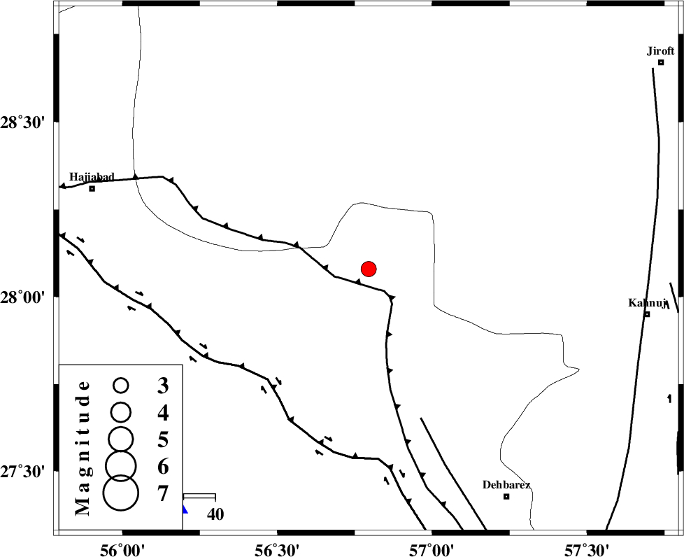
| Location | Lat:28.08 Lon: 56.795 |
| Region | Hormozgan Province, 89 km North-West of Kahnuj |
Nearest Cities |
|
| 30 km South of Sarkhan, Kerman Province | |
| 47 km North West of Faryab, Kerman Province | |
| 53 km South West of Hurpasefid, Kerman Province | |
| 56 km North East of Fareqan, Hormozgan Province | |
| 56 km North West of Fariab, Hormozgan Province | |
| Depth | 17 km |
| Agency | |
Faults within 150 km: |
|
| MAIN_ZAGROS_R_F (Length: 1106 km) , Distance to epicenter: 5 km | |
| HZF2 (Length: 437 km) , Distance to epicenter: 48 km | |
| ZENDAN_MINAB_F_Z1 (Length: 183 km) , Distance to epicenter: 50 km | |
| Number of Phases | 8 |
| RMS | 0.3 |
| Number of Stations | 8 |
| Error in Latitude | >2.1 km |
| Error in Longitude | 2.1 km |
| Error in Depth | 460.3 km |
Download waveform in seisan format
to download seisan software Click here
to access information about IIEES stations Click here
Amplitude | ||||||||
| UID | Agency | Station | Component | Amplitude | Period | Arrival Time | Proccessing Time | Signal Clip |
| 199965 | IIEES SC | UOSS | Z | 0.03 | 1 | 2025-11-05 00:47:18 | 2025-11-05 07:54:00 | n |
| 199966 | IIEES SC | TABS | Z | 0.02 | 1 | 2025-11-05 00:47:51 | 2025-11-05 07:54:00 | n |
| 199967 | IIEES SC | SHRT | Z | 0.02 | 1 | 2025-11-05 00:48:00 | 2025-11-05 07:54:00 | n |
Phase | ||||||||||||
| Agency | Station | Component | Phase Type | Phase Quality | First Motion | Observed Arrival Time | Time Residual | Loc. Flag | Input Weight | Distance | Azimuth | |
| IIEES SC | KRBR | Z | EPn | E | 2025-11-05 00:47:01 | 1 | y | 0 | 211 | 359 | ||
| IIEES SC | UOSS | Z | EPn | E | 2025-11-05 00:47:18 | 0 | y | 0 | 352 | 190 | ||
| IIEES SC | GHIR | Z | EPn | E | 2025-11-05 00:47:21 | 0 | y | 0 | 375 | 273 | ||
| IIEES SC | IRSR | Z | EPn | E | 2025-11-05 00:47:26 | 0 | y | 0 | 420 | 107 | ||
| IIEES SC | MEH | Z | EPn | E | 2025-11-05 00:47:26 | -0.6 | y | 0 | 423 | 330 | ||
| IIEES SC | BSRN | Z | EPn | E | 2025-11-05 00:47:47 | 12.2 | n | 4 | 486 | 28 | ||
| IIEES SC | TABS | Z | EPn | E | 2025-11-05 00:47:51 | 0.5 | y | 0 | 618 | 3 | ||
| IIEES SC | SHRT | Z | EPn | E | 2025-11-05 00:48:00 | -0.9 | y | 0 | 702 | 28 | ||