
Magnitude |
2.8 |
| Date & Time (UTC) | 2006-12-23 11:57:45.0 |
| Date & Time (Local) | 1385/10/2 15:27:45.0 |
| Location | Lat:36.02 Lon: 53.82 |
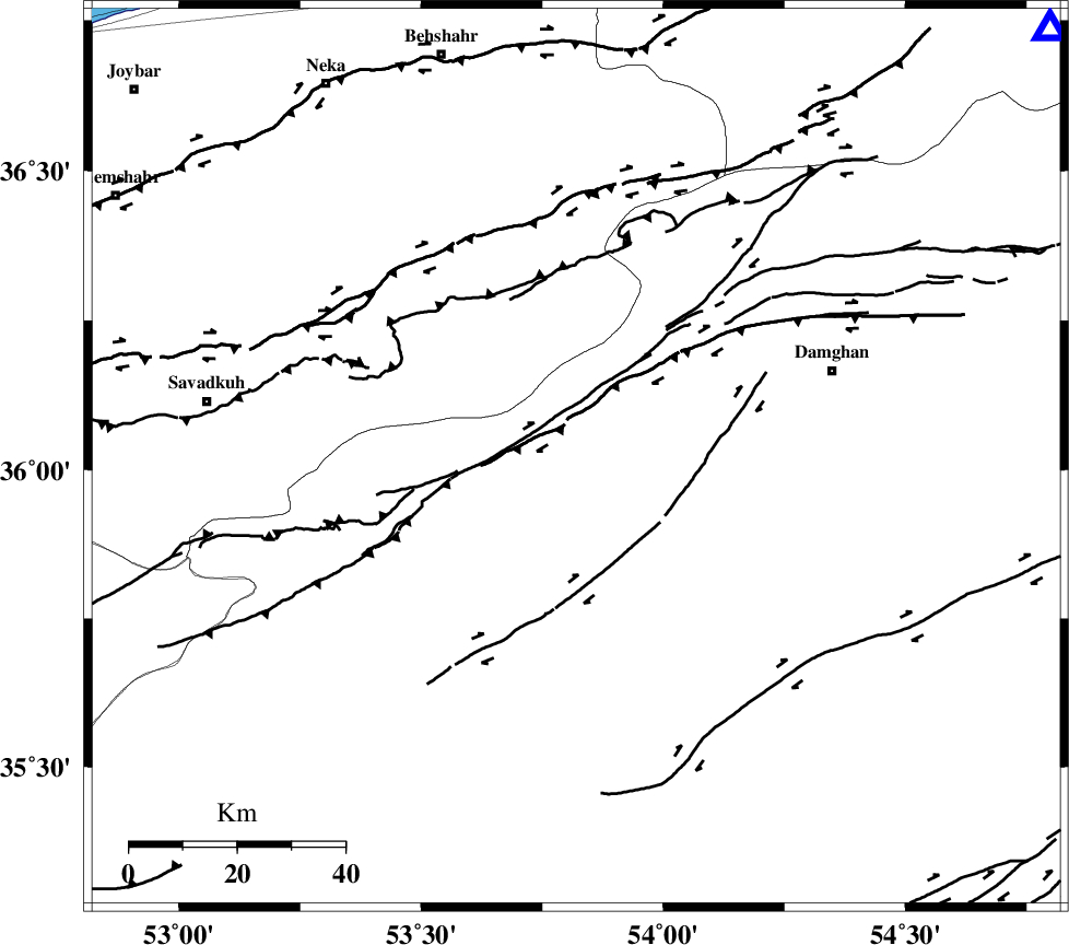
| Region | 50 km South-West of Damghan, Semnan Province |
Nearest Cities |
|
| 9 km North of Darvar, Semnan Province | |
| 24 km South East of Talma darreh, Mazandaran Province | |
| 30 km West of Amirabad, Semnan Province | |
| 30 km West of Seydabad, Semnan Province | |
| 35 km South East of Kiasar, Mazandaran Province | |
| Depth | 15 km |
| Agency | |
Faults within 150 km: |
|
| DAMGHAN_F (Length: 95 km) , Distance to epicenter: 14 km | |
| ATARI_F (Length: 185 km) , Distance to epicenter: 14 km | |
| ASTANEH_F (Length: 72 km) , Distance to epicenter: 29 km | |
| Number of Phases | 5 |
| RMS | 0.1 |
| Number of Stations | 5 |
| Error in Latitude | >2.9 km |
| Error in Longitude | 2.8 km |
| Error in Depth | 999.9 km |
Download waveform in seisan format
to download seisan software Click here
to access information about IIEES stations Click here
Amplitude | ||||||||
| UID | Agency | Station | Component | Amplitude | Period | Arrival Time | Proccessing Time | Signal Clip |
| 37041 | IIEES | THKV | E | 95.2 | 0.52 | 2006-12-23 11:59:07 | 2007-01-07 07:24:00 | n |
| 37042 | IIEES | THKV | N | 72.1 | 0.86 | 2006-12-23 11:59:09 | 2007-01-07 07:24:00 | n |
| 37043 | IIEES | NASN | E | 12.4 | 0.43 | 2006-12-23 11:59:47 | 2007-01-07 07:24:00 | n |
| 37044 | IIEES | ASAO | N | 12.6 | 0.73 | 2006-12-23 11:59:41 | 2007-01-07 07:24:00 | n |
Phase | ||||||||||||
| Agency | Station | Component | Phase Type | Phase Quality | First Motion | Observed Arrival Time | Time Residual | Loc. Flag | Input Weight | Distance | Azimuth | |
| IIEES | CHTH | Z | Pn | E | 2006-12-23 11:58:23 | 0.1 | y | 244 | 268 | |||
| IIEES | THKV | Z | Pn | E | 2006-12-23 11:58:25 | -0.1 | y | 266 | 268 | |||
| IIEES | MRVT | Z | Pn | E | 2006-12-23 11:58:26 | 0 | y | 272 | 47 | |||
| IIEES | NASN | Z | Pn | E | 2006-12-23 11:58:38 | 0 | y | 369 | 195 | |||
| IIEES | ASAO | Z | Pn | E | 2006-12-23 11:58:40 | 0 | y | 382 | 246 | |||