
Magnitude |
2.5 |
| Date & Time (UTC) | 2007-03-14 22:23:20.4 |
| Date & Time (Local) | 1385/12/24 01:53:20.4 |
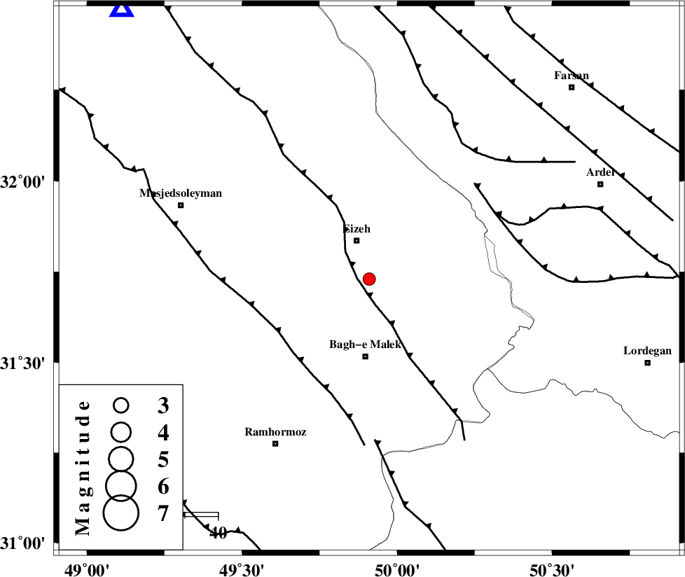
| Location | Lat:31.73 Lon: 49.91 |
| Region | 12 km South of Izeh, Khoozestan Province |
Nearest Cities |
|
| 11 km North of Ghaleh tal, Khoozestan Province | |
| 12 km South of Izeh, Khoozestan Province | |
| 14 km East of Chenarestan, Khoozestan Province | |
| 18 km South of Rasvand, Khoozestan Province | |
| 21 km North of Abolabbas, Khoozestan Province | |
| Depth | 29 km |
| Agency | |
Faults within 150 km: |
|
| MFF2 (Length: 205 km) , Distance to epicenter: 4 km | |
| DEZFUL_EMBAYMENT (Length: 228 km) , Distance to epicenter: 32 km | |
| SABZKUH_F (Length: 67 km) , Distance to epicenter: 43 km | |
| Number of Phases | 7 |
| RMS | 0.4 |
| Number of Stations | 5 |
| Error in Latitude | >8.6 km |
| Error in Longitude | 8.7 km |
| Error in Depth | 14.9 km |
Download waveform in seisan format
to download seisan software Click here
to access information about IIEES stations Click here
Amplitude | ||||||||
| UID | Agency | Station | Component | Amplitude | Period | Arrival Time | Proccessing Time | Signal Clip |
| 37597 | IIEES | SHGR | N | 238.6 | 0.36 | 2007-03-14 22:23:56 | 2007-04-22 03:28:00 | n |
| 37598 | IIEES | SHGR | E | 167 | 0.32 | 2007-03-14 22:23:56 | 2007-04-22 03:28:00 | n |
| 37599 | IIEES | ASAO | N | 8.9 | 0.72 | 2007-03-14 22:24:58 | 2007-04-22 03:28:00 | n |
| 37600 | IIEES | ASAO | E | 7.9 | 0.44 | 2007-03-14 22:24:59 | 2007-04-22 03:28:00 | n |
Phase | ||||||||||||
| Agency | Station | Component | Phase Type | Phase Quality | First Motion | Observed Arrival Time | Time Residual | Loc. Flag | Input Weight | Distance | Azimuth | |
| IIEES | SHGR | Z | Pg | E | 2007-03-14 22:23:38 | -0.3 | y | 113 | 292 | |||
| IIEES | SHGR | E | Sg | E | 2007-03-14 22:23:53 | 0.4 | y | 113 | 292 | |||
| IIEES | NASN | Z | Pn | E | 2007-03-14 22:24:04 | 0.1 | y | 298 | 66 | |||
| IIEES | ASAO | Z | Pn | E | 2007-03-14 22:24:06 | 0.6 | y | 313 | 2 | |||
| IIEES | ASAO | N | Sg | E | 2007-03-14 22:24:46 | -0.1 | y | 313 | 2 | |||
| IIEES | GHVR | Z | Pn | E | 2007-03-14 22:24:07 | -0.1 | y | 330 | 22 | |||
| IIEES | SNGE | Z | Pn | E | 2007-03-14 22:24:21 | -0.7 | y | 443 | 328 | |||