
Magnitude |
2.5 |
| Date & Time (UTC) | 2007-03-25 14:17:34.3 |
| Date & Time (Local) | 1386/1/5 17:47:34.3 |
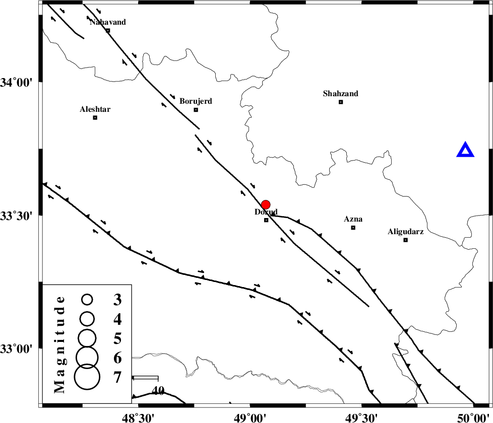
| Location | Lat:33.54 Lon: 49.07 |
| Region | 6 km Dorud, Lorestan Province |
Nearest Cities |
|
| 6 km of Zhan, Lorestan Province | |
| 6 km North of Dorud, Lorestan Province | |
| 9 km North of Void, Lorestan Province | |
| 13 km East of Kagheh, Lorestan Province | |
| 14 km North West of Heshmatabad, Lorestan Province | |
| Depth | 14 km |
| Agency | |
Faults within 150 km: |
|
| MAIN_ZAGROS_R_F (Length: 1106 km) , Distance to epicenter: 5 km | |
| DORUD (Length: 100 km) , Distance to epicenter: 5 km | |
| HZF4 (Length: 492 km) , Distance to epicenter: 36 km | |
| Number of Phases | 6 |
| RMS | 0.1 |
| Number of Stations | 4 |
| Error in Latitude | >2.7 km |
| Error in Longitude | 4.6 km |
| Error in Depth | 9.7 km |
Download waveform in seisan format
to download seisan software Click here
to access information about IIEES stations Click here
Amplitude | ||||||||
| UID | Agency | Station | Component | Amplitude | Period | Arrival Time | Proccessing Time | Signal Clip |
| 37653 | IIEES | ASAO | E | 41.1 | 0.36 | 2007-03-25 14:18:21 | 2007-04-22 03:28:00 | n |
| 37654 | IIEES | SHGR | E | 42 | 0.44 | 2007-03-25 14:18:26 | 2007-04-22 03:28:00 | n |
| 37655 | IIEES | SHGR | N | 32.7 | 0.32 | 2007-03-25 14:18:31 | 2007-04-22 03:28:00 | n |
| 37656 | IIEES | GHVR | N | 200.9 | 0.48 | 2007-03-25 14:18:51 | 2007-04-22 03:28:00 | n |
Phase | ||||||||||||
| Agency | Station | Component | Phase Type | Phase Quality | First Motion | Observed Arrival Time | Time Residual | Loc. Flag | Input Weight | Distance | Azimuth | |
| IIEES | ASAO | Z | Pg | E | 2007-03-25 14:17:58 | 0 | y | 142 | 38 | |||
| IIEES | ASAO | E | Sg | E | 2007-03-25 14:18:15 | -0.2 | y | 142 | 38 | |||
| IIEES | SHGR | Z | Pg | E | 2007-03-25 14:18:00 | -0.1 | y | 161 | 189 | |||
| IIEES | GHVR | Z | Pg | E | 2007-03-25 14:18:11 | 0 | y | 226 | 62 | |||
| IIEES | GHVR | N | Sg | E | 2007-03-25 14:18:38 | 0.1 | y | 226 | 62 | |||
| IIEES | SNGE | Z | Pn | E | 2007-03-25 14:18:11 | 0.1 | y | 234 | 318 | |||