
Magnitude |
2.9 |
| Date & Time (UTC) | 2007-06-25 22:52:19.5 |
| Date & Time (Local) | 1386/4/5 02:22:19.5 |
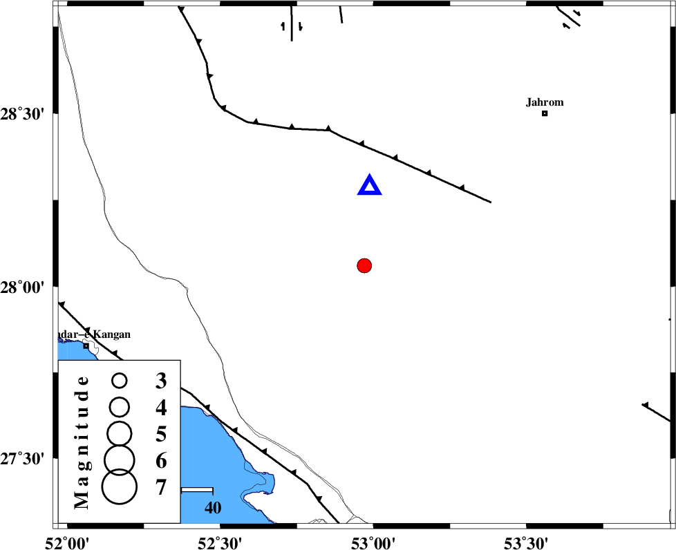
| Location | Lat:28.06 Lon: 52.97 |
| Region | 45 km South of Qir va Karzin, Fars Province |
Nearest Cities |
|
| 21 km South West of Seyfabad, Fars Province | |
| 25 km North East of Garmesht, Fars Province | |
| 41 km South West of Shahrak-e jonubi, Fars Province | |
| 45 km South of Qir va Karzin, Fars Province | |
| 46 km South East of Hengam, Fars Province | |
| Depth | 14 km |
| Agency | |
Faults within 150 km: |
|
| QIR_F (Length: 130 km) , Distance to epicenter: 36 km | |
| MFF3 (Length: 292 km) , Distance to epicenter: 68 km | |
| SABZ_PUSHAN_F_Z1 (Length: 69 km) , Distance to epicenter: 76 km | |
| Number of Phases | 5 |
| RMS | 0 |
| Number of Stations | 3 |
| Error in Latitude | >3.9 km |
| Error in Longitude | 4.2 km |
| Error in Depth | 3.4 km |
Download waveform in seisan format
to download seisan software Click here
to access information about IIEES stations Click here
Amplitude | ||||||||
| UID | Agency | Station | Component | Amplitude | Period | Arrival Time | Proccessing Time | Signal Clip |
| 38584 | IIEES | GHIR | E | 1866.4 | 0.48 | 2007-06-25 22:52:36 | 2007-07-30 02:44:00 | n |
| 38585 | IIEES | GHIR | N | 1898.3 | 0.52 | 2007-06-25 22:52:37 | 2007-07-30 02:44:00 | n |
| 38586 | IIEES | BNDS | N | 37.1 | 0.6 | 2007-06-25 22:54:06 | 2007-07-30 02:44:00 | n |
| 38587 | IIEES | KRBR | N | 31.9 | 0.56 | 2007-06-25 22:54:29 | 2007-07-30 02:44:00 | n |
| 38588 | IIEES | KRBR | E | 19.9 | 0.8 | 2007-06-25 22:54:32 | 2007-07-30 02:44:00 | n |
Phase | ||||||||||||
| Agency | Station | Component | Phase Type | Phase Quality | First Motion | Observed Arrival Time | Time Residual | Loc. Flag | Input Weight | Distance | Azimuth | |
| IIEES | GHIR | Z | Pg | E | 2007-06-25 22:52:24 | 0 | y | 25.4 | 4 | |||
| IIEES | GHIR | N | Sg | E | 2007-06-25 22:52:28 | 0 | y | 25.4 | 4 | |||
| IIEES | BNDS | Z | Pn | E | 2007-06-25 22:53:07 | 0 | y | 324 | 102 | |||
| IIEES | BNDS | N | Sg | E | 2007-06-25 22:53:50 | 0 | y | 324 | 102 | |||
| IIEES | KRBR | Z | Pn | E | 2007-06-25 22:53:20 | 0 | y | 426 | 59 | |||