
Magnitude |
3.3 |
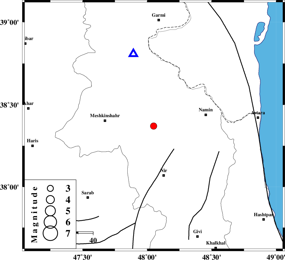
| Date & Time (UTC) | 2007-11-18 21:42:49.5 |
| Date & Time (Local) | 1386/8/28 01:12:49.5 |
| Location | Lat:38.37 Lon: 48.05 |
| Region | 25 km North-West of Ardabil, Ardebil Province |
Nearest Cities |
|
| 5 km North of Samarin, Ardebil Province | |
| 11 km North of Khoshkehrud, Ardebil Province | |
| 16 km North of Sardabeh, Ardebil Province | |
| 19 km North West of Ardimusa, Ardebil Province | |
| 21 km South East of Fakhrabad, Ardebil Province | |
| Depth | 36 km |
| Agency | |
Faults within 150 km: |
|
| BOZQUSH (Length: 70 km) , Distance to epicenter: 21 km | |
| SANGAVAR_F (Length: 61 km) , Distance to epicenter: 47 km | |
| TALESH_F (Length: 258 km) , Distance to epicenter: 70 km | |
| Number of Phases | 7 |
| RMS | 0.1 |
| Number of Stations | 6 |
| Error in Latitude | >1.7 km |
| Error in Longitude | 4 km |
| Error in Depth | 2.8 km |
Download waveform in seisan format
to download seisan software Click here
to access information about IIEES stations Click here
Amplitude | ||||||||
| UID | Agency | Station | Component | Amplitude | Period | Arrival Time | Proccessing Time | Signal Clip |
| 40143 | IIEES | ZNJK | E | 338.3 | 0.64 | 2007-11-18 21:43:47 | 2008-04-12 10:47:00 | n |
| 40144 | IIEES | ZNJK | N | 240 | 0.14 | 2007-11-18 21:43:47 | 2008-04-12 10:47:00 | n |
| 40145 | IIEES | THKV | E | 76.8 | 0.36 | 2007-11-18 21:44:25 | 2008-04-12 10:47:00 | n |
| 40146 | IIEES | THKV | N | 67 | 0.6 | 2007-11-18 21:44:35 | 2008-04-12 10:47:00 | n |
Phase | ||||||||||||
| Agency | Station | Component | Phase Type | Phase Quality | First Motion | Observed Arrival Time | Time Residual | Loc. Flag | Input Weight | Distance | Azimuth | |
| IIEES | GRMI | Z | Pg | E | 2007-11-18 21:42:59 | 0 | y | 50.5 | 344 | |||
| IIEES | GRMI | E | Sg | E | 2007-11-18 21:43:07 | 0 | y | 50.5 | 344 | |||
| IIEES | ZNJK | Z | Pg | E | 2007-11-18 21:43:21 | 0 | y | 197 | 163 | |||
| IIEES | SNGE | Z | Pn | E | 2007-11-18 21:43:41 | 0 | y | 369 | 190 | |||
| IIEES | THKV | Z | Pn | E | 2007-11-18 21:43:41 | 0.1 | y | 371 | 136 | |||
| IIEES | CHTH | Z | Pn | E | 2007-11-18 21:43:43 | 0 | y | 386 | 134 | |||
| IIEES | MRVT | Z | Pn | E | 2007-11-18 21:44:23 | -0.1 | y | 710 | 94 | |||