
Magnitude |
2.8 |
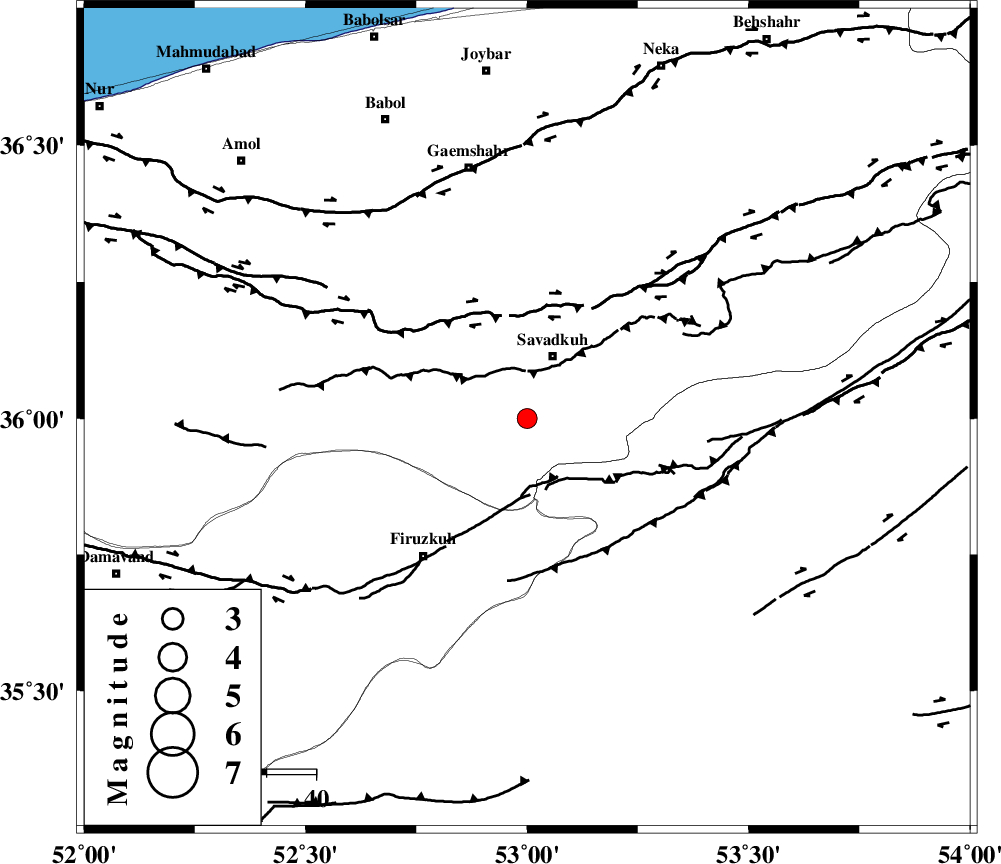
| Date & Time (UTC) | 2007-11-22 16:13:49.3 |
| Date & Time (Local) | 1386/9/1 19:43:49.3 |
| Location | Lat:36 Lon: 53 |
| Region | 14 km South of Pol-E-Sefid, Mazandaran Province |
Nearest Cities |
|
| 10 km of Elahband, Mazandaran Province | |
| 11 km of Shurmast-e peyrudbar, Mazandaran Province | |
| 14 km South of Pol-E-Sefid, Mazandaran Province | |
| 17 km East of Alasht, Mazandaran Province | |
| 19 km South of Zirab, Mazandaran Province | |
| Depth | 14 km |
| Agency | |
Faults within 150 km: |
|
| N_ALBORZ_F (Length: 360 km) , Distance to epicenter: 22 km | |
| ATARI_F (Length: 185 km) , Distance to epicenter: 33 km | |
| MOSHA_F (Length: 234 km) , Distance to epicenter: 47 km | |
| Number of Phases | 5 |
| RMS | 0 |
| Number of Stations | 4 |
| Error in Latitude | >4.2 km |
| Error in Longitude | 3.8 km |
| Error in Depth | 8.5 km |
Download waveform in seisan format
to download seisan software Click here
to access information about IIEES stations Click here
Amplitude | ||||||||
| UID | Agency | Station | Component | Amplitude | Period | Arrival Time | Proccessing Time | Signal Clip |
| 40260 | IIEES | DAMV | E | 278.9 | 0.16 | 2007-11-22 16:14:23 | 2008-04-12 10:47:00 | n |
| 40261 | IIEES | GHVR | E | 83.4 | 0.6 | 2007-11-22 16:15:03 | 2008-04-12 10:47:00 | n |
| 40262 | IIEES | GHVR | N | 73 | 0.44 | 2007-11-22 16:15:09 | 2008-04-12 10:47:00 | n |
Phase | ||||||||||||
| Agency | Station | Component | Phase Type | Phase Quality | First Motion | Observed Arrival Time | Time Residual | Loc. Flag | Input Weight | Distance | Azimuth | |
| IIEES | DAMV | Z | Pg | E | 2007-11-22 16:14:06 | 0 | y | 101 | 247 | |||
| IIEES | DAMV | N | Sg | E | 2007-11-22 16:14:19 | 0 | y | 101 | 247 | |||
| IIEES | CHTH | Z | Pg | E | 2007-11-22 16:14:17 | 0 | y | 169 | 267 | |||
| IIEES | CHTH | N | Sg | E | 2007-11-22 16:14:37 | 0.1 | y | 169 | 267 | |||
| IIEES | NASN | Z | Pn | E | 2007-11-22 16:14:41 | 0 | y | 355 | 183 | |||