
Magnitude |
3.1 |
| Date & Time (UTC) | 2007-12-03 00:52:53.5 |
| Date & Time (Local) | 1386/9/12 04:22:53.5 |
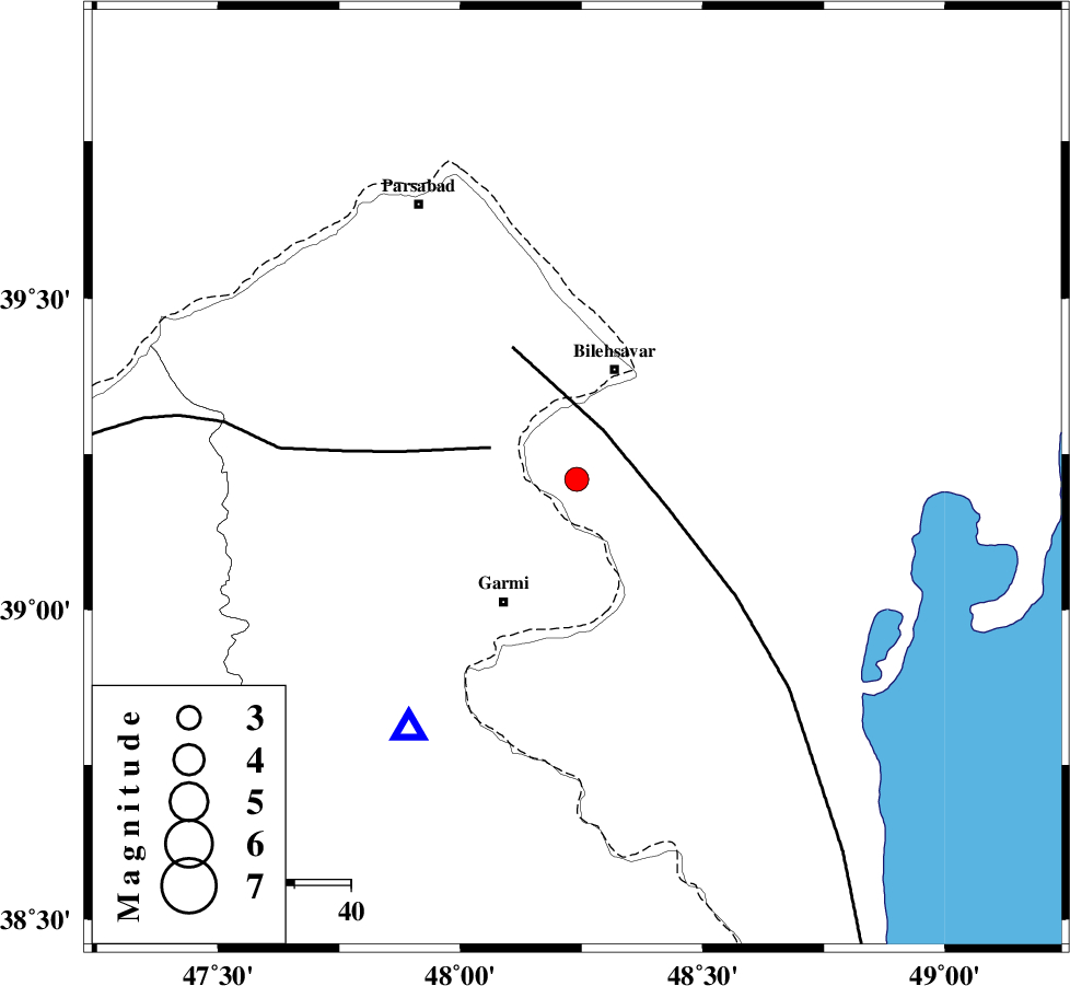
| Location | Lat:39.21 Lon: 48.24 |
| Region | 20 km South of Bileh Savar, Ardebil Province |
Nearest Cities |
|
| 11 km East of Anjirlu, Ardebil Province | |
| 13 km East of Moradlu, Ardebil Province | |
| 15 km South of Gorg tappeh, Ardebil Province | |
| 15 km North of Hasan khanlu, Ardebil Province | |
| 16 km North of Seyyedzahra, Ardebil Province | |
| Depth | 18 km |
| Agency | |
Faults within 150 km: |
|
| TALESH_F (Length: 258 km) , Distance to epicenter: 10 km | |
| DASHT_E_MOGHAN__ (Length: 104 km) , Distance to epicenter: 16 km | |
| BOZQUSH (Length: 70 km) , Distance to epicenter: 109 km | |
| Number of Phases | 8 |
| RMS | 0.1 |
| Number of Stations | 6 |
| Error in Latitude | >3.5 km |
| Error in Longitude | 4.4 km |
| Error in Depth | 8.2 km |
Download waveform in seisan format
to download seisan software Click here
to access information about IIEES stations Click here
Amplitude | ||||||||
| UID | Agency | Station | Component | Amplitude | Period | Arrival Time | Proccessing Time | Signal Clip |
| 40409 | IIEES | ZNJK | E | 64 | 0.32 | 2007-12-03 00:54:18 | 2008-04-12 10:47:00 | n |
| 40410 | IIEES | MAKU | N | 58.7 | 0.48 | 2007-12-03 00:54:28 | 2008-04-12 10:47:00 | n |
| 40411 | IIEES | THKV | E | 42.7 | 0.32 | 2007-12-03 00:54:42 | 2008-04-12 10:47:00 | n |
| 40412 | IIEES | THKV | N | 21.7 | 0.28 | 2007-12-03 00:54:43 | 2008-04-12 10:47:00 | n |
| 40413 | IIEES | DAMV | N | 16.2 | 0.52 | 2007-12-03 00:55:02 | 2008-04-12 10:47:00 | n |
| 40414 | IIEES | DAMV | E | 13 | 0.52 | 2007-12-03 00:55:05 | 2008-04-12 10:47:00 | n |
Phase | ||||||||||||
| Agency | Station | Component | Phase Type | Phase Quality | First Motion | Observed Arrival Time | Time Residual | Loc. Flag | Input Weight | Distance | Azimuth | |
| IIEES | GRMI | Z | Pg | E | 2007-12-03 00:53:03 | -0.1 | y | 53.4 | 214 | |||
| IIEES | GRMI | N | Sg | E | 2007-12-03 00:53:10 | 0.1 | y | 53.4 | 214 | |||
| IIEES | ZNJK | Z | Pn | E | 2007-12-03 00:53:36 | 0.1 | y | 284 | 172 | |||
| IIEES | MAKU | Z | Pn | E | 2007-12-03 00:53:39 | 0.2 | y | 307 | 274 | |||
| IIEES | MAKU | N | Sg | E | 2007-12-03 00:54:17 | -0.1 | y | 307 | 274 | |||
| IIEES | THKV | Z | Pn | E | 2007-12-03 00:53:54 | -0.1 | y | 433 | 147 | |||
| IIEES | DAMV | Z | Pn | E | 2007-12-03 00:54:05 | 0 | y | 516 | 139 | |||
| IIEES | ASAO | Z | Pn | E | 2007-12-03 00:54:08 | -0.1 | y | 541 | 162 | |||