
Magnitude |
3.1 |
| Date & Time (UTC) | 2008-01-21 20:17:56.9 |
| Date & Time (Local) | 1386/11/1 23:47:56.9 |
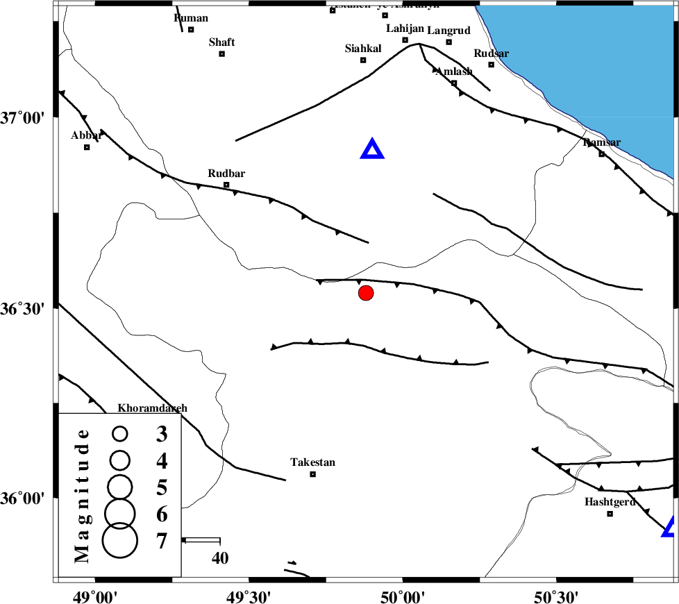
| Location | Lat:36.54 Lon: 49.88 |
| Region | 32 km North-West of Qazvin, Ghazvin Province |
Nearest Cities |
|
| 20 km South of Jirhandeh, Gilan Province | |
| 23 km South West of Kelishom, Gilan Province | |
| 25 km North East of Aqababa, Ghazvin Province | |
| 25 km North of Mahmud Abad, Ghazvin Province | |
| 28 km North East of Kuhin, Ghazvin Province | |
| Depth | 15 km |
| Agency | |
Faults within 150 km: |
|
| ALAMUTRUD_F (Length: 140 km) , Distance to epicenter: 4 km | |
| RUDBAR_F (Length: 93 km) , Distance to epicenter: 15 km | |
| N_QAZVIN_F (Length: 72 km) , Distance to epicenter: 15 km | |
| Number of Phases | 6 |
| RMS | 0.4 |
| Number of Stations | 6 |
| Error in Latitude | >9.9 km |
| Error in Longitude | 6.4 km |
| Error in Depth | 10.2 km |
Download waveform in seisan format
to download seisan software Click here
to access information about IIEES stations Click here
Amplitude | ||||||||
| UID | Agency | Station | Component | Amplitude | Period | Arrival Time | Proccessing Time | Signal Clip |
| 47957 | IIEES | ZNJK | N | 610.5 | 0.32 | 2008-01-21 20:18:28 | 2008-12-28 01:25:00 | n |
| 47958 | IIEES | THKV | E | 652 | 0.28 | 2008-01-21 20:18:34 | 2008-12-28 01:25:00 | n |
| 47959 | IIEES | GHVR | N | 101.6 | 0.48 | 2008-01-21 20:19:14 | 2008-12-28 01:25:00 | n |
| 47960 | IIEES | GHVR | E | 94.1 | 0.48 | 2008-01-21 20:19:19 | 2008-12-28 01:25:00 | n |
Phase | ||||||||||||
| Agency | Station | Component | Phase Type | Phase Quality | First Motion | Observed Arrival Time | Time Residual | Loc. Flag | Input Weight | Distance | Azimuth | |
| IIEES | ZNJK | Z | Pg | E | 2008-01-21 20:18:15 | 0 | y | 107 | 278 | |||
| IIEES | THKV | Z | Pg | E | 2008-01-21 20:18:16 | 0.3 | y | 114 | 127 | |||
| IIEES | CHTH | Z | Pg | E | 2008-01-21 20:18:18 | -0.2 | y | 133 | 122 | |||
| IIEES | DAMV | Z | Pg | E | 2008-01-21 20:18:31 | -0.4 | y | 214 | 118 | |||
| IIEES | ASAO | Z | Pg | E | 2008-01-21 20:18:32 | -0.4 | y | 222 | 176 | |||
| IIEES | GHVR | Z | Pn | E | 2008-01-21 20:18:37 | 0.7 | y | 260 | 151 | |||