
Magnitude |
3.2 |
| Date & Time (UTC) | 2008-01-30 10:57:47.3 |
| Date & Time (Local) | 1386/11/10 14:27:47.3 |
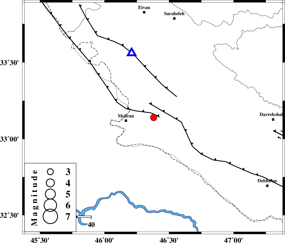
| Location | Lat:33.14 Lon: 46.38 |
| Region | 19 km East of Mehran, Ilam Province |
Nearest Cities |
|
| 20 km North East of Mehran, Ilam Province | |
| 20 km South West of Gonbad-e pirmohammad, Ilam Province | |
| 22 km South of Galeh-yedarre-hemalakshahi, Ilam Province | |
| 34 km South of Mehr, Ilam Province | |
| 41 km South East of Salehabad, Ilam Province | |
| Depth | 14 km |
| Agency | |
Faults within 150 km: |
|
| ZFF4 (Length: 128 km) , Distance to epicenter: 2 km | |
| MFF6 (Length: 144 km) , Distance to epicenter: 11 km | |
| MFF7 (Length: 99 km) , Distance to epicenter: 23 km | |
| Number of Phases | 7 |
| RMS | 0.1 |
| Number of Stations | 6 |
| Error in Latitude | >4.8 km |
| Error in Longitude | 8.6 km |
| Error in Depth | 3.5 km |
Download waveform in seisan format
to download seisan software Click here
to access information about IIEES stations Click here
Amplitude | ||||||||
| UID | Agency | Station | Component | Amplitude | Period | Arrival Time | Proccessing Time | Signal Clip |
| 48053 | IIEES | SNGE | E | 169.2 | 0.64 | 2008-01-30 10:59:24 | 2008-12-28 01:25:00 | n |
| 48054 | IIEES | SNGE | N | 118.8 | 0.68 | 2008-01-30 10:59:25 | 2008-12-28 01:25:00 | n |
| 48055 | IIEES | GHVR | E | 34.6 | 0.45 | 2008-01-30 10:59:54 | 2008-12-28 01:25:00 | n |
| 48056 | IIEES | GHVR | N | 29.8 | 0.49 | 2008-01-30 10:59:55 | 2008-12-28 01:25:00 | n |
Phase | ||||||||||||
| Agency | Station | Component | Phase Type | Phase Quality | First Motion | Observed Arrival Time | Time Residual | Loc. Flag | Input Weight | Distance | Azimuth | |
| IIEES | SNGE | Z | Pg | E | 2008-01-30 10:58:25 | -0.1 | y | 234 | 22 | |||
| IIEES | SHGR | Z | Pg | E | 2008-01-30 10:58:28 | 0 | y | 255 | 116 | |||
| IIEES | SHGR | E | Sg | E | 2008-01-30 10:58:59 | 0 | y | 255 | 116 | |||
| IIEES | ASAO | Z | Pn | E | 2008-01-30 10:58:41 | 0.2 | y | 372 | 64 | |||
| IIEES | GHVR | Z | Pn | E | 2008-01-30 10:58:54 | 0.1 | y | 475 | 70 | |||
| IIEES | CHTH | Z | Pn | E | 2008-01-30 10:59:01 | 0 | y | 533 | 54 | |||
| IIEES | DAMV | Z | PN5 | E | 2008-01-30 10:59:07 | -0.1 | y | 584 | 60 | |||