
Magnitude |
3.7 |
| Date & Time (UTC) | 2008-04-13 12:40:05.0 |
| Date & Time (Local) | 1387/1/25 17:10:05.0 |
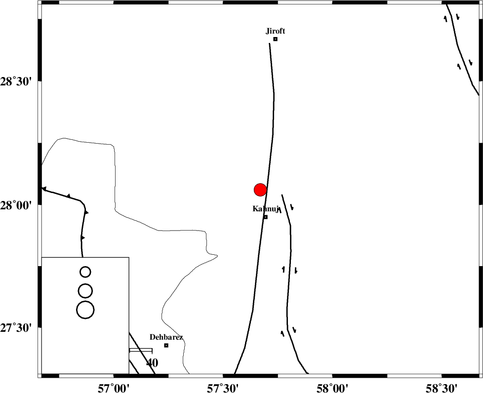
| Location | Lat:28.06 Lon: 57.67 |
| Region | 12 km North of Kahnuj, Kerman Province |
Nearest Cities |
|
| 12 km North of Kahnuj, Kerman Province | |
| 21 km South East of Bolock, Kerman Province | |
| 26 km East of Mehrueye-e paeen, Kerman Province | |
| 38 km South East of Hurpasefid, Kerman Province | |
| 39 km East of Faryab, Kerman Province | |
| Depth | 14 km |
| Agency | |
Faults within 150 km: |
|
| SABZEVARAN_F (Length: 190 km) , Distance to epicenter: 3 km | |
| JIROFT_F (Length: 144 km) , Distance to epicenter: 10 km | |
| MAIN_ZAGROS_R_F (Length: 1106 km) , Distance to epicenter: 79 km | |
| Number of Phases | 4 |
| RMS | 0.1 |
| Number of Stations | 4 |
| Error in Latitude | >3.1 km |
| Error in Longitude | 3.5 km |
| Error in Depth | 5.4 km |
Download waveform in seisan format
to download seisan software Click here
to access information about IIEES stations Click here
Amplitude | ||||||||
| UID | Agency | Station | Component | Amplitude | Period | Arrival Time | Proccessing Time | Signal Clip |
| 48857 | IIEES | BNDS | N | 675.4 | 0.52 | 2008-04-13 12:40:54 | 2009-01-18 12:56:00 | n |
| 48858 | IIEES | KRBR | N | 843.8 | 0.48 | 2008-04-13 12:41:18 | 2009-01-18 12:56:00 | n |
| 48859 | IIEES | KRBR | E | 606.7 | 0.48 | 2008-04-13 12:41:20 | 2009-01-18 12:56:00 | n |
Phase | ||||||||||||
| Agency | Station | Component | Phase Type | Phase Quality | First Motion | Observed Arrival Time | Time Residual | Loc. Flag | Input Weight | Distance | Azimuth | |
| IIEES | BNDS | Z | Pg | E | 2008-04-13 12:40:32 | -0.1 | y | 165 | 244 | |||
| IIEES | KRBR | Z | Pg | E | 2008-04-13 12:40:42 | 0 | y | 231 | 338 | |||
| IIEES | ZHSF | Z | Pn | E | 2008-04-13 12:40:56 | 0 | y | 348 | 60 | |||
| IIEES | GHIR | Z | Pn | E | 2008-04-13 12:41:10 | 0.1 | y | 461 | 274 | |||