
Magnitude |
3 |
| Date & Time (UTC) | 2008-07-12 04:27:10.8 |
| Date & Time (Local) | 1387/4/22 08:57:10.8 |
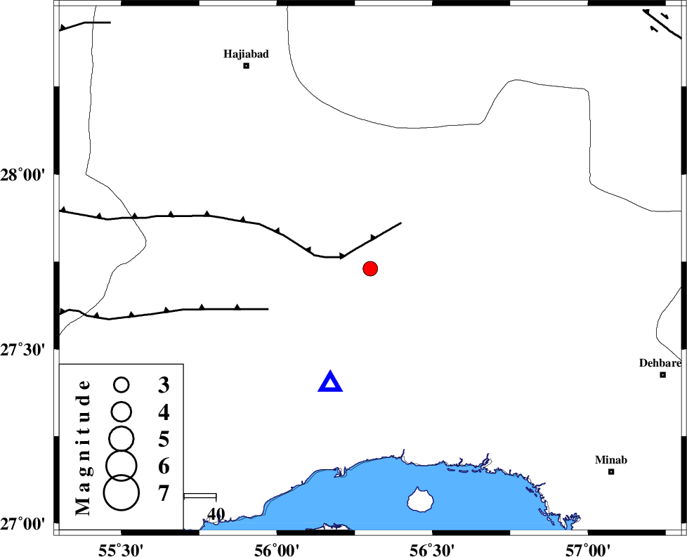
| Location | Lat:27.73 Lon: 56.3 |
| Region | 60 km North of Bandar-e abbas, Hormozgan Province |
Nearest Cities |
|
| 32 km South of Fareqan, Hormozgan Province | |
| 40 km North East of Fin, Hormozgan Province | |
| 61 km North of Bandar-e abbas, Hormozgan Province | |
| 75 km South East of Hajiabad, Hormozgan Province | |
| 79 km South of Arzuieeh, Kerman Province | |
| Depth | 14 km |
| Agency | |
Faults within 150 km: |
|
| HZF2 (Length: 437 km) , Distance to epicenter: 9 km | |
| MAIN_ZAGROS_R_F (Length: 1106 km) , Distance to epicenter: 50 km | |
| ZENDAN_MINAB_F_Z1 (Length: 183 km) , Distance to epicenter: 66 km | |
| Number of Phases | 4 |
| RMS | 0.2 |
| Number of Stations | 3 |
| Error in Latitude | >3.7 km |
| Error in Longitude | 10.4 km |
| Error in Depth | 8.7 km |
Download waveform in seisan format
to download seisan software Click here
to access information about IIEES stations Click here
Amplitude | ||||||||
| UID | Agency | Station | Component | Amplitude | Period | Arrival Time | Proccessing Time | Signal Clip |
| 49544 | IIEES | KRBR | E | 87.9 | 0.46 | 2008-07-12 04:28:40 | 2009-05-05 01:27:00 | n |
| 49545 | IIEES | KRBR | N | 93.6 | 0.41 | 2008-07-12 04:28:41 | 2009-05-05 01:27:00 | n |
| 49546 | IIEES | GHIR | E | 36.3 | 0.27 | 2008-07-12 04:28:58 | 2009-05-05 01:27:00 | n |
| 49547 | IIEES | GHIR | N | 46.1 | 0.31 | 2008-07-12 04:29:07 | 2009-05-05 01:27:00 | n |
Phase | ||||||||||||
| Agency | Station | Component | Phase Type | Phase Quality | First Motion | Observed Arrival Time | Time Residual | Loc. Flag | Input Weight | Distance | Azimuth | |
| IIEES | BNDS | Z | Pg | E | 2008-07-12 04:27:18 | -0.1 | y | 38.8 | 199 | |||
| IIEES | KRBR | Z | Pn | E | 2008-07-12 04:27:50 | 0.3 | y | 254 | 10 | |||
| IIEES | KRBR | E | Sg | E | 2008-07-12 04:28:22 | -0.2 | y | 254 | 10 | |||
| IIEES | GHIR | Z | Pn | E | 2008-07-12 04:27:59 | 0 | y | 332 | 281 | |||