
Magnitude |
3.5 |
| Date & Time (UTC) | 2008-07-21 03:20:24.9 |
| Date & Time (Local) | 1387/4/31 07:50:24.9 |
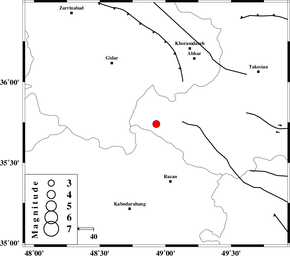
| Location | Lat:35.74 Lon: 48.93 |
| Region | 41 km North-West of Razan, Hamedan Province |
Nearest Cities |
|
| 24 km North East of Kahla, Zanjan Province | |
| 27 km North East of Khorandeh, Hamedan Province | |
| 32 km West of Ab-e garm, Ghazvin Province | |
| 33 km North West of Avaj, Ghazvin Province | |
| 35 km North East of Damag, Hamedan Province | |
| Depth | 14 km |
| Agency | |
Faults within 150 km: |
|
| KUSHK_E_NOSRAT_F (Length: 230 km) , Distance to epicenter: 18 km | |
| SOLTANIYEH_F (Length: 119 km) , Distance to epicenter: 34 km | |
| ZANJAN_F (Length: 137 km) , Distance to epicenter: 59 km | |
| Number of Phases | 7 |
| RMS | 0.2 |
| Number of Stations | 5 |
| Error in Latitude | >2 km |
| Error in Longitude | 2.2 km |
| Error in Depth | 7.4 km |
Download waveform in seisan format
to download seisan software Click here
to access information about IIEES stations Click here
Amplitude | ||||||||
| UID | Agency | Station | Component | Amplitude | Period | Arrival Time | Proccessing Time | Signal Clip |
| 49664 | IIEES | THKV | N | 440.5 | 0.5 | 2008-07-21 03:21:22 | 2009-05-05 01:27:00 | n |
| 49665 | IIEES | THKV | E | 508 | 0.47 | 2008-07-21 03:21:24 | 2009-05-05 01:27:00 | n |
| 49666 | IIEES | DAMV | N | 316.3 | 0.4 | 2008-07-21 03:21:45 | 2009-05-05 01:27:00 | n |
| 49667 | IIEES | DAMV | E | 238.8 | 0.36 | 2008-07-21 03:21:46 | 2009-05-05 01:27:00 | n |
Phase | ||||||||||||
| Agency | Station | Component | Phase Type | Phase Quality | First Motion | Observed Arrival Time | Time Residual | Loc. Flag | Input Weight | Distance | Azimuth | |
| IIEES | ZNJK | Z | Pg | E | 2008-07-21 03:20:42 | 0 | y | 105 | 348 | |||
| IIEES | ZNJK | N | Sg | E | 2008-07-21 03:20:55 | 0 | y | 105 | 348 | |||
| IIEES | SNGE | Z | Pg | E | 2008-07-21 03:20:51 | -0.1 | y | 161 | 244 | |||
| IIEES | SNGE | N | Sg | E | 2008-07-21 03:21:11 | 0.1 | y | 161 | 244 | |||
| IIEES | THKV | Z | Pg | E | 2008-07-21 03:20:54 | 0.2 | y | 177 | 83 | |||
| IIEES | CHTH | Z | Pg | E | 2008-07-21 03:20:57 | -0.3 | y | 199 | 84 | |||
| IIEES | DAMV | Z | Pn | E | 2008-07-21 03:21:07 | 0.2 | y | 275 | 92 | |||