
Magnitude |
3.4 |
| Date & Time (UTC) | 2008-10-16 13:21:08.2 |
| Date & Time (Local) | 1387/7/25 16:51:08.2 |
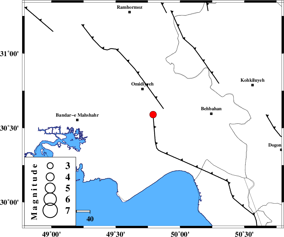
| Location | Lat:30.59 Lon: 49.79 |
| Region | 20 km South of Omidiyeh, Khoozestan Province |
Nearest Cities |
|
| 1 km North of Asiyab, Khoozestan Province | |
| 13 km South of Aghajari, Khoozestan Province | |
| 16 km South of Chah-e salem, Khoozestan Province | |
| 17 km North East of Chamkhalf-e eisa, Khoozestan Province | |
| 21 km South of Omidiyeh, Khoozestan Province | |
| Depth | 18 km |
| Agency | |
Faults within 150 km: |
|
| RAG_E_SEFID_F (Length: 84 km) , Distance to epicenter: 2 km | |
| AGHAJARI_F (Length: 88 km) , Distance to epicenter: 9 km | |
| MFF4 (Length: 62 km) , Distance to epicenter: 54 km | |
| Number of Phases | 5 |
| RMS | 0.1 |
| Number of Stations | 3 |
| Error in Latitude | >7.1 km |
| Error in Longitude | 14.8 km |
| Error in Depth | 17.5 km |
Download waveform in seisan format
to download seisan software Click here
to access information about IIEES stations Click here
Amplitude | ||||||||
| UID | Agency | Station | Component | Amplitude | Period | Arrival Time | Proccessing Time | Signal Clip |
| 50795 | IIEES | SHGR | N | 781.4 | 0.5 | 2008-10-16 13:22:07 | 2009-05-17 10:07:00 | n |
| 50796 | IIEES | GHVR | E | 38.8 | 0.68 | 2008-10-16 13:23:23 | 2009-05-17 10:07:00 | n |
| 50797 | IIEES | GHVR | N | 30.4 | 0.64 | 2008-10-16 13:23:27 | 2009-05-17 10:07:00 | n |
Phase | ||||||||||||
| Agency | Station | Component | Phase Type | Phase Quality | First Motion | Observed Arrival Time | Time Residual | Loc. Flag | Input Weight | Distance | Azimuth | |
| IIEES | SHGR | Z | Pg | E | 2008-10-16 13:21:39 | 0.1 | y | 193 | 331 | |||
| IIEES | SHGR | N | Sg | E | 2008-10-16 13:22:03 | 0 | y | 193 | 331 | |||
| IIEES | NASN | Z | Pn | E | 2008-10-16 13:22:02 | 0 | y | 376 | 49 | |||
| IIEES | NASN | N | Sn | 2008-10-16 13:22:42 | 0 | y | 376 | 49 | ||||
| IIEES | GHVR | Z | Pn | E | 2008-10-16 13:22:11 | -0.1 | y | 452 | 17 | |||