
Magnitude |
2.5 |
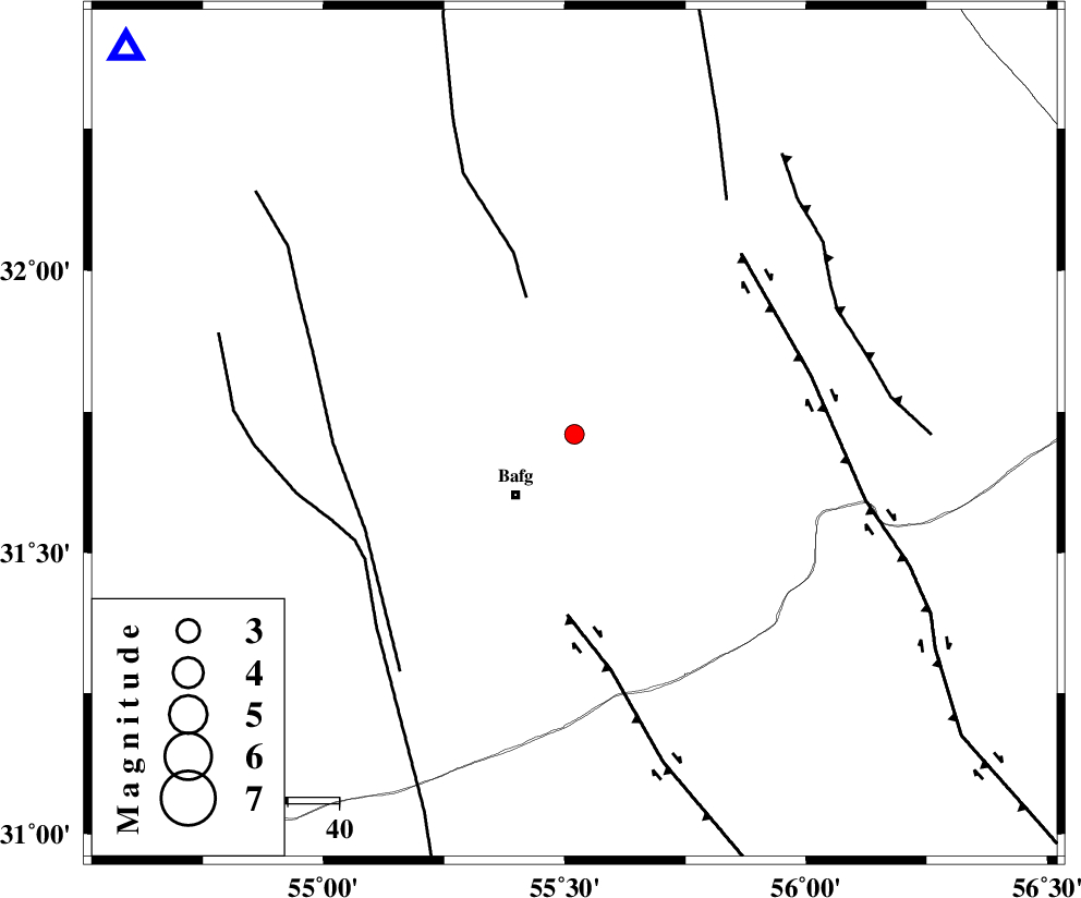
| Date & Time (UTC) | 2008-11-09 10:49:24.3 |
| Date & Time (Local) | 1387/8/19 14:19:24.3 |
| Location | Lat:31.71 Lon: 55.52 |
| Region | 16 km North-East of Bafq, Yazd Province |
Nearest Cities |
|
| 12 km North of Mobarake, Yazd Province | |
| 17 km North East of Bafq, Yazd Province | |
| 25 km West of Kushk, Yazd Province | |
| 51 km South West of Behabad, Yazd Province | |
| 51 km North West of Basab, Yazd Province | |
| Depth | 15 km |
| Agency | |
Faults within 150 km: |
|
| POSHT_E_BADAM_F (Length: 128 km) , Distance to epicenter: 28 km | |
| DARIVAN_F (Length: 131 km) , Distance to epicenter: 36 km | |
| ANAR_F (Length: 91 km) , Distance to epicenter: 45 km | |
| Number of Phases | 4 |
| RMS | 0.3 |
| Number of Stations | 4 |
| Error in Latitude | >5.4 km |
| Error in Longitude | 4 km |
| Error in Depth | 0 km |
Download waveform in seisan format
to download seisan software Click here
to access information about IIEES stations Click here
Amplitude | ||||||||
| UID | Agency | Station | Component | Amplitude | Period | Arrival Time | Proccessing Time | Signal Clip |
| 51129 | IIEES | KRBR | N | 40.3 | 0.73 | 2008-11-09 10:50:31 | 2009-05-17 10:07:00 | n |
| 51130 | IIEES | KRBR | E | 58.8 | 0.52 | 2008-11-09 10:50:35 | 2009-05-17 10:07:00 | n |
| 51131 | IIEES | NASN | E | 10.6 | 0.56 | 2008-11-09 10:50:45 | 2009-05-17 10:07:00 | n |
Phase | ||||||||||||
| Agency | Station | Component | Phase Type | Phase Quality | First Motion | Observed Arrival Time | Time Residual | Loc. Flag | Input Weight | Distance | Azimuth | |
| IIEES | KRBR | Z | PN5 | E | 2008-11-09 10:50:00 | 0.1 | y | 226 | 148 | |||
| IIEES | TABS | Z | Pn | E | 2008-11-09 10:50:04 | 0.4 | y | 262 | 35 | |||
| IIEES | NASN | Z | Pn | E | 2008-11-09 10:50:07 | -0.1 | y | 282 | 296 | |||
| IIEES | SHRT | Z | Pn | E | 2008-11-09 10:50:33 | -0.6 | y | 497 | 63 | |||