
Magnitude |
3.5 |
| Date & Time (UTC) | 2008-12-19 03:34:33.5 |
| Date & Time (Local) | 1387/9/29 07:04:33.5 |
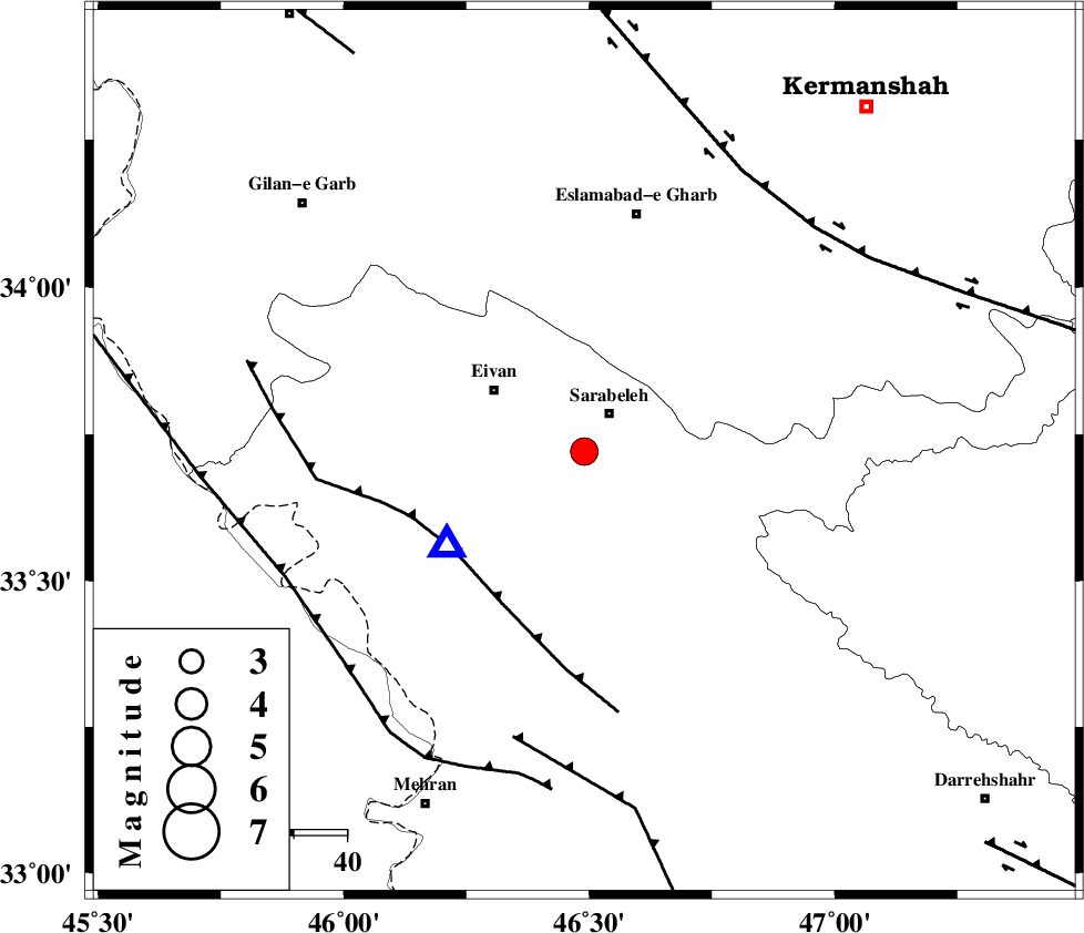
| Location | Lat:33.72 Lon: 46.49 |
| Region | 8 km Sar Ableh, Ilam Province |
Nearest Cities |
|
| 9 km of Sar Ableh, Ilam Province | |
| 11 km North of Ilam, Ilam Province | |
| 12 km South of Mohammadqoli, Ilam Province | |
| 21 km South East of Eyvan, Ilam Province | |
| 21 km North East of Chavar, Ilam Province | |
| Depth | 15 km |
| Agency | |
Faults within 150 km: |
|
| MFF7 (Length: 99 km) , Distance to epicenter: 31 km | |
| MFF6 (Length: 144 km) , Distance to epicenter: 56 km | |
| HZF4 (Length: 492 km) , Distance to epicenter: 61 km | |
| Number of Phases | 5 |
| RMS | 0.1 |
| Number of Stations | 5 |
| Error in Latitude | >3.3 km |
| Error in Longitude | 4.7 km |
| Error in Depth | 0 km |
Download waveform in seisan format
to download seisan software Click here
to access information about IIEES stations Click here
Amplitude | ||||||||
| UID | Agency | Station | Component | Amplitude | Period | Arrival Time | Proccessing Time | Signal Clip |
| 51475 | IIEES | SNGE | E | 522.7 | 0.68 | 2008-12-19 03:35:33 | 2009-05-17 10:07:00 | n |
| 51476 | IIEES | SHGR | N | 294.6 | 0.45 | 2008-12-19 03:36:02 | 2009-05-17 10:07:00 | n |
| 51477 | IIEES | SHGR | E | 247.5 | 0.48 | 2008-12-19 03:36:10 | 2009-05-17 10:07:00 | n |
| 51478 | IIEES | ASAO | N | 77.5 | 0.64 | 2008-12-19 03:36:32 | 2009-05-17 10:07:00 | n |
Phase | ||||||||||||
| Agency | Station | Component | Phase Type | Phase Quality | First Motion | Observed Arrival Time | Time Residual | Loc. Flag | Input Weight | Distance | Azimuth | |
| IIEES | SNGE | Z | Pn | E | 2008-12-19 03:35:02 | 0.1 | y | 172 | 27 | |||
| IIEES | SHGR | Z | Pn | E | 2008-12-19 03:35:15 | 0 | y | 280 | 129 | |||
| IIEES | ASAO | Z | Pn | E | 2008-12-19 03:35:23 | -0.2 | y | 339 | 73 | |||
| IIEES | ZNJK | Z | Pn | E | 2008-12-19 03:35:28 | -0.1 | y | 384 | 31 | |||
| IIEES | GHVR | Z | Pn | E | 2008-12-19 03:35:36 | 0.2 | y | 447 | 78 | |||