
Magnitude |
2.9 |
| Date & Time (UTC) | 2009-01-23 16:27:01.2 |
| Date & Time (Local) | 1387/11/4 19:57:01.2 |
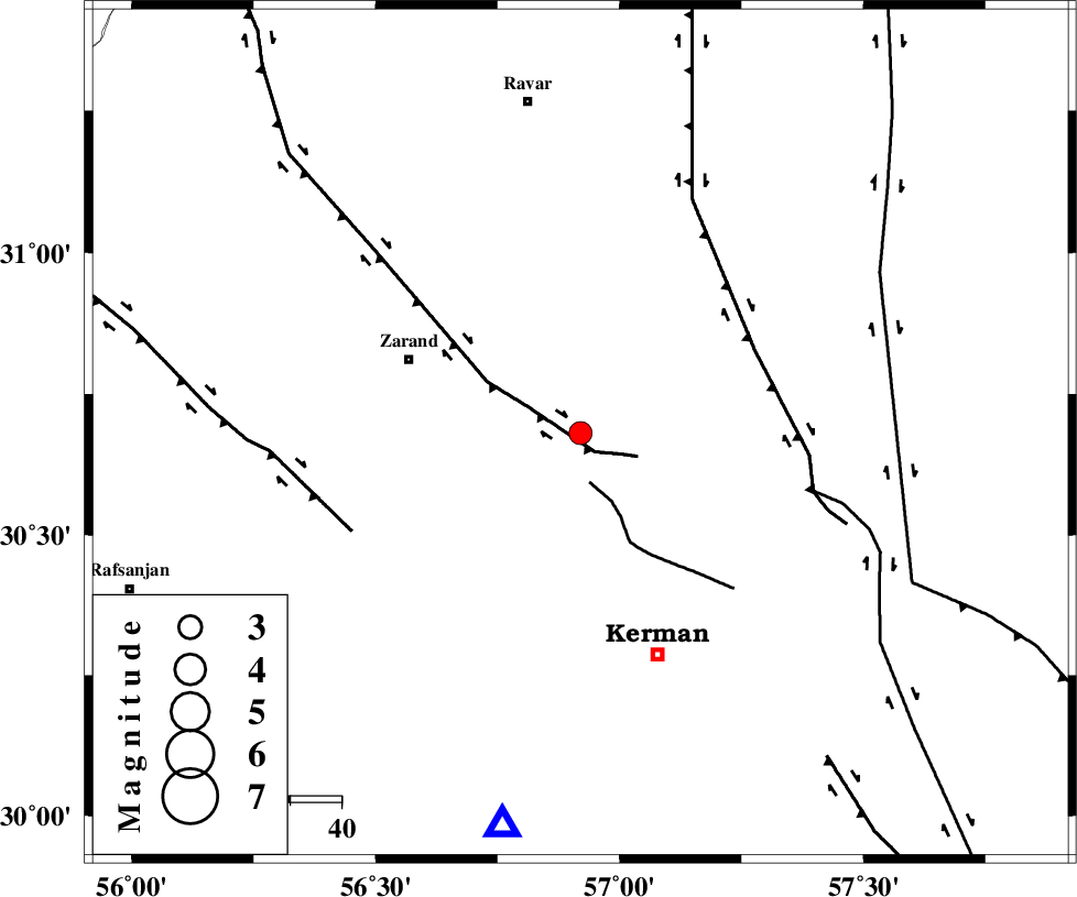
| Location | Lat:30.68 Lon: 56.92 |
| Region | 36 km South-East of Zarand, Kerman Province |
Nearest Cities |
|
| 9 km North of Chatrud, Kerman Province | |
| 10 km of Hejdak, Kerman Province | |
| 12 km North of Hutak, Kerman Province | |
| 14 km East of Khankuk, Kerman Province | |
| 14 km North of Kazemabad, Kerman Province | |
| Depth | 44 km |
| Agency | |
Faults within 150 km: |
|
| KUHBANAN_F (Length: 189 km) , Distance to epicenter: 5 km | |
| CHATRUD_F (Length: 37 km) , Distance to epicenter: 10 km | |
| LAKARKUH_F (Length: 138 km) , Distance to epicenter: 38 km | |
| Number of Phases | 6 |
| RMS | 0.1 |
| Number of Stations | 4 |
| Error in Latitude | >1.4 km |
| Error in Longitude | 3.8 km |
| Error in Depth | 2.9 km |
Download waveform in seisan format
to download seisan software Click here
to access information about IIEES stations Click here
Amplitude | ||||||||
| UID | Agency | Station | Component | Amplitude | Period | Arrival Time | Proccessing Time | Signal Clip |
| 51742 | IIEES | KRBR | N | 326 | 0.2 | 2009-01-23 16:27:31 | 2009-06-27 08:52:00 | n |
| 51743 | IIEES | TABS | N | 43.4 | 0.6 | 2009-01-23 16:28:45 | 2009-06-27 08:52:00 | n |
Phase | ||||||||||||
| Agency | Station | Component | Phase Type | Phase Quality | First Motion | Observed Arrival Time | Time Residual | Loc. Flag | Input Weight | Distance | Azimuth | |
| IIEES | KRBR | Z | Pg | E | 2009-01-23 16:27:15 | -0.2 | y | 78.6 | 191 | |||
| IIEES | KRBR | E | Sg | E | 2009-01-23 16:27:26 | 0.1 | y | 78.6 | 191 | |||
| IIEES | TABS | Z | Pn | E | 2009-01-23 16:27:46 | -0.2 | y | 330 | 3 | |||
| IIEES | TABS | N | Sg | E | 2009-01-23 16:28:31 | 0.1 | y | 330 | 3 | |||
| IIEES | ZHSF | Z | Pn | E | 2009-01-23 16:27:54 | 0.1 | y | 390 | 107 | |||
| IIEES | NASN | Z | Pn | E | 2009-01-23 16:28:03 | 0.1 | y | 455 | 302 | |||