
Magnitude |
3.3 |
| Date & Time (UTC) | 2009-01-30 23:50:39.7 |
| Date & Time (Local) | 1387/11/12 03:20:39.7 |
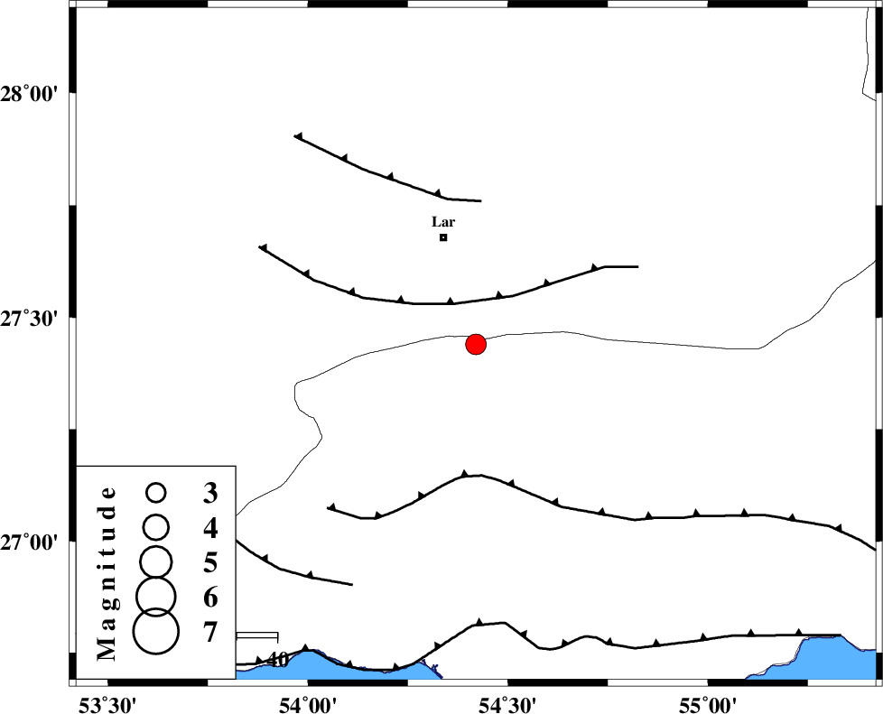
| Location | Lat:27.44 Lon: 54.42 |
| Region | 27 km South of Lar, Fars Province |
Nearest Cities |
|
| 27 km North of Bastak, Hormozgan Province | |
| 28 km South of Lar, Fars Province | |
| 29 km South of Latifi, Fars Province | |
| 34 km South East of Grash, Fars Province | |
| 39 km East of Bagh, Fars Province | |
| Depth | 15 km |
| Agency | |
Faults within 150 km: |
|
| LAR_F (Length: 99 km) , Distance to epicenter: 11 km | |
| MFF1 (Length: 180 km) , Distance to epicenter: 33 km | |
| BERIZ_F (Length: 49 km) , Distance to epicenter: 35 km | |
| Number of Phases | 3 |
| RMS | 0 |
| Number of Stations | 3 |
| Error in Latitude | >5.3 km |
| Error in Longitude | 2.2 km |
| Error in Depth | 0 km |
Download waveform in seisan format
to download seisan software Click here
to access information about IIEES stations Click here
Amplitude | ||||||||
| UID | Agency | Station | Component | Amplitude | Period | Arrival Time | Proccessing Time | Signal Clip |
| 51798 | IIEES | GHIR | E | 572.6 | 0.52 | 2009-01-30 23:51:31 | 2009-06-27 08:52:00 | n |
| 51799 | IIEES | GHIR | N | 518.7 | 0.48 | 2009-01-30 23:51:35 | 2009-06-27 08:52:00 | n |
| 51800 | IIEES | BNDS | N | 323.8 | 0.48 | 2009-01-30 23:51:41 | 2009-06-27 08:52:00 | n |
| 51801 | IIEES | KRBR | N | 66.7 | 0.6 | 2009-01-30 23:52:30 | 2009-06-27 08:52:00 | n |
| 51802 | IIEES | KRBR | E | 66.2 | 0.52 | 2009-01-30 23:52:30 | 2009-06-27 08:52:00 | n |
Phase | ||||||||||||
| Agency | Station | Component | Phase Type | Phase Quality | First Motion | Observed Arrival Time | Time Residual | Loc. Flag | Input Weight | Distance | Azimuth | |
| IIEES | GHIR | Z | Pg | E | 2009-01-30 23:51:07 | 0 | y | 169 | 304 | |||
| IIEES | BNDS | Z | Pg | E | 2009-01-30 23:51:08 | 0 | y | 174 | 91 | |||
| IIEES | KRBR | Z | Pn | E | 2009-01-30 23:51:32 | 0 | y | 363 | 39 | |||