
Magnitude |
2.7 |
| Date & Time (UTC) | 2009-02-10 06:04:31.4 |
| Date & Time (Local) | 1387/11/22 09:34:31.4 |
| Location | Lat:30.94 Lon: 56.05 |
| Region | 51 km North-West of Zarand, Kerman Province |
Nearest Cities |
|
| 10 km of Seyriz, Kerman Province | |
| 25 km North East of Ferdosiyeh, Kerman Province | |
| 32 km North East of Bahreman, Kerman Province | |
| 36 km North East of Esmaeelabad, Kerman Province | |
| 42 km South West of Toghroljerd, Kerman Province | |
| Depth | 14 km |
| Agency | |
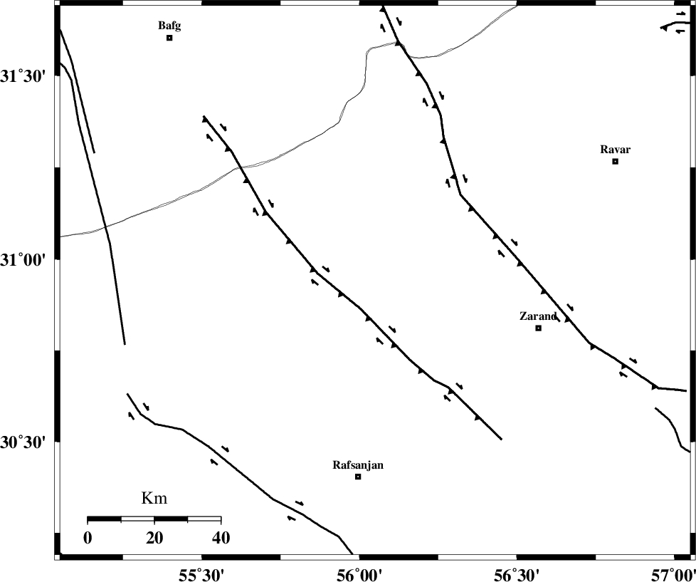
Faults within 150 km: |
|
| DARIVAN_F (Length: 131 km) , Distance to epicenter: 10 km | |
| KUHBANAN_F (Length: 189 km) , Distance to epicenter: 37 km | |
| RAFSANJAN_F (Length: 129 km) , Distance to epicenter: 71 km | |
| Number of Phases | 5 |
| RMS | 0.1 |
| Number of Stations | 4 |
| Error in Latitude | >1.4 km |
| Error in Longitude | 8.9 km |
| Error in Depth | 3.8 km |
Download waveform in seisan format
to download seisan software Click here
to access information about IIEES stations Click here
Amplitude | ||||||||
| UID | Agency | Station | Component | Amplitude | Period | Arrival Time | Proccessing Time | Signal Clip |
| 51907 | IIEES | KRBR | E | 167.7 | 0.37 | 2009-02-10 06:05:12 | 2009-06-27 08:52:00 | n |
| 51908 | IIEES | KRBR | N | 154.9 | 0.23 | 2009-02-10 06:05:12 | 2009-06-27 08:52:00 | n |
| 51909 | IIEES | TABS | N | 39.4 | 0.35 | 2009-02-10 06:06:09 | 2009-06-27 08:52:00 | n |
| 51910 | IIEES | ZHSF | N | 8.4 | 0.39 | 2009-02-10 06:06:28 | 2009-06-27 08:52:00 | n |
Phase | ||||||||||||
| Agency | Station | Component | Phase Type | Phase Quality | First Motion | Observed Arrival Time | Time Residual | Loc. Flag | Input Weight | Distance | Azimuth | |
| IIEES | KRBR | Z | Pg | E | 2009-02-10 06:04:52 | -0.1 | y | 126 | 147 | |||
| IIEES | TABS | Z | Pn | E | 2009-02-10 06:05:18 | 0.1 | y | 317 | 18 | |||
| IIEES | TABS | N | Sg | E | 2009-02-10 06:06:00 | -0.1 | y | 317 | 18 | |||
| IIEES | ZHSF | Z | Pn | E | 2009-02-10 06:05:38 | 0.1 | y | 477 | 107 | |||
| IIEES | SHRT | Z | Pn | E | 2009-02-10 06:05:41 | 0 | y | 500 | 52 | |||