
Magnitude |
4.2 |
| Date & Time (UTC) | 2009-02-22 20:54:01.3 |
| Date & Time (Local) | 1387/12/5 00:24:01.3 |
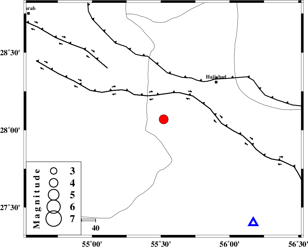
| Location | Lat:28.07 Lon: 55.52 |
| Region | 45 km South-West of Hajiabad, Hormozgan Province |
Nearest Cities |
|
| 25 km North of Darz, Fars Province | |
| 36 km South East of Fadami, Fars Province | |
| 41 km South East of Doborji, Fars Province | |
| 46 km South West of Hajiabad, Hormozgan Province | |
| 58 km South East of Tal bargah, Fars Province | |
| Depth | 14 km |
| Agency | |
Faults within 150 km: |
|
| HZF2 (Length: 437 km) , Distance to epicenter: 18 km | |
| MAIN_ZAGROS_R_F (Length: 1106 km) , Distance to epicenter: 33 km | |
| HZF1 (Length: 102 km) , Distance to epicenter: 54 km | |
| Number of Phases | 7 |
| RMS | 0.3 |
| Number of Stations | 5 |
| Error in Latitude | >6.4 km |
| Error in Longitude | 7.7 km |
| Error in Depth | 10.5 km |
Download waveform in seisan format
to download seisan software Click here
to access information about IIEES stations Click here
Amplitude | ||||||||
| UID | Agency | Station | Component | Amplitude | Period | Arrival Time | Proccessing Time | Signal Clip |
| 51992 | IIEES | KRBR | E | 986 | 0.52 | 2009-02-22 20:55:13 | 2009-06-27 08:52:00 | n |
| 51993 | IIEES | KRBR | N | 1524.6 | 0.6 | 2009-02-22 20:55:23 | 2009-06-27 08:52:00 | n |
| 51994 | IIEES | GHIR | E | 1825.3 | 0.68 | 2009-02-22 20:55:25 | 2009-06-27 08:52:00 | n |
| 51995 | IIEES | GHIR | N | 1622.4 | 0.56 | 2009-02-22 20:55:36 | 2009-06-27 08:52:00 | n |
Phase | ||||||||||||
| Agency | Station | Component | Phase Type | Phase Quality | First Motion | Observed Arrival Time | Time Residual | Loc. Flag | Input Weight | Distance | Azimuth | |
| IIEES | KRBR | Z | PN5 | E | 2009-02-22 20:54:39 | 0.4 | y | 244 | 29 | |||
| IIEES | KRBR | N | Sg | E | 2009-02-22 20:55:10 | -0.3 | y | 244 | 29 | |||
| IIEES | GHIR | Z | Pn | E | 2009-02-22 20:54:39 | -0.3 | y | 250 | 276 | |||
| IIEES | NASN | Z | Pn | E | 2009-02-22 20:55:22 | -0.1 | y | 586 | 334 | |||
| IIEES | NASN | N | Sn | 2009-02-22 20:56:21 | 0.3 | y | 586 | 334 | ||||
| IIEES | TABS | Z | Pn | E | 2009-02-22 20:55:28 | 0 | y | 638 | 13 | |||
| IIEES | DAMV | Z | Pn | E | 2009-02-22 20:56:01 | 0.1 | y | 904 | 339 | |||