
Magnitude |
3.8 |
| Date & Time (UTC) | 2009-04-14 05:10:26.6 |
| Date & Time (Local) | 1388/1/25 09:40:26.6 |
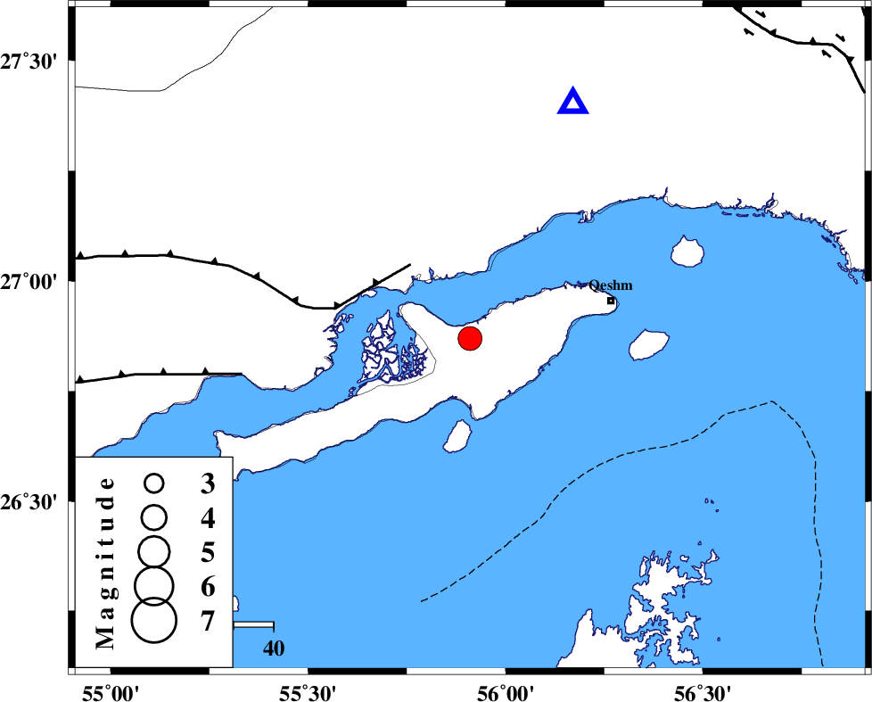
| Location | Lat:26.87 Lon: 55.91 |
| Region | Persian Gulf, 36 km West of Qeshm |
Nearest Cities |
|
| 18 km North West of Suza, Hormozgan Province | |
| 33 km East of Bandar-e khamir, Hormozgan Province | |
| 37 km West of Qeshm, Hormozgan Province | |
| 51 km South West of Bandar-e abbas, Hormozgan Province | |
| 85 km South of Fin, Hormozgan Province | |
| Depth | 8 km |
| Agency | |
Faults within 150 km: |
|
| MFF1 (Length: 180 km) , Distance to epicenter: 24 km | |
| ZFF1 (Length: 165 km) , Distance to epicenter: 58 km | |
| HZF2 (Length: 437 km) , Distance to epicenter: 106 km | |
| Number of Phases | 4 |
| RMS | 0 |
| Number of Stations | 4 |
| Error in Latitude | >8.7 km |
| Error in Longitude | 3.1 km |
| Error in Depth | 5.6 km |
Download waveform in seisan format
to download seisan software Click here
to access information about IIEES stations Click here
Amplitude | ||||||||
| UID | Agency | Station | Component | Amplitude | Period | Arrival Time | Proccessing Time | Signal Clip |
| 52428 | IIEES | BNDS | E | 7536 | 0.32 | 2009-04-14 05:10:49 | 2009-07-13 01:52:00 | n |
| 52429 | IIEES | GHIR | N | 219.7 | 0.65 | 2009-04-14 05:12:08 | 2009-07-13 01:52:00 | n |
| 52430 | IIEES | KRBR | N | 278.5 | 0.66 | 2009-04-14 05:12:06 | 2009-07-13 01:52:00 | n |
Phase | ||||||||||||
| Agency | Station | Component | Phase Type | Phase Quality | First Motion | Observed Arrival Time | Time Residual | Loc. Flag | Input Weight | Distance | Azimuth | |
| IIEES | BNDS | Z | Pg | E | 2009-04-14 05:10:37 | 0 | y | 63.8 | 24 | |||
| IIEES | GHIR | Z | Pn | E | 2009-04-14 05:11:15 | 0 | y | 328 | 299 | |||
| IIEES | KRBR | Z | Pn | E | 2009-04-14 05:11:19 | 0 | y | 354 | 13 | |||
| IIEES | ZHSF | Z | Pn | E | 2009-04-14 05:11:45 | 0 | y | 566 | 56 | |||