
Magnitude |
3 |
| Date & Time (UTC) | 2009-04-28 23:18:11.4 |
| Date & Time (Local) | 1388/2/9 03:48:11.4 |
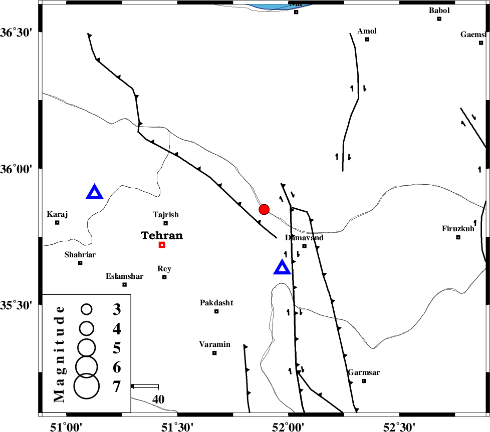
| Location | Lat:35.85 Lon: 51.89 |
| Region | 22 km North-West of Damavand, Tehran Province |
Nearest Cities |
|
| 12 km North of Bumehen, Tehran Province | |
| 13 km North of Rudehen, Tehran Province | |
| 14 km North West of Abali, Tehran Province | |
| 15 km North East of Lavasan, Tehran Province | |
| 18 km East of Afjeh, Tehran Province | |
| Depth | 15 km |
| Agency | |
Faults within 150 km: |
|
| MOSHA_F (Length: 234 km) , Distance to epicenter: 7 km | |
| N_TEHRAN_F4 (Length: 115 km) , Distance to epicenter: 10 km | |
| KANDOVAN_F (Length: 90 km) , Distance to epicenter: 33 km | |
| Number of Phases | 6 |
| RMS | 0.2 |
| Number of Stations | 5 |
| Error in Latitude | >3.6 km |
| Error in Longitude | 6.6 km |
| Error in Depth | 6.6 km |
Download waveform in seisan format
to download seisan software Click here
to access information about IIEES stations Click here
Amplitude | ||||||||
| UID | Agency | Station | Component | Amplitude | Period | Arrival Time | Proccessing Time | Signal Clip |
| 52553 | IIEES | DAMV | N | 4736.6 | 0.27 | 2009-04-28 23:18:20 | 2009-07-13 01:52:00 | n |
| 52554 | IIEES | CHTH | E | 510.1 | 0.11 | 2009-04-28 23:18:23 | 2009-07-13 01:52:00 | n |
| 52555 | IIEES | GHVR | N | 162.1 | 0.5 | 2009-04-28 23:19:03 | 2009-07-13 01:52:00 | n |
| 52556 | IIEES | GHVR | E | 260.5 | 0.42 | 2009-04-28 23:19:07 | 2009-07-13 01:52:00 | n |
Phase | ||||||||||||
| Agency | Station | Component | Phase Type | Phase Quality | First Motion | Observed Arrival Time | Time Residual | Loc. Flag | Input Weight | Distance | Azimuth | |
| IIEES | DAMV | Z | Pg | E | 2009-04-28 23:18:16 | 0 | y | 26 | 163 | |||
| IIEES | CHTH | Z | Pg | E | 2009-04-28 23:18:23 | -0.3 | y | 69 | 275 | |||
| IIEES | THKV | Z | Pg | E | 2009-04-28 23:18:27 | 0.3 | y | 91.3 | 275 | |||
| IIEES | GHVR | Z | Pg | E | 2009-04-28 23:18:38 | 0.1 | y | 163 | 201 | |||
| IIEES | GHVR | N | Sg | E | 2009-04-28 23:18:58 | 0 | y | 163 | 201 | |||
| IIEES | KHMZ | Z | Pn | E | 2009-04-28 23:18:55 | 0 | y | 293 | 217 | |||