
Magnitude |
3.3 |
| Date & Time (UTC) | 2009-06-09 19:32:29.7 |
| Date & Time (Local) | 1388/3/20 00:02:29.7 |
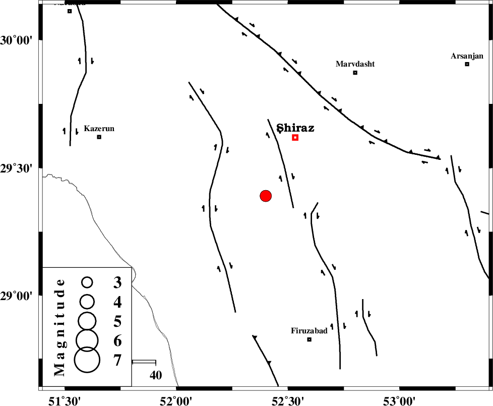
| Location | Lat:29.39 Lon: 52.4 |
| Region | 28 km South-West of Shiraz, Fars Province |
Nearest Cities |
|
| 23 km South West of Soltanabad, Fars Province | |
| 26 km South East of Richi, Fars Province | |
| 28 km South West of Shiraz, Fars Province | |
| 32 km North West of Tasuj, Fars Province | |
| 35 km North East of Dadanjan, Fars Province | |
| Depth | 15 km |
| Agency | |
Faults within 150 km: |
|
| SABZ_PUSHAN_F_Z3 (Length: 37 km) , Distance to epicenter: 13 km | |
| SABZ_PUSHAN_F_Z1 (Length: 69 km) , Distance to epicenter: 21 km | |
| KAREBASS_F (Length: 98 km) , Distance to epicenter: 24 km | |
| Number of Phases | 6 |
| RMS | 0.1 |
| Number of Stations | 6 |
| Error in Latitude | >1.5 km |
| Error in Longitude | 2.6 km |
| Error in Depth | 0 km |
Download waveform in seisan format
to download seisan software Click here
to access information about IIEES stations Click here
Amplitude | ||||||||
| UID | Agency | Station | Component | Amplitude | Period | Arrival Time | Proccessing Time | Signal Clip |
| 52915 | IIEES | GHIR | N | 1034.3 | 0.58 | 2009-06-09 19:33:16 | 2009-07-13 01:52:00 | n |
| 52916 | IIEES | KRBR | E | 33.2 | 0.62 | 2009-06-09 19:34:40 | 2009-07-13 01:52:00 | n |
| 52917 | IIEES | KRBR | N | 34.2 | 0.49 | 2009-06-09 19:34:50 | 2009-07-13 01:52:00 | n |
Phase | ||||||||||||
| Agency | Station | Component | Phase Type | Phase Quality | First Motion | Observed Arrival Time | Time Residual | Loc. Flag | Input Weight | Distance | Azimuth | |
| IIEES | GHIR | Z | Pg | E | 2009-06-09 19:32:52 | 0 | y | 135 | 155 | |||
| IIEES | KRBR | Z | Pn | E | 2009-06-09 19:33:30 | 0.1 | y | 427 | 80 | |||
| IIEES | ASAO | Z | Pn | E | 2009-06-09 19:33:53 | 0 | y | 615 | 339 | |||
| IIEES | TABS | Z | Pn | E | 2009-06-09 19:33:57 | -0.1 | y | 651 | 42 | |||
| IIEES | SNGE | Z | Pn | E | 2009-06-09 19:34:15 | 0 | y | 792 | 324 | |||
| IIEES | ZHSF | Z | Pn | E | 2009-06-09 19:34:18 | 0 | y | 812 | 86 | |||