
Magnitude |
2.5 |
| Date & Time (UTC) | 2009-06-13 17:12:31.3 |
| Date & Time (Local) | 1388/3/23 21:42:31.3 |
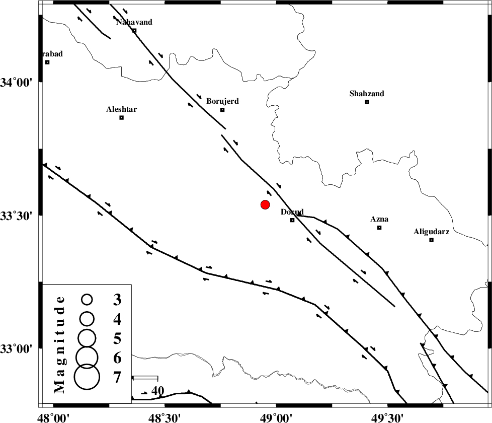
| Location | Lat:33.54 Lon: 48.95 |
| Region | 12 km West of Dorud, Lorestan Province |
Nearest Cities |
|
| 3 km North of Void, Lorestan Province | |
| 8 km of Razan, Lorestan Province | |
| 8 km of Kagheh, Lorestan Province | |
| 13 km North West of Dorud, Lorestan Province | |
| 15 km South of Chalanchulan, Lorestan Province | |
| Depth | 15 km |
| Agency | |
Faults within 150 km: |
|
| DORUD (Length: 100 km) , Distance to epicenter: 7 km | |
| MAIN_ZAGROS_R_F (Length: 1106 km) , Distance to epicenter: 14 km | |
| NAHAVAND_F (Length: 102 km) , Distance to epicenter: 36 km | |
| Number of Phases | 6 |
| RMS | 0.2 |
| Number of Stations | 4 |
| Error in Latitude | >3.7 km |
| Error in Longitude | 2.2 km |
| Error in Depth | 0 km |
Download waveform in seisan format
to download seisan software Click here
to access information about IIEES stations Click here
Amplitude | ||||||||
| UID | Agency | Station | Component | Amplitude | Period | Arrival Time | Proccessing Time | Signal Clip |
| 52969 | IIEES | ASAO | N | 88.1 | 0.98 | 2009-06-13 17:13:19 | 2009-07-13 01:52:00 | n |
| 52970 | IIEES | GHVR | E | 34.3 | 0.07 | 2009-06-13 17:13:47 | 2009-07-13 01:52:00 | n |
Phase | ||||||||||||
| Agency | Station | Component | Phase Type | Phase Quality | First Motion | Observed Arrival Time | Time Residual | Loc. Flag | Input Weight | Distance | Azimuth | |
| IIEES | KHMZ | Z | Pg | E | 2009-06-13 17:12:47 | -0.2 | y | 96.4 | 77 | |||
| IIEES | KHMZ | E | Sg | E | 2009-06-13 17:12:59 | -0.1 | y | 96.4 | 77 | |||
| IIEES | ASAO | Z | Pg | E | 2009-06-13 17:12:56 | 0.1 | y | 149 | 41 | |||
| IIEES | ASAO | N | Sg | E | 2009-06-13 17:13:14 | 0 | y | 149 | 41 | |||
| IIEES | SNGE | Z | Pg | E | 2009-06-13 17:13:08 | -0.1 | y | 227 | 320 | |||
| IIEES | GHVR | Z | Pg | E | 2009-06-13 17:13:10 | 0.4 | y | 236 | 63 | |||