
Magnitude |
2.6 |
| Date & Time (UTC) | 2010-01-16 05:48:06.5 |
| Date & Time (Local) | 1388/10/26 09:18:06.5 |
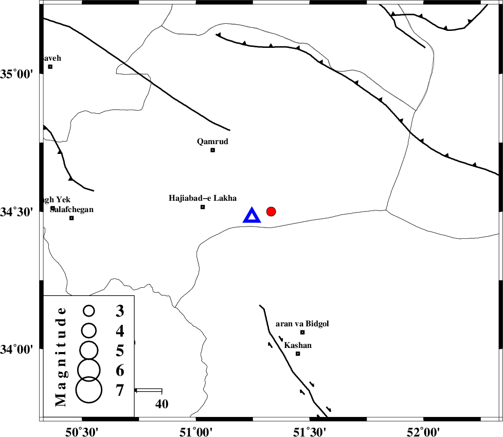
| Location | Lat:34.5 Lon: 51.33 |
| Region | 45 km South-East of Qom, Qom Province |
Nearest Cities |
|
| 28 km East of Hajiabad-e lakha, Qom Province | |
| 34 km South East of Qamrud, Qom Province | |
| 37 km North of Mashgan, Esfahan Province | |
| 41 km North of Nasrabad, Esfahan Province | |
| 41 km North East of Yahyaabad, Esfahan Province | |
| Depth | 6 km |
| Agency | |
Faults within 150 km: |
|
| KUSHK_E_NOSRAT_F (Length: 230 km) , Distance to epicenter: 37 km | |
| KASHAN_F (Length: 44 km) , Distance to epicenter: 38 km | |
| SIAHKUH_F (Length: 154 km) , Distance to epicenter: 62 km | |
| Number of Phases | 6 |
| RMS | 0.1 |
| Number of Stations | 4 |
| Error in Latitude | >3 km |
| Error in Longitude | 3 km |
| Error in Depth | 9.9 km |
Download waveform in seisan format
to download seisan software Click here
to access information about IIEES stations Click here
Amplitude | ||||||||
| UID | Agency | Station | Component | Amplitude | Period | Arrival Time | Proccessing Time | Signal Clip |
| 54090 | IIEES | DAMV | E | 128.1 | 0.31 | 2010-01-16 05:48:53 | 2010-01-16 06:02:00 | n |
| 54091 | IIEES | DAMV | N | 87.7 | 0.14 | 2010-01-16 05:48:54 | 2010-01-16 06:02:00 | n |
Phase | ||||||||||||
| Agency | Station | Component | Phase Type | Phase Quality | First Motion | Observed Arrival Time | Time Residual | Loc. Flag | Input Weight | Distance | Azimuth | |
| IIEES | ASAO | Z | Pg | E | 2010-01-16 05:48:27 | -0.2 | y | 120 | 273 | |||
| IIEES | ASAO | N | Sg | E | 2010-01-16 05:48:42 | 0.1 | y | 120 | 273 | |||
| IIEES | DAMV | Z | Pg | E | 2010-01-16 05:48:30 | -0.1 | y | 139 | 25 | |||
| IIEES | CHTH | Z | Pg | E | 2010-01-16 05:48:33 | -0.1 | y | 158 | 353 | |||
| IIEES | CHTH | N | Sg | E | 2010-01-16 05:48:53 | 0.1 | y | 158 | 353 | |||
| IIEES | NASN | Z | Pn | E | 2010-01-16 05:48:44 | 0.1 | y | 233 | 143 | |||