
Magnitude |
3.4 |
| Date & Time (UTC) | 2009-07-06 12:01:27.0 |
| Date & Time (Local) | 1388/4/15 16:31:27.0 |
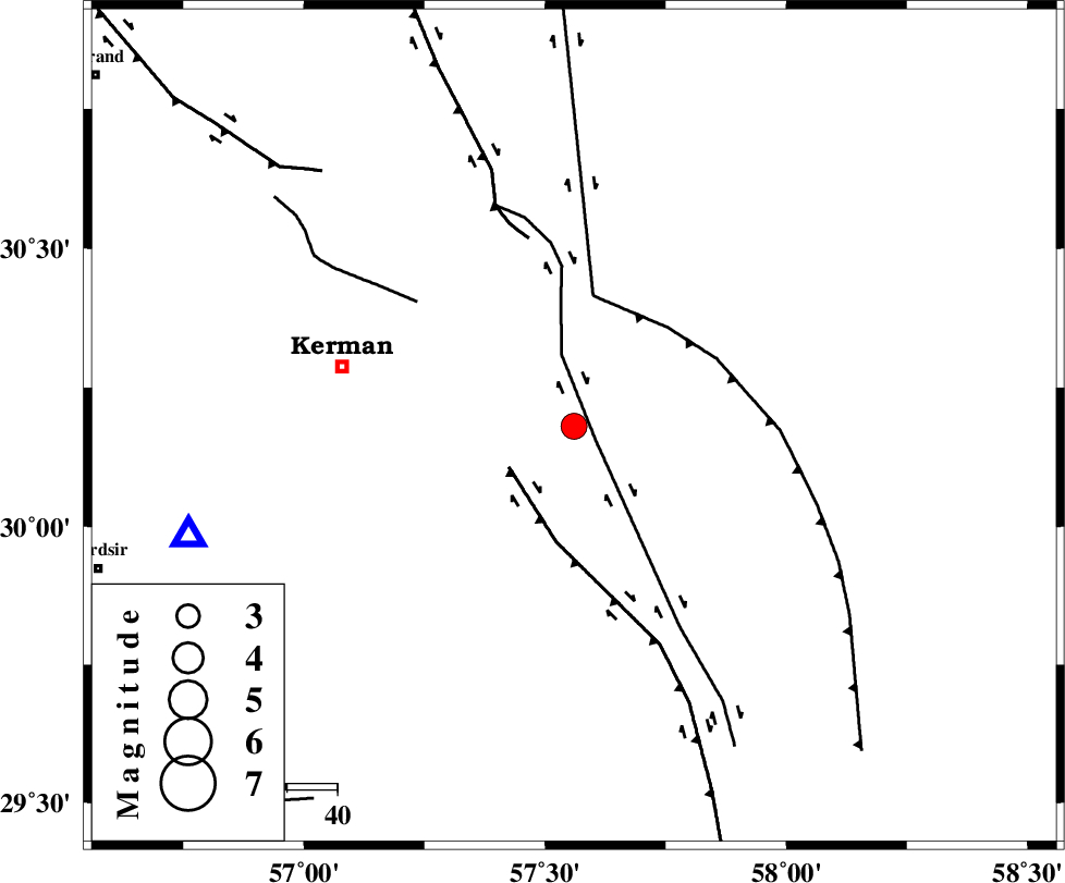
| Location | Lat:30.18 Lon: 57.56 |
| Region | Kerman Province, 48 km South-East of Kerman |
Nearest Cities |
|
| 2 km of Sirch, Kerman Province | |
| 10 km North of Jushan, Kerman Province | |
| 29 km South West of Shahdad, Kerman Province | |
| 30 km North East of Mahan, Kerman Province | |
| 30 km North East of Langar, Kerman Province | |
| Depth | 15 km |
| Agency | |
Faults within 150 km: |
|
| GOLBAF_SIRCH_F (Length: 114 km) , Distance to epicenter: 5 km | |
| GOWK_F (Length: 152 km) , Distance to epicenter: 15 km | |
| NAYBAND_F (Length: 258 km) , Distance to epicenter: 26 km | |
| Number of Phases | 5 |
| RMS | 0.2 |
| Number of Stations | 5 |
| Error in Latitude | >3.4 km |
| Error in Longitude | 2.7 km |
| Error in Depth | 0 km |
Download waveform in seisan format
to download seisan software Click here
to access information about IIEES stations Click here
Amplitude | ||||||||
| UID | Agency | Station | Component | Amplitude | Period | Arrival Time | Proccessing Time | Signal Clip |
| 57838 | IIEES | BNDS | N | 151.1 | 0.49 | 2009-07-06 12:03:07 | 2009-10-25 09:10:00 | n |
| 57839 | IIEES | SHRT | E | 41.6 | 0.4 | 2009-07-06 12:03:53 | 2009-10-25 09:10:00 | n |
Phase | ||||||||||||
| Agency | Station | Component | Phase Type | Phase Quality | First Motion | Observed Arrival Time | Time Residual | Loc. Flag | Input Weight | Distance | Azimuth | |
| IIEES | BNDS | Z | Pn | E | 2009-07-06 12:02:16 | -0.1 | y | 337 | 204 | |||
| IIEES | TABS | Z | Pn | E | 2009-07-06 12:02:22 | -0.3 | y | 387 | 354 | |||
| IIEES | SHRT | Z | Pn | E | 2009-07-06 12:02:32 | 0.1 | y | 463 | 33 | |||
| IIEES | GHIR | Z | PN5 | E | 2009-07-06 12:02:35 | 0.1 | y | 492 | 246 | |||
| IIEES | MRVT | Z | Pn | E | 2009-07-06 12:03:19 | 0.5 | y | 841 | 351 | |||