
Magnitude |
2.9 |
| Date & Time (UTC) | 2009-08-13 14:25:36.0 |
| Date & Time (Local) | 1388/5/22 18:55:36.0 |
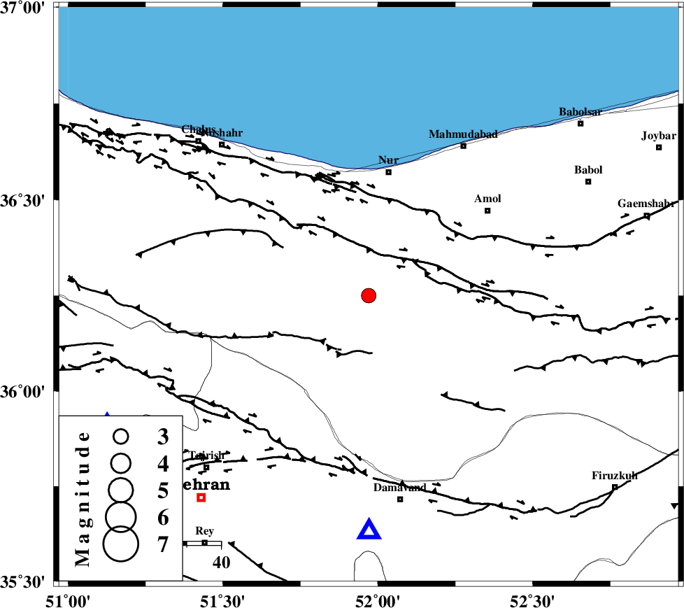
| Location | Lat:36.25 Lon: 51.97 |
| Region | Mazandaran Province, 37 km South of Nur |
Nearest Cities |
|
| 9 km North of Pil, Mazandaran Province | |
| 16 km North East of Baladeh, Mazandaran Province | |
| 27 km South East of Kujur, Mazandaran Province | |
| 28 km South West of Chamestan, Mazandaran Province | |
| 33 km South East of Narenj bon, Mazandaran Province | |
| Depth | 14 km |
| Agency | |
Faults within 150 km: |
|
| N_ALBORZ_F (Length: 360 km) , Distance to epicenter: 15 km | |
| KANDOVAN_F (Length: 90 km) , Distance to epicenter: 16 km | |
| KHAZAR_F (Length: 523 km) , Distance to epicenter: 28 km | |
| Number of Phases | 8 |
| RMS | 0.3 |
| Number of Stations | 6 |
| Error in Latitude | >7.6 km |
| Error in Longitude | 5.5 km |
| Error in Depth | 9.3 km |
Download waveform in seisan format
to download seisan software Click here
to access information about IIEES stations Click here
Amplitude | ||||||||
| UID | Agency | Station | Component | Amplitude | Period | Arrival Time | Proccessing Time | Signal Clip |
| 58231 | IIEES | GHVR | N | 100.8 | 0.48 | 2009-08-13 14:26:42 | 2009-10-27 01:20:00 | n |
| 58232 | IIEES | GHVR | E | 134 | 0.56 | 2009-08-13 14:26:45 | 2009-10-27 01:20:00 | n |
| 58233 | IIEES | ASAO | E | 67.2 | 0.64 | 2009-08-13 14:26:53 | 2009-10-27 01:20:00 | n |
Phase | ||||||||||||
| Agency | Station | Component | Phase Type | Phase Quality | First Motion | Observed Arrival Time | Time Residual | Loc. Flag | Input Weight | Distance | Azimuth | |
| IIEES | DAMV | Z | Pg | E | 2009-08-13 14:25:47 | -0.4 | y | 68.4 | 180 | |||
| IIEES | CHTH | Z | Pg | E | 2009-08-13 14:25:50 | -0.4 | y | 84.9 | 244 | |||
| IIEES | CHTH | E | Sg | E | 2009-08-13 14:26:01 | 0.1 | y | 84.9 | 244 | |||
| IIEES | THKV | Z | Pg | E | 2009-08-13 14:25:53 | 0 | y | 105 | 250 | |||
| IIEES | GHVR | Z | Pg | E | 2009-08-13 14:26:10 | 0.5 | y | 207 | 199 | |||
| IIEES | ASAO | Z | Pn | E | 2009-08-13 14:26:16 | 0.4 | y | 258 | 224 | |||
| IIEES | ASAO | E | Sg | E | 2009-08-13 14:26:49 | -0.1 | y | 258 | 224 | |||
| IIEES | NASN | Z | Pn | E | 2009-08-13 14:26:32 | -0.1 | y | 390 | 168 | |||