
Magnitude |
2.9 |
| Date & Time (UTC) | 2009-08-20 23:19:20.9 |
| Date & Time (Local) | 1388/5/30 03:49:20.9 |
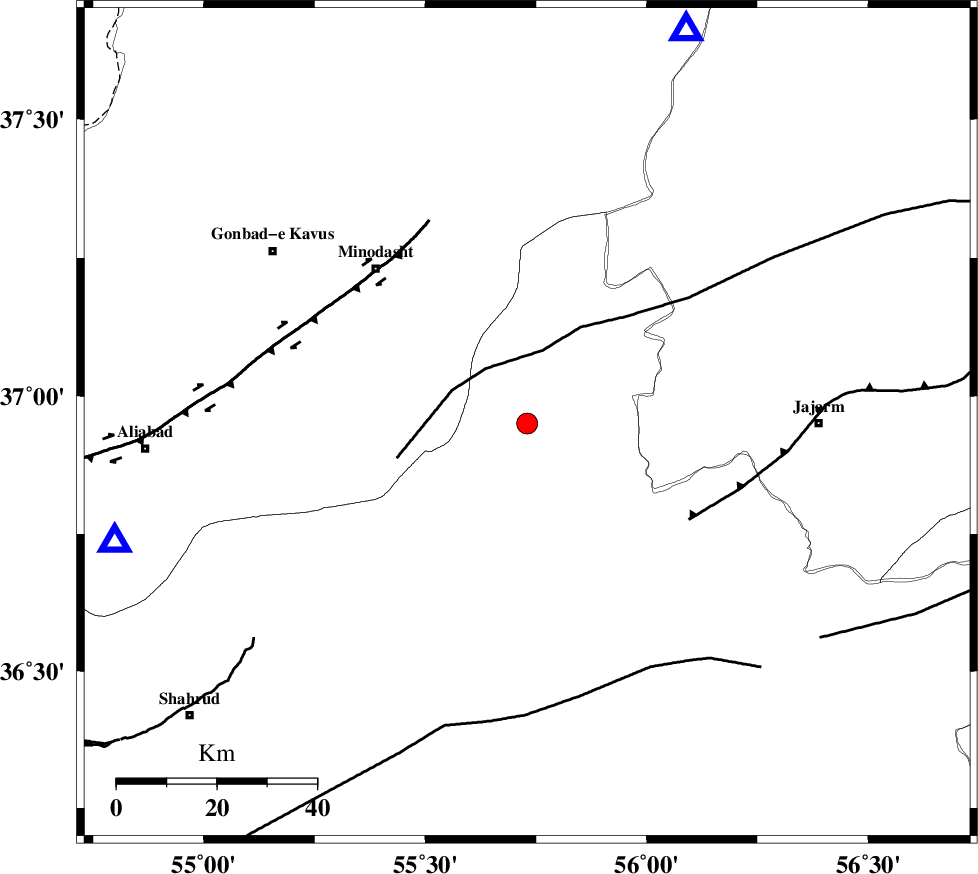
| Location | Lat:36.95 Lon: 55.73 |
| Region | Semnan Province, 44 km South-East of Minodasht |
Nearest Cities |
|
| 10 km of Qaleh qafeh, Semnan Province | |
| 10 km of Nardin, Semnan Province | |
| 18 km South of Rezvan, Semnan Province | |
| 23 km East of Qale-ye qafeh, Golestan Province | |
| 23 km South East of Duzin, Golestan Province | |
| Depth | 6 km |
| Agency | |
Faults within 150 km: |
|
| ROBATE_QARABIL_F (Length: 168 km) , Distance to epicenter: 14 km | |
| JAJARAM_F (Length: 77 km) , Distance to epicenter: 38 km | |
| SHAVAR_F (Length: 87 km) , Distance to epicenter: 50 km | |
| Number of Phases | 4 |
| RMS | 0 |
| Number of Stations | 4 |
| Error in Latitude | >1.5 km |
| Error in Longitude | 4.2 km |
| Error in Depth | 4.2 km |
Download waveform in seisan format
to download seisan software Click here
to access information about IIEES stations Click here
Amplitude | ||||||||
| UID | Agency | Station | Component | Amplitude | Period | Arrival Time | Proccessing Time | Signal Clip |
| 58441 | IIEES | MRVT | N | 207.2 | 0.34 | 2009-08-20 23:19:51 | 2009-10-27 01:20:00 | n |
| 58442 | IIEES | DAMV | N | 35.6 | 0.6 | 2009-08-20 23:21:08 | 2009-10-27 01:20:00 | n |
| 58443 | IIEES | DAMV | E | 38.5 | 0.52 | 2009-08-20 23:21:16 | 2009-10-27 01:20:00 | n |
Phase | ||||||||||||
| Agency | Station | Component | Phase Type | Phase Quality | First Motion | Observed Arrival Time | Time Residual | Loc. Flag | Input Weight | Distance | Azimuth | |
| IIEES | MRVT | Z | Pg | E | 2009-08-20 23:19:35 | 0 | y | 85.3 | 22 | |||
| IIEES | SHRO | Z | Pg | E | 2009-08-20 23:19:39 | 0 | y | 107 | 166 | |||
| IIEES | DAMV | Z | Pn | E | 2009-08-20 23:20:15 | 0 | y | 368 | 248 | |||
| IIEES | TABS | Z | Pn | E | 2009-08-20 23:20:17 | 0 | y | 387 | 161 | |||