
Magnitude |
3.2 |
| Date & Time (UTC) | 2009-11-16 03:00:09.4 |
| Date & Time (Local) | 1388/8/25 06:30:09.4 |
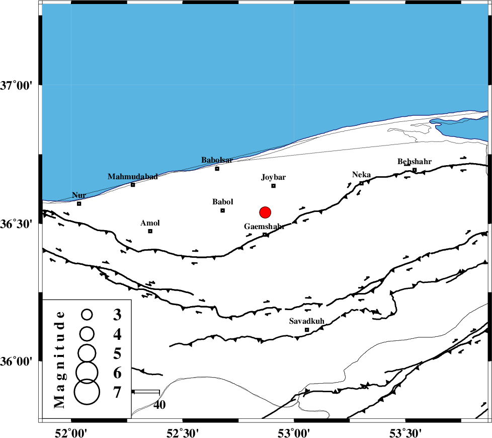
| Location | Lat:36.54 Lon: 52.87 |
| Region | Mazandaran Province, 9 km Qaemshahr |
Nearest Cities |
|
| 5 km North of Rekabdar kola, Mazandaran Province | |
| 6 km North of Sangtab, Mazandaran Province | |
| 9 km North of Qaemshahr, Mazandaran Province | |
| 11 km of Gelird, Mazandaran Province | |
| 11 km of Joybar, Mazandaran Province | |
| Depth | 25 km |
| Agency | |
Faults within 150 km: |
|
| KHAZAR_F (Length: 523 km) , Distance to epicenter: 11 km | |
| N_ALBORZ_F (Length: 360 km) , Distance to epicenter: 39 km | |
| ATARI_F (Length: 185 km) , Distance to epicenter: 94 km | |
| Number of Phases | 6 |
| RMS | 0 |
| Number of Stations | 5 |
| Error in Latitude | >3.2 km |
| Error in Longitude | 2.7 km |
| Error in Depth | 3.4 km |
Download waveform in seisan format
to download seisan software Click here
to access information about IIEES stations Click here
Amplitude | ||||||||
| UID | Agency | Station | Component | Amplitude | Period | Arrival Time | Proccessing Time | Signal Clip |
| 59335 | IIEES | DAMV | E | 474.4 | 0.56 | 2009-11-16 03:00:51 | 2010-02-08 11:55:00 | n |
| 59336 | IIEES | GHVR | E | 96.3 | 0.36 | 2009-11-16 03:01:29 | 2010-02-08 11:55:00 | n |
| 59337 | IIEES | GHVR | N | 109.9 | 0.44 | 2009-11-16 03:01:30 | 2010-02-08 11:55:00 | n |
Phase | ||||||||||||
| Agency | Station | Component | Phase Type | Phase Quality | First Motion | Observed Arrival Time | Time Residual | Loc. Flag | Input Weight | Distance | Azimuth | |
| IIEES | DAMV | Z | Pg | E | 2009-11-16 03:00:30 | 0 | y | 129 | 219 | |||
| IIEES | DAMV | E | Sg | E | 2009-11-16 03:00:46 | 0 | y | 129 | 219 | |||
| IIEES | CHTH | Z | Pg | E | 2009-11-16 03:00:37 | 0 | y | 172 | 246 | |||
| IIEES | GHVR | Z | Pn | E | 2009-11-16 03:00:50 | 0.1 | y | 272 | 213 | |||
| IIEES | SHRO | Z | Pn | E | 2009-11-16 03:00:52 | 0 | y | 289 | 101 | |||
| IIEES | ASAO | Z | Pn | E | 2009-11-16 03:00:58 | -0.1 | y | 340 | 230 | |||