
Magnitude |
2.5 |
| Date & Time (UTC) | 2009-12-25 22:15:43.8 |
| Date & Time (Local) | 1388/10/5 01:45:43.8 |
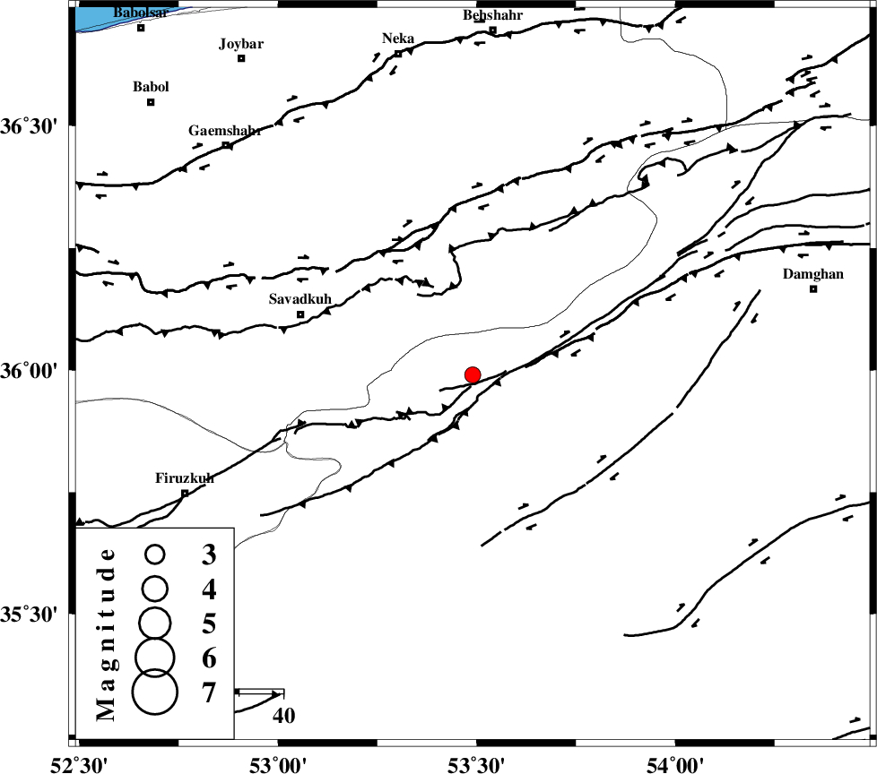
| Location | Lat:35.99 Lon: 53.49 |
| Region | Semnan Province, 48 km North of Semnan |
Nearest Cities |
|
| 23 km North East of Chashem, Semnan Province | |
| 25 km East of Sangdeh, Mazandaran Province | |
| 27 km South of Kiasar, Mazandaran Province | |
| 29 km North East of Shahmirzad, Semnan Province | |
| 31 km South West of Talma darreh, Mazandaran Province | |
| Depth | 16 km |
| Agency | |
Faults within 150 km: |
|
| ATARI_F (Length: 185 km) , Distance to epicenter: 27 km | |
| N_ALBORZ_F (Length: 360 km) , Distance to epicenter: 35 km | |
| DAMGHAN_F (Length: 95 km) , Distance to epicenter: 36 km | |
| Number of Phases | 5 |
| RMS | 0 |
| Number of Stations | 5 |
| Error in Latitude | >8.9 km |
| Error in Longitude | 1.4 km |
| Error in Depth | 5.4 km |
Download waveform in seisan format
to download seisan software Click here
to access information about IIEES stations Click here
Amplitude | ||||||||
| UID | Agency | Station | Component | Amplitude | Period | Arrival Time | Proccessing Time | Signal Clip |
| 59698 | IIEES | DAMV | N | 82.1 | 0.36 | 2009-12-25 22:16:32 | 2010-02-08 11:55:00 | n |
| 59699 | IIEES | DAMV | E | 80.4 | 0.36 | 2009-12-25 22:16:32 | 2010-02-08 11:55:00 | n |
| 59700 | IIEES | ASAO | E | 12.6 | 0.83 | 2009-12-25 22:17:24 | 2010-02-08 11:55:00 | n |
Phase | ||||||||||||
| Agency | Station | Component | Phase Type | Phase Quality | First Motion | Observed Arrival Time | Time Residual | Loc. Flag | Input Weight | Distance | Azimuth | |
| IIEES | DAMV | Z | Pg | E | 2009-12-25 22:16:07 | 0 | y | 143 | 254 | |||
| IIEES | CHTH | Z | Pg | E | 2009-12-25 22:16:18 | 0 | y | 214 | 268 | |||
| IIEES | SHRO | Z | Pg | E | 2009-12-25 22:16:21 | 0 | y | 227 | 89 | |||
| IIEES | ASAO | Z | Pn | E | 2009-12-25 22:16:35 | 0 | y | 354 | 244 | |||
| IIEES | TABS | Z | Pn | E | 2009-12-25 22:16:43 | 0 | y | 421 | 127 | |||