
Magnitude |
2.9 |
| Date & Time (UTC) | 2010-05-07 17:28:23.6 |
| Date & Time (Local) | 1389/2/17 21:58:23.6 |
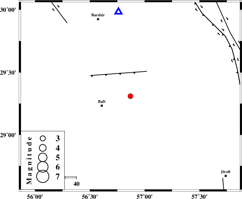
| Location | Lat:29.31 Lon: 56.87 |
| Region | Kerman Province, 26 km East of Baft |
Nearest Cities |
|
| 4 km of Askar, Kerman Province | |
| 5 km North of Rabar, Kerman Province | |
| 6 km of Siyah bonueyeh, Kerman Province | |
| 12 km North West of Kahnuj, Kerman Province | |
| 18 km North East of Bezanjan, Kerman Province | |
| Depth | 14 km |
| Agency | |
Faults within 150 km: |
|
| LALEHZAR_F (Length: 52 km) , Distance to epicenter: 26 km | |
| RAFSANJAN_F (Length: 129 km) , Distance to epicenter: 86 km | |
| GOWK_F (Length: 152 km) , Distance to epicenter: 97 km | |
| Number of Phases | 4 |
| RMS | 0.1 |
| Number of Stations | 4 |
| Error in Latitude | >2.5 km |
| Error in Longitude | 8.7 km |
| Error in Depth | 5.8 km |
Download waveform in seisan format
to download seisan software Click here
to access information about IIEES stations Click here
Amplitude | ||||||||
| UID | Agency | Station | Component | Amplitude | Period | Arrival Time | Proccessing Time | Signal Clip |
| 61870 | IIEES | KRBR | N | 434.4 | 0.31 | 2010-05-07 17:28:50 | 2010-05-07 05:50:00 | n |
| 61871 | IIEES | KRBR | E | 557.8 | 0.12 | 2010-05-07 17:28:52 | 2010-05-07 05:50:00 | n |
| 61872 | IIEES | BNDS | N | 79.3 | 0.71 | 2010-05-07 17:29:40 | 2010-05-07 05:50:00 | n |
| 61873 | IIEES | GHIR | E | 24.6 | 0.31 | 2010-05-07 17:30:14 | 2010-05-07 05:50:00 | n |
| 61874 | IIEES | GHIR | N | 22.2 | 0.1 | 2010-05-07 17:30:22 | 2010-05-07 05:50:00 | n |
Phase | ||||||||||||
| Agency | Station | Component | Phase Type | Phase Quality | First Motion | Observed Arrival Time | Time Residual | Loc. Flag | Input Weight | Distance | Azimuth | |
| IIEES | KRBR | Z | Pg | E | 2010-05-07 17:28:36 | -0.1 | y | 75.7 | 352 | |||
| IIEES | BNDS | Z | Pg | E | 2010-05-07 17:29:00 | 0 | y | 222 | 198 | |||
| IIEES | GHIR | Z | Pn | E | 2010-05-07 17:29:20 | 0.1 | y | 395 | 254 | |||
| IIEES | TABS | Z | Pn | E | 2010-05-07 17:29:31 | 0.2 | y | 482 | 3 | |||