
Magnitude |
3.5 |
| Date & Time (UTC) | 2010-06-07 00:57:33.2 |
| Date & Time (Local) | 1389/3/17 05:27:33.2 |
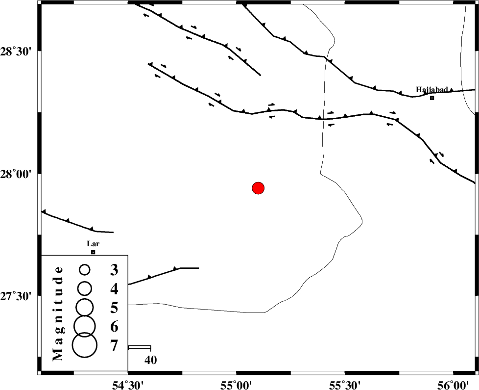
| Location | Lat:27.94 Lon: 55.1 |
| Region | Fars Province, 80 km North-East of Lar |
Nearest Cities |
|
| 31 km South of Fadami, Fars Province | |
| 33 km North West of Darz, Fars Province | |
| 42 km South West of Doborji, Fars Province | |
| 56 km South of Rostaq, Fars Province | |
| 67 km North East of Dehkuyeh, Fars Province | |
| Depth | 18 km |
| Agency | |
Faults within 150 km: |
|
| HZF2 (Length: 437 km) , Distance to epicenter: 34 km | |
| LAR_F (Length: 99 km) , Distance to epicenter: 45 km | |
| HZF1 (Length: 102 km) , Distance to epicenter: 51 km | |
| Number of Phases | 4 |
| RMS | 0 |
| Number of Stations | 3 |
| Error in Latitude | >1.6 km |
| Error in Longitude | 1.6 km |
| Error in Depth | 3.9 km |
Download waveform in seisan format
to download seisan software Click here
to access information about IIEES stations Click here
Amplitude | ||||||||
| UID | Agency | Station | Component | Amplitude | Period | Arrival Time | Proccessing Time | Signal Clip |
| 63800 | IIEES | BNDS | N | 1044.1 | 0.56 | 2010-06-07 00:58:14 | 2010-06-07 09:05:00 | n |
| 63801 | IIEES | KRBR | N | 236.2 | 0.56 | 2010-06-07 00:59:02 | 2010-06-07 09:05:00 | n |
| 63802 | IIEES | KRBR | E | 188.4 | 0.68 | 2010-06-07 00:59:06 | 2010-06-07 09:05:00 | n |
Phase | ||||||||||||
| Agency | Station | Component | Phase Type | Phase Quality | First Motion | Observed Arrival Time | Time Residual | Loc. Flag | Input Weight | Distance | Azimuth | |
| IIEES | BNDS | Z | Pg | E | 2010-06-07 00:57:53 | 0 | y | 122 | 119 | |||
| IIEES | GHIR | Z | Pg | E | 2010-06-07 00:58:07 | 0 | y | 211 | 281 | |||
| IIEES | KRBR | Z | Pn | E | 2010-06-07 00:58:15 | 0 | y | 278 | 35 | |||
| IIEES | KRBR | N | Sg | E | 2010-06-07 00:58:51 | 0 | y | 278 | 35 | |||