
Magnitude |
3.6 |
| Date & Time (UTC) | 2010-07-23 18:22:05.7 |
| Date & Time (Local) | 1389/5/1 22:52:05.7 |
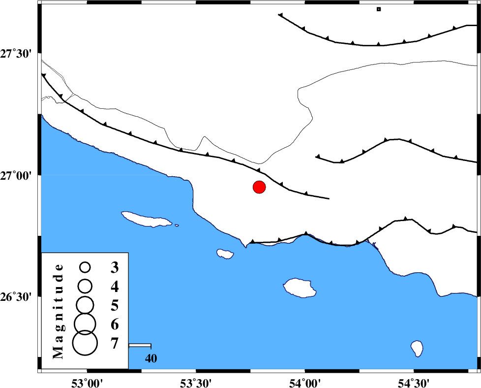
| Location | Lat:26.95 Lon: 53.79 |
| Region | Hormozgan Province, 64 km South-West of Bastak |
Nearest Cities |
|
| 25 km South of Ahl, Fars Province | |
| 35 km South East of Ashkenan, Fars Province | |
| 50 km West of Jenah, Hormozgan Province | |
| 59 km South East of Beyram, Fars Province | |
| 63 km South West of Bastak, Hormozgan Province | |
| Depth | 14 km |
| Agency | |
Faults within 150 km: |
|
| MFF3 (Length: 292 km) , Distance to epicenter: 7 km | |
| ZFF1 (Length: 165 km) , Distance to epicenter: 26 km | |
| MFF1 (Length: 180 km) , Distance to epicenter: 29 km | |
| Number of Phases | 4 |
| RMS | 0 |
| Number of Stations | 3 |
| Error in Latitude | >9.8 km |
| Error in Longitude | 5.2 km |
| Error in Depth | 11.6 km |
Download waveform in seisan format
to download seisan software Click here
to access information about IIEES stations Click here
Amplitude | ||||||||
| UID | Agency | Station | Component | Amplitude | Period | Arrival Time | Proccessing Time | Signal Clip |
| 66510 | IIEES | GHIR | N | 1281.1 | 0.56 | 2010-07-23 18:23:03 | 2010-07-23 06:43:00 | n |
| 66511 | IIEES | GHIR | E | 1115.8 | 0.8 | 2010-07-23 18:23:09 | 2010-07-23 06:43:00 | n |
| 66512 | IIEES | BNDS | E | 288.4 | 0.64 | 2010-07-23 18:23:25 | 2010-07-23 06:43:00 | n |
| 66513 | IIEES | BNDS | N | 324.5 | 0.64 | 2010-07-23 18:23:27 | 2010-07-23 06:43:00 | n |
Phase | ||||||||||||
| Agency | Station | Component | Phase Type | Phase Quality | First Motion | Observed Arrival Time | Time Residual | Loc. Flag | Input Weight | Distance | Azimuth | |
| IIEES | GHIR | Z | Pn | E | 2010-07-23 18:22:34 | 0 | y | 168 | 332 | |||
| IIEES | GHIR | N | Sg | E | 2010-07-23 18:22:53 | 0 | y | 168 | 332 | |||
| IIEES | BNDS | E | Pn | E | 2010-07-23 18:22:43 | 0 | y | 242 | 77 | |||
| IIEES | KRBR | Z | Pn | E | 2010-07-23 18:23:08 | 0 | y | 445 | 40 | |||