
Magnitude |
3.2 |
| Date & Time (UTC) | 2010-09-01 23:02:17.7 |
| Date & Time (Local) | 1389/6/11 03:32:17.7 |
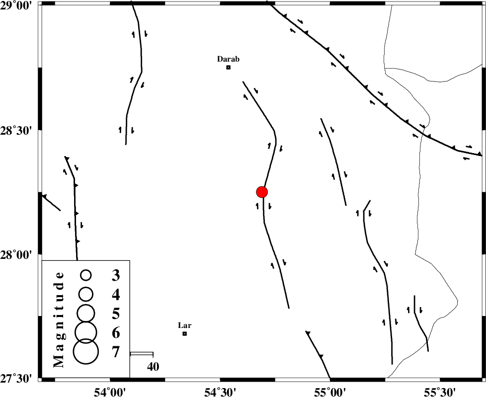
| Location | Lat:28.25 Lon: 54.69 |
| Region | Fars Province, 57 km South-East of Darab |
Nearest Cities |
|
| 29 km South East of Hajiabad, Fars Province | |
| 35 km East of Shahr-e pir, Fars Province | |
| 44 km South West of Rostaq, Fars Province | |
| 44 km South of Dehkheyr, Fars Province | |
| 49 km North West of Fadami, Fars Province | |
| Depth | 38 km |
| Agency | |
Faults within 150 km: |
|
| HZF2 (Length: 437 km) , Distance to epicenter: 14 km | |
| HZF1 (Length: 102 km) , Distance to epicenter: 37 km | |
| MAIN_ZAGROS_R_F (Length: 1106 km) , Distance to epicenter: 58 km | |
| Number of Phases | 7 |
| RMS | 0 |
| Number of Stations | 6 |
| Error in Latitude | >4.5 km |
| Error in Longitude | 2.2 km |
| Error in Depth | 2.4 km |
Download waveform in seisan format
to download seisan software Click here
to access information about IIEES stations Click here
Amplitude | ||||||||
| UID | Agency | Station | Component | Amplitude | Period | Arrival Time | Proccessing Time | Signal Clip |
| 69790 | IIEES | GHIR | N | 288.3 | 0.56 | 2010-09-01 23:03:14 | 2010-09-02 12:06:00 | n |
| 69791 | IIEES | GHIR | E | 274.1 | 0.52 | 2010-09-01 23:03:15 | 2010-09-02 12:06:00 | n |
| 69792 | IIEES | BNDS | N | 385.6 | 0.6 | 2010-09-01 23:03:07 | 2010-09-02 12:06:00 | n |
| 69793 | IIEES | BNDS | E | 340.9 | 0.48 | 2010-09-01 23:03:09 | 2010-09-02 12:06:00 | n |
| 69794 | IIEES | KRBR | E | 106.3 | 0.44 | 2010-09-01 23:03:40 | 2010-09-02 12:06:00 | n |
| 69795 | IIEES | KRBR | N | 110.9 | 0.56 | 2010-09-01 23:03:47 | 2010-09-02 12:06:00 | n |
Phase | ||||||||||||
| Agency | Station | Component | Phase Type | Phase Quality | First Motion | Observed Arrival Time | Time Residual | Loc. Flag | Input Weight | Distance | Azimuth | |
| IIEES | GHIR | Z | P | E | 2010-09-01 23:02:43 | 0 | y | 167 | 272 | |||
| IIEES | GHIR | N | Sg | E | 2010-09-01 23:03:05 | 0 | y | 167 | 272 | |||
| IIEES | KRBR | Z | P | E | 2010-09-01 23:02:58 | 0 | y | 278 | 46 | |||
| IIEES | KRBR | E | Sg | E | 2010-09-01 23:03:34 | 0 | y | 278 | 46 | |||
| IIEES | NASN | Z | P | E | 2010-09-01 23:03:29 | 0 | y | 535 | 341 | |||
| IIEES | TABS | Z | P | E | 2010-09-01 23:03:43 | 0.1 | y | 642 | 21 | |||
| IIEES | KHMZ | Z | P | E | 2010-09-01 23:03:57 | -0.1 | y | 757 | 325 | |||