
Magnitude |
3.4 |
| Date & Time (UTC) | 2010-11-08 18:31:35.5 |
| Date & Time (Local) | 1389/8/17 22:01:35.5 |
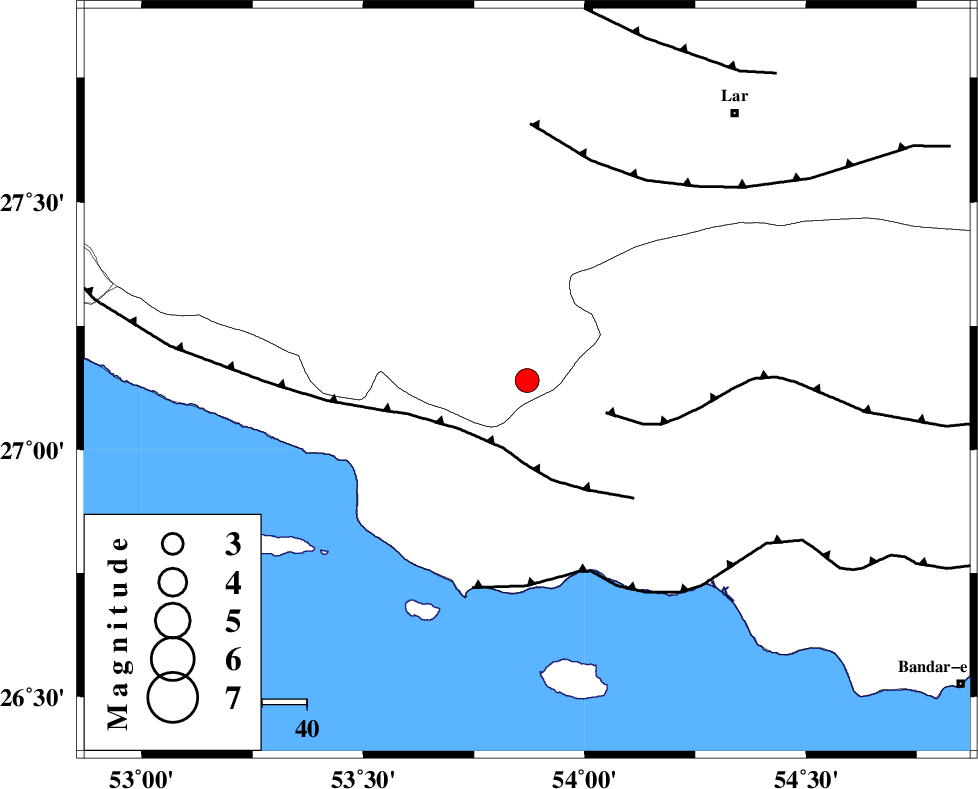
| Location | Lat:27.14 Lon: 53.87 |
| Region | Fars Province, 49 km West of Bastak |
Nearest Cities |
|
| 14 km East of Ahl, Fars Province | |
| 27 km East of Ashkenan, Fars Province | |
| 43 km South West of Bagh, Fars Province | |
| 43 km North West of Jenah, Hormozgan Province | |
| 47 km South East of Beyram, Fars Province | |
| Depth | 44 km |
| Agency | |
Faults within 150 km: |
|
| MFF3 (Length: 292 km) , Distance to epicenter: 16 km | |
| MFF1 (Length: 180 km) , Distance to epicenter: 19 km | |
| ZFF1 (Length: 165 km) , Distance to epicenter: 44 km | |
| Number of Phases | 5 |
| RMS | 0 |
| Number of Stations | 3 |
| Error in Latitude | >8.3 km |
| Error in Longitude | 4 km |
| Error in Depth | 4.4 km |
Download waveform in seisan format
to download seisan software Click here
to access information about IIEES stations Click here
Amplitude | ||||||||
| UID | Agency | Station | Component | Amplitude | Period | Arrival Time | Proccessing Time | Signal Clip |
| 73090 | IIEES | GHIR | N | 336.5 | 0.52 | 2010-11-08 18:32:32 | 2010-11-09 01:49:00 | n |
| 73091 | IIEES | GHIR | E | 327.8 | 0.52 | 2010-11-08 18:32:34 | 2010-11-09 01:49:00 | n |
| 73092 | IIEES | BNDS | E | 240.4 | 0.48 | 2010-11-08 18:32:48 | 2010-11-09 01:49:00 | n |
| 73093 | IIEES | BNDS | N | 279.1 | 0.48 | 2010-11-08 18:32:50 | 2010-11-09 01:49:00 | n |
| 73094 | IIEES | KRBR | N | 73.5 | 0.56 | 2010-11-08 18:33:41 | 2010-11-09 01:49:00 | n |
| 73095 | IIEES | KRBR | E | 73.9 | 0.6 | 2010-11-08 18:33:45 | 2010-11-09 01:49:00 | n |
Phase | ||||||||||||
| Agency | Station | Component | Phase Type | Phase Quality | First Motion | Observed Arrival Time | Time Residual | Loc. Flag | Input Weight | Distance | Azimuth | |
| IIEES | GHIR | Z | Pn | E | 2010-11-08 18:31:59 | -0.1 | y | 154 | 326 | |||
| IIEES | GHIR | N | Sg | E | 2010-11-08 18:32:19 | 0 | y | 154 | 326 | |||
| IIEES | BNDS | Z | Pn | E | 2010-11-08 18:32:09 | 0.1 | y | 229 | 82 | |||
| IIEES | BNDS | N | Sg | E | 2010-11-08 18:32:39 | 0 | y | 229 | 82 | |||
| IIEES | KRBR | Z | Pn | E | 2010-11-08 18:32:33 | 0 | y | 423 | 41 | |||