
Magnitude |
3.5 |
| Date & Time (UTC) | 2010-12-08 19:24:50.0 |
| Date & Time (Local) | 1389/9/17 22:54:50.0 |
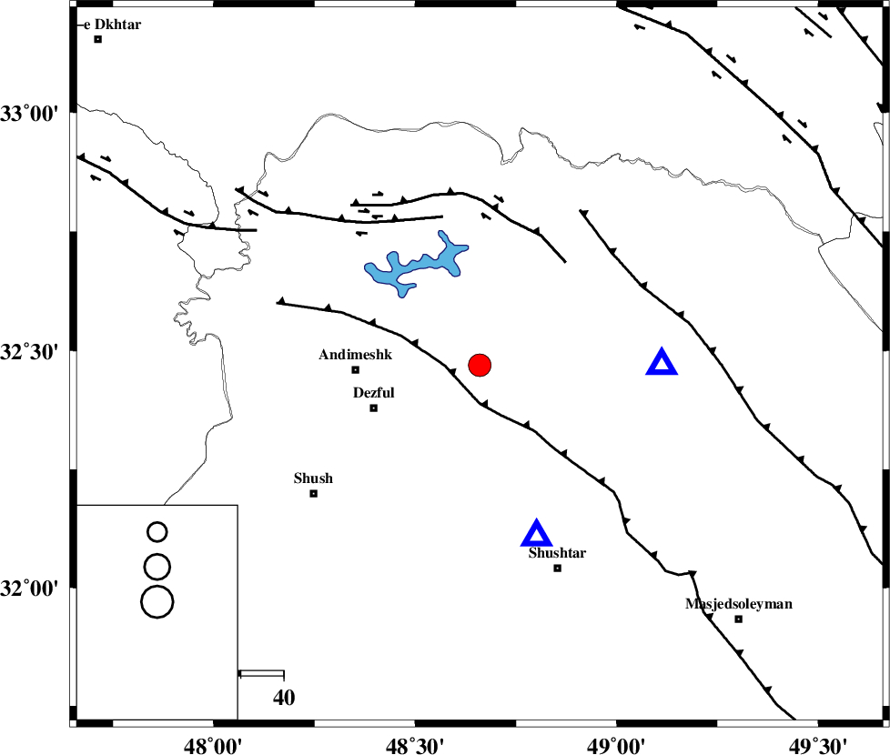
| Location | Lat:32.47 Lon: 48.66 |
| Region | Khoozestan Province, 29 km East of Andimeshk |
Nearest Cities |
|
| 8 km North of Mahur berenji, Khoozestan Province | |
| 17 km West of Sardasht, Khoozestan Province | |
| 27 km North East of Dezful, Khoozestan Province | |
| 29 km North West of Gatvand, Khoozestan Province | |
| 29 km North East of Shamsabad, Khoozestan Province | |
| Depth | 25 km |
| Agency | |
Faults within 150 km: |
|
| DEZFUL_EMBAYMENT (Length: 228 km) , Distance to epicenter: 8 km | |
| BALARUD_F_Z2 (Length: 58 km) , Distance to epicenter: 31 km | |
| BALARUD_F_Z3 (Length: 53 km) , Distance to epicenter: 36 km | |
| Number of Phases | 6 |
| RMS | 0.1 |
| Number of Stations | 6 |
| Error in Latitude | >2.5 km |
| Error in Longitude | 3.8 km |
| Error in Depth | 3.8 km |
Download waveform in seisan format
to download seisan software Click here
to access information about IIEES stations Click here
Amplitude | ||||||||
| UID | Agency | Station | Component | Amplitude | Period | Arrival Time | Proccessing Time | Signal Clip |
| 75250 | IIEES | KHMZ | E | 712.5 | 0.39 | 2010-12-08 19:25:51 | 2010-12-08 07:44:00 | n |
| 75251 | IIEES | KHMZ | N | 366.9 | 0.79 | 2010-12-08 19:25:51 | 2010-12-08 07:44:00 | n |
| 75252 | IIEES | ASAO | N | 253.5 | 0.67 | 2010-12-08 19:26:09 | 2010-12-08 07:44:00 | n |
| 75253 | IIEES | ASAO | E | 269.1 | 0.86 | 2010-12-08 19:26:12 | 2010-12-08 07:44:00 | n |
| 75254 | IIEES | SNGE | E | 132.7 | 1.14 | 2010-12-08 19:26:25 | 2010-12-08 07:44:00 | n |
| 75255 | IIEES | GHVR | E | 176 | 0.15 | 2010-12-08 19:26:36 | 2010-12-08 07:44:00 | n |
| 75256 | IIEES | NASN | N | 51.5 | 2.06 | 2010-12-08 19:26:53 | 2010-12-08 07:44:00 | n |
Phase | ||||||||||||
| Agency | Station | Component | Phase Type | Phase Quality | First Motion | Observed Arrival Time | Time Residual | Loc. Flag | Input Weight | Distance | Azimuth | |
| IIEES | SHGR | Z | Pg | E | 2010-12-08 19:24:58 | 0 | y | 42.2 | 162 | |||
| IIEES | KHMZ | Z | Pg | E | 2010-12-08 19:25:20 | 0 | y | 186 | 40 | |||
| IIEES | ASAO | Z | Pn | E | 2010-12-08 19:25:29 | -0.1 | y | 263 | 28 | |||
| IIEES | SNGE | Z | Pn | E | 2010-12-08 19:25:36 | 0.1 | y | 315 | 338 | |||
| IIEES | GHVR | Z | Pn | E | 2010-12-08 19:25:37 | -0.1 | y | 328 | 46 | |||
| IIEES | NASN | Z | Pn | E | 2010-12-08 19:25:45 | 0.1 | y | 391 | 84 | |||