
Magnitude |
3 |
| Date & Time (UTC) | 2010-12-21 12:51:39.8 |
| Date & Time (Local) | 1389/9/30 16:21:39.8 |
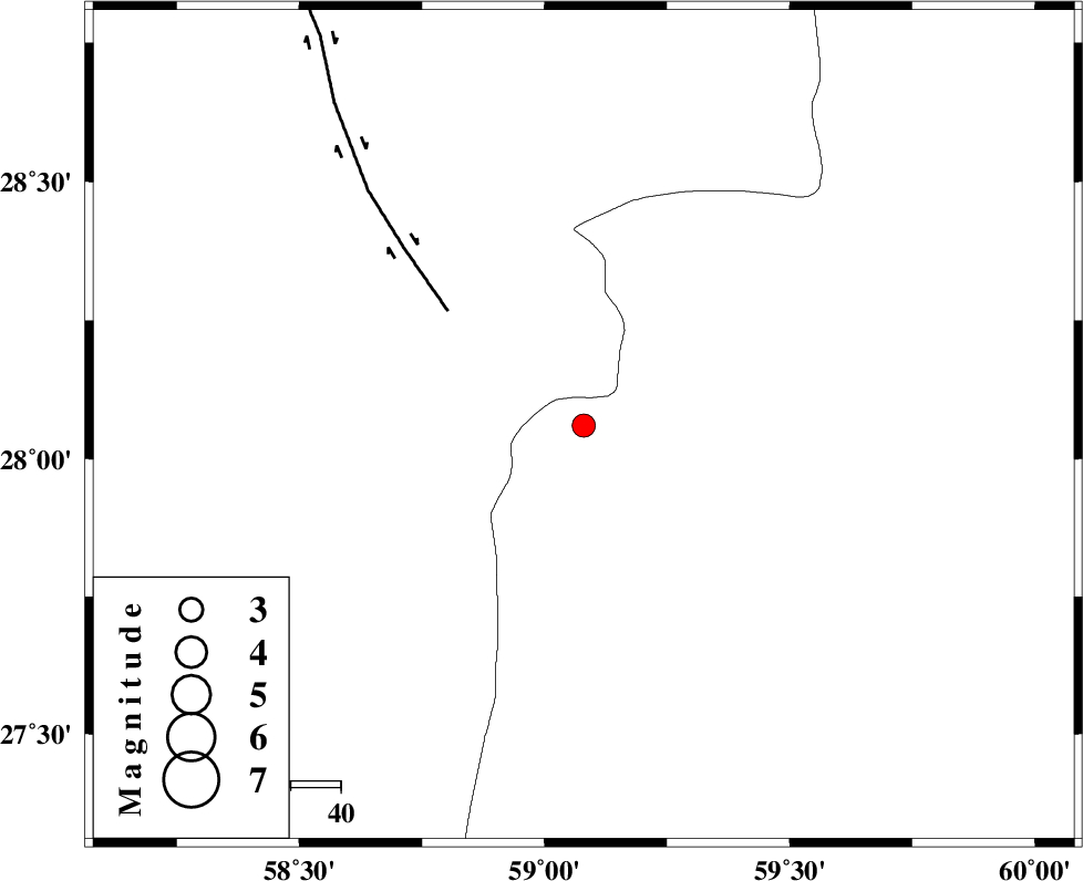
| Location | Lat:28.06 Lon: 59.08 |
| Region | Sistan va Baloochestan Province, 136 km North-East of Kahnuj |
Nearest Cities |
|
| 56 km North East of Borj-e abbasabad, Kerman Province | |
| 72 km South of Hoseynabad, Kerman Province | |
| 76 km South East of Mohammadabad-e gonbaki, Kerman Province | |
| 76 km North West of Kalemursi, Sistan va Baloochestan Province | |
| 92 km South East of Void, Kerman Province | |
| Depth | 46 km |
| Agency | |
Faults within 150 km: |
|
| BAM_F (Length: 118 km) , Distance to epicenter: 36 km | |
| KANURAK_F (Length: 135 km) , Distance to epicenter: 112 km | |
| KASKIN_F (Length: 100 km) , Distance to epicenter: 115 km | |
| Number of Phases | 6 |
| RMS | 0.3 |
| Number of Stations | 4 |
| Error in Latitude | >5.5 km |
| Error in Longitude | 4 km |
| Error in Depth | 8 km |
Download waveform in seisan format
to download seisan software Click here
to access information about IIEES stations Click here
Amplitude | ||||||||
| UID | Agency | Station | Component | Amplitude | Period | Arrival Time | Proccessing Time | Signal Clip |
| 75930 | IIEES | BNDS | E | 91.3 | 0.73 | 2010-12-21 12:53:05 | 2010-12-21 01:14:00 | n |
| 75931 | IIEES | BNDS | N | 143.3 | 0.87 | 2010-12-21 12:53:06 | 2010-12-21 01:14:00 | n |
| 75932 | IIEES | CHBR | E | 32.4 | 1.45 | 2010-12-21 12:53:03 | 2010-12-21 01:14:00 | n |
| 75933 | IIEES | KRBR | N | 53.6 | 0.63 | 2010-12-21 12:53:08 | 2010-12-21 01:14:00 | n |
| 75934 | IIEES | KRBR | E | 40.2 | 0.14 | 2010-12-21 12:53:08 | 2010-12-21 01:14:00 | n |
Phase | ||||||||||||
| Agency | Station | Component | Phase Type | Phase Quality | First Motion | Observed Arrival Time | Time Residual | Loc. Flag | Input Weight | Distance | Azimuth | |
| IIEES | ZHSF | Z | Pg | E | 2010-12-21 12:52:18 | -0.1 | y | 239 | 44 | |||
| IIEES | ZHSF | N | Sg | E | 2010-12-21 12:52:46 | 0.1 | y | 239 | 44 | |||
| IIEES | BNDS | Z | Pn | E | 2010-12-21 12:52:20 | -0.6 | y | 296 | 256 | |||
| IIEES | BNDS | N | Sg | E | 2010-12-21 12:53:01 | 0.2 | y | 296 | 256 | |||
| IIEES | CHBR | Z | Pn | E | 2010-12-21 12:52:22 | 0.2 | y | 307 | 153 | |||
| IIEES | KRBR | Z | Pn | E | 2010-12-21 12:52:23 | 0.2 | y | 310 | 314 | |||