
Magnitude |
3.3 |
| Date & Time (UTC) | 2010-12-28 08:09:36.0 |
| Date & Time (Local) | 1389/10/7 11:39:36.0 |
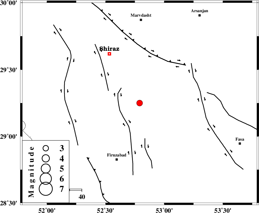
| Location | Lat:29.25 Lon: 52.79 |
| Region | Fars Province, 51 km North-East of Firuz Abad |
Nearest Cities |
|
| 2 km North of Akbarabad, Fars Province | |
| 8 km North of Kavar, Fars Province | |
| 9 km of Tasuj, Fars Province | |
| 11 km of Maharlu, Fars Province | |
| 13 km North of Ali Abad, Fars Province | |
| Depth | 14 km |
| Agency | |
Faults within 150 km: |
|
| SABZ_PUSHAN_F_Z1 (Length: 69 km) , Distance to epicenter: 17 km | |
| SABZ_PUSHAN_F_Z3 (Length: 37 km) , Distance to epicenter: 28 km | |
| SABZ_PUSHAN_F_Z2 (Length: 24 km) , Distance to epicenter: 30 km | |
| Number of Phases | 5 |
| RMS | 0.4 |
| Number of Stations | 4 |
| Error in Latitude | >10 km |
| Error in Longitude | 6.2 km |
| Error in Depth | 19.5 km |
Download waveform in seisan format
to download seisan software Click here
to access information about IIEES stations Click here
Amplitude | ||||||||
| UID | Agency | Station | Component | Amplitude | Period | Arrival Time | Proccessing Time | Signal Clip |
| 76593 | IIEES | GHIR | N | 646.4 | 0.52 | 2010-12-28 08:10:21 | 2010-12-28 08:25:00 | n |
| 76594 | IIEES | GHIR | E | 726.4 | 0.56 | 2010-12-28 08:10:23 | 2010-12-28 08:25:00 | n |
| 76595 | IIEES | AHRM | N | 257.9 | 0.66 | 2010-12-28 08:10:30 | 2010-12-28 08:25:00 | n |
| 76596 | IIEES | KRBR | E | 92.9 | 0.62 | 2010-12-28 08:11:32 | 2010-12-28 08:25:00 | n |
| 76597 | IIEES | KRBR | N | 64.1 | 0.62 | 2010-12-28 08:11:36 | 2010-12-28 08:25:00 | n |
Phase | ||||||||||||
| Agency | Station | Component | Phase Type | Phase Quality | First Motion | Observed Arrival Time | Time Residual | Loc. Flag | Input Weight | Distance | Azimuth | |
| IIEES | GHIR | Z | Pg | E | 2010-12-28 08:09:54 | 0.4 | y | 109 | 170 | |||
| IIEES | AHRM | Z | Pg | E | 2010-12-28 08:10:00 | -0.5 | y | 151 | 254 | |||
| IIEES | KRBR | Z | Pn | E | 2010-12-28 08:10:32 | -0.2 | y | 393 | 77 | |||
| IIEES | KRBR | N | Sg | E | 2010-12-28 08:11:25 | -0.3 | y | 393 | 77 | |||
| IIEES | NASN | Z | Pn | E | 2010-12-28 08:10:33 | 0.6 | y | 393 | 0 | |||