
Magnitude |
3.2 |
| Date & Time (UTC) | 2011-01-06 13:29:02.8 |
| Date & Time (Local) | 1389/10/16 16:59:02.8 |
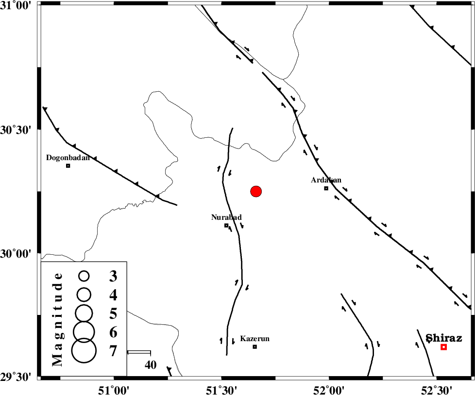
| Location | Lat:30.25 Lon: 51.66 |
| Region | Fars Province, 20 km North-East of Nurabad |
Nearest Cities |
|
| 14 km North East of Masiri, Fars Province | |
| 20 km North East of Nurabad, Fars Province | |
| 20 km North East of Fahlian-e olia, Fars Province | |
| 22 km North East of Gachgaran, Fars Province | |
| 27 km East of Dehnumoqimi, Fars Province | |
| Depth | 37 km |
| Agency | |
Faults within 150 km: |
|
| KAZERUN_F (Length: 96 km) , Distance to epicenter: 14 km | |
| HZF3 (Length: 197 km) , Distance to epicenter: 30 km | |
| MISHAN_F (Length: 76 km) , Distance to epicenter: 36 km | |
| Number of Phases | 5 |
| RMS | 0.1 |
| Number of Stations | 3 |
| Error in Latitude | >2.6 km |
| Error in Longitude | 3.5 km |
| Error in Depth | 5.4 km |
Download waveform in seisan format
to download seisan software Click here
to access information about IIEES stations Click here
Amplitude | ||||||||
| UID | Agency | Station | Component | Amplitude | Period | Arrival Time | Proccessing Time | Signal Clip |
| 76930 | IIEES | AHRM | E | 263.9 | 0.36 | 2011-01-06 13:29:50 | 2011-01-06 01:54:00 | n |
| 76931 | IIEES | AHRM | N | 414.5 | 0.36 | 2011-01-06 13:29:50 | 2011-01-06 01:54:00 | n |
| 76932 | IIEES | GHIR | E | 180.3 | 0.4 | 2011-01-06 13:30:17 | 2011-01-06 01:54:00 | n |
| 76933 | IIEES | GHIR | N | 145.2 | 0.44 | 2011-01-06 13:30:25 | 2011-01-06 01:54:00 | n |
Phase | ||||||||||||
| Agency | Station | Component | Phase Type | Phase Quality | First Motion | Observed Arrival Time | Time Residual | Loc. Flag | Input Weight | Distance | Azimuth | |
| IIEES | AHRM | Z | Pn | E | 2011-01-06 13:29:27 | -0.1 | y | 157 | 193 | |||
| IIEES | AHRM | N | Sg | E | 2011-01-06 13:29:47 | 0.1 | y | 157 | 193 | |||
| IIEES | GHIR | Z | Pn | E | 2011-01-06 13:29:39 | 0.2 | y | 253 | 149 | |||
| IIEES | GHIR | N | Sg | E | 2011-01-06 13:30:12 | -0.1 | y | 253 | 149 | |||
| IIEES | NASN | Z | Pn | E | 2011-01-06 13:29:46 | 0 | y | 303 | 21 | |||