
Magnitude |
3.3 |
| Date & Time (UTC) | 2011-01-06 23:16:50.2 |
| Date & Time (Local) | 1389/10/17 02:46:50.2 |
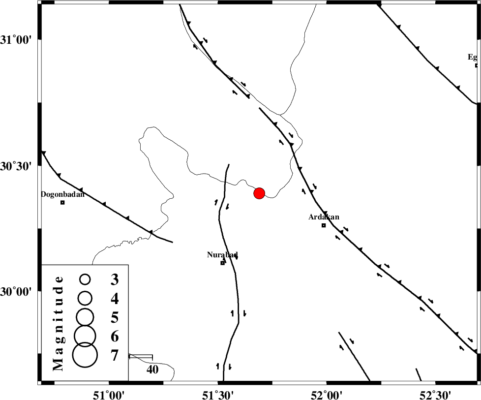
| Location | Lat:30.39 Lon: 51.69 |
| Region | Fars Province, 33 km South-East of Yasuj |
Nearest Cities |
|
| 19 km West of Kamhar, Fars Province | |
| 24 km North East of Masiri, Fars Province | |
| 26 km South East of Hoseynabad, Kohkiluieh va boyerahmad Province | |
| 26 km South East of Tal-e khosro, Kohkiluieh va boyerahmad Province | |
| 30 km North East of Dehnumoqimi, Fars Province | |
| Depth | 15 km |
| Agency | |
Faults within 150 km: |
|
| KAZERUN_F (Length: 96 km) , Distance to epicenter: 15 km | |
| HZF3 (Length: 197 km) , Distance to epicenter: 21 km | |
| DENA_F (Length: 137 km) , Distance to epicenter: 42 km | |
| Number of Phases | 4 |
| RMS | 0.3 |
| Number of Stations | 5 |
| Error in Latitude | >3.8 km |
| Error in Longitude | 7.3 km |
| Error in Depth | 0 km |
Download waveform in seisan format
to download seisan software Click here
to access information about IIEES stations Click here
Amplitude | ||||||||
| UID | Agency | Station | Component | Amplitude | Period | Arrival Time | Proccessing Time | Signal Clip |
| 76940 | IIEES | AHRM | N | 413.4 | 0.52 | 2011-01-06 23:17:44 | 2011-01-07 01:01:00 | n |
| 76941 | IIEES | AHRM | E | 291.7 | 0.72 | 2011-01-06 23:17:50 | 2011-01-07 01:01:00 | n |
| 76942 | IIEES | GHIR | N | 171.6 | 0.6 | 2011-01-06 23:18:23 | 2011-01-07 01:01:00 | n |
| 76943 | IIEES | GHIR | E | 166.5 | 0.72 | 2011-01-06 23:18:25 | 2011-01-07 01:01:00 | n |
| 76944 | IIEES | SHGR | N | 92 | 0.52 | 2011-01-06 23:18:40 | 2011-01-07 01:01:00 | n |
| 76945 | IIEES | SHGR | E | 147.1 | 0.64 | 2011-01-06 23:19:01 | 2011-01-07 01:01:00 | n |
Phase | ||||||||||||
| Agency | Station | Component | Phase Type | Phase Quality | First Motion | Observed Arrival Time | Time Residual | Loc. Flag | Input Weight | Distance | Azimuth | |
| IIEES | AHRM | Z | Pn | E | 2011-01-06 23:17:19 | 0.2 | y | 174 | 193 | |||
| IIEES | GHIR | Z | Pn | E | 2011-01-06 23:17:30 | -0.3 | y | 266 | 151 | |||
| IIEES | NASN | Z | Pn | E | 2011-01-06 23:17:33 | 0.3 | y | 287 | 21 | |||
| IIEES | KHMZ | Z | Pn | E | 2011-01-06 23:17:48 | -0.3 | y | 405 | 337 | |||