
Magnitude |
3.4 |
| Date & Time (UTC) | 2011-01-08 11:31:52.4 |
| Date & Time (Local) | 1389/10/18 15:01:52.4 |
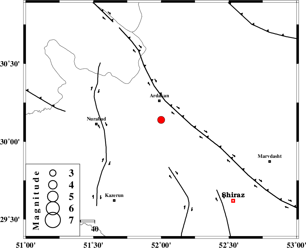
| Location | Lat:30.14 Lon: 52 |
| Region | Fars Province, 14 km South of Ardakan |
Nearest Cities |
|
| 9 km of Bahrghan, Fars Province | |
| 14 km South of Ardakan, Fars Province | |
| 36 km South East of Kamhar, Fars Province | |
| 40 km North West of Banesh, Fars Province | |
| 42 km West of Dorudzan, Fars Province | |
| Depth | 15 km |
| Agency | |
Faults within 150 km: |
|
| HZF3 (Length: 197 km) , Distance to epicenter: 14 km | |
| KAREBASS_F (Length: 98 km) , Distance to epicenter: 34 km | |
| KAZERUN_F (Length: 96 km) , Distance to epicenter: 41 km | |
| Number of Phases | 3 |
| RMS | 0 |
| Number of Stations | 3 |
| Error in Latitude | >1.5 km |
| Error in Longitude | 3.5 km |
| Error in Depth | 0 km |
Download waveform in seisan format
to download seisan software Click here
to access information about IIEES stations Click here
Amplitude | ||||||||
| UID | Agency | Station | Component | Amplitude | Period | Arrival Time | Proccessing Time | Signal Clip |
| 77010 | IIEES | AHRM | N | 833.3 | 1.08 | 2011-01-08 11:32:41 | 2011-01-08 06:12:00 | n |
| 77011 | IIEES | AHRM | E | 564.1 | 1.19 | 2011-01-08 11:32:42 | 2011-01-08 06:12:00 | n |
| 77012 | IIEES | GHIR | N | 270.5 | 0.83 | 2011-01-08 11:33:14 | 2011-01-08 06:12:00 | n |
| 77013 | IIEES | GHIR | E | 238.3 | 0.14 | 2011-01-08 11:33:15 | 2011-01-08 06:12:00 | n |
Phase | ||||||||||||
| Agency | Station | Component | Phase Type | Phase Quality | First Motion | Observed Arrival Time | Time Residual | Loc. Flag | Input Weight | Distance | Azimuth | |
| IIEES | AHRM | Z | Pg | E | 2011-01-08 11:32:18 | 0 | y | 157 | 206 | |||
| IIEES | GHIR | Z | Pg | E | 2011-01-08 11:32:29 | 0 | y | 227 | 155 | |||
| IIEES | NASN | Z | Pn | E | 2011-01-08 11:32:38 | 0 | y | 305 | 14 | |||