
Magnitude |
3 |
| Date & Time (UTC) | 2011-01-24 08:23:29.3 |
| Date & Time (Local) | 1389/11/4 11:53:29.3 |
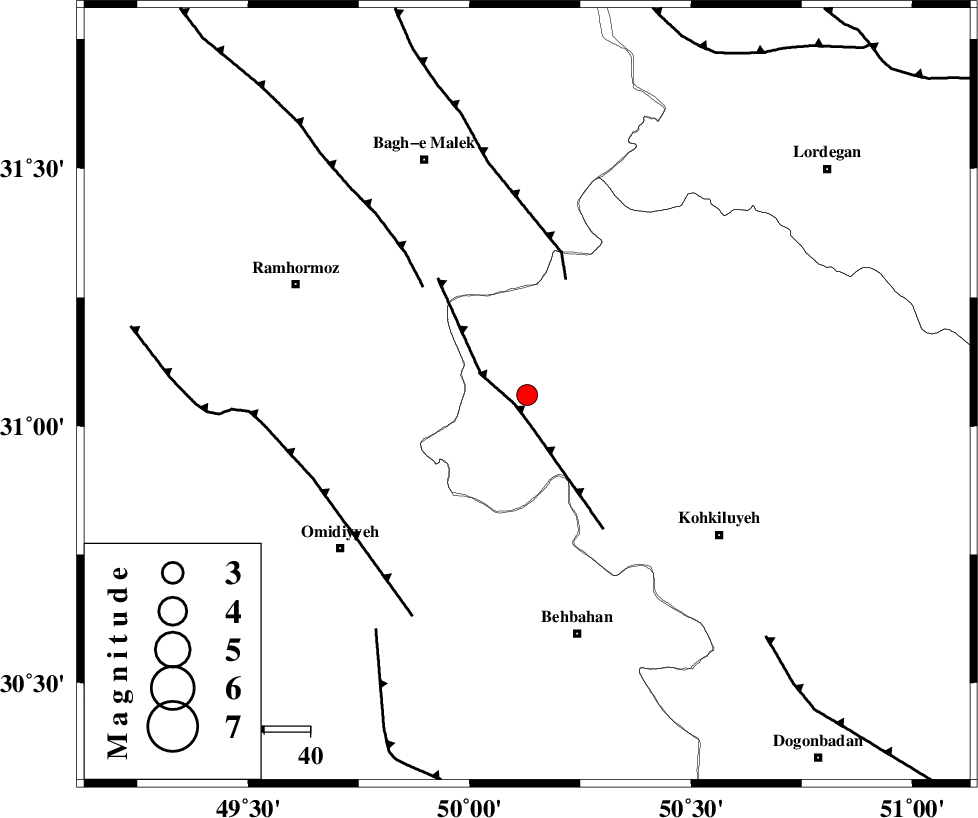
| Location | Lat:31.06 Lon: 50.13 |
| Region | Kohkiluieh va boyerahmad Province, 53 km North-West of Behbahan |
Nearest Cities |
|
| 29 km South West of Esfandan, Kohkiluieh va boyerahmad Province | |
| 30 km North West of Lendeh, Kohkiluieh va boyerahmad Province | |
| 33 km South West of Qale-ye raiesi, Kohkiluieh va boyerahmad Province | |
| 34 km South of Seidun, Khoozestan Province | |
| 34 km North East of Jayzan, Khoozestan Province | |
| Depth | 14 km |
| Agency | |
Faults within 150 km: |
|
| MFF4 (Length: 62 km) , Distance to epicenter: 3 km | |
| MFF2 (Length: 205 km) , Distance to epicenter: 26 km | |
| DEZFUL_EMBAYMENT (Length: 228 km) , Distance to epicenter: 32 km | |
| Number of Phases | 6 |
| RMS | 0.1 |
| Number of Stations | 5 |
| Error in Latitude | >4 km |
| Error in Longitude | 5.4 km |
| Error in Depth | 7.7 km |
Download waveform in seisan format
to download seisan software Click here
to access information about IIEES stations Click here
Amplitude | ||||||||
| UID | Agency | Station | Component | Amplitude | Period | Arrival Time | Proccessing Time | Signal Clip |
| 77323 | IIEES | SHGR | E | 389.6 | 0.38 | 2011-01-24 08:24:21 | 2011-01-24 08:48:00 | n |
| 77324 | IIEES | SHGR | N | 406.4 | 0.38 | 2011-01-24 08:24:21 | 2011-01-24 08:48:00 | n |
| 77325 | IIEES | KHMZ | E | 29.1 | 0.56 | 2011-01-24 08:24:56 | 2011-01-24 08:48:00 | n |
| 77326 | IIEES | ASAO | N | 14.9 | 0.81 | 2011-01-24 08:25:33 | 2011-01-24 08:48:00 | n |
Phase | ||||||||||||
| Agency | Station | Component | Phase Type | Phase Quality | First Motion | Observed Arrival Time | Time Residual | Loc. Flag | Input Weight | Distance | Azimuth | |
| IIEES | SHGR | Z | Pg | E | 2011-01-24 08:23:57 | 0 | y | 171 | 313 | |||
| IIEES | KHMZ | Z | Pn | E | 2011-01-24 08:24:13 | -0.1 | y | 297 | 357 | |||
| IIEES | KHMZ | E | Sg | E | 2011-01-24 08:24:52 | 0 | y | 297 | 357 | |||
| IIEES | NASN | Z | Pn | E | 2011-01-24 08:24:16 | -0.1 | y | 318 | 52 | |||
| IIEES | ASAO | Z | Pn | E | 2011-01-24 08:24:25 | 0 | y | 387 | 359 | |||
| IIEES | GHVR | Z | Pn | E | 2011-01-24 08:24:26 | 0.2 | y | 393 | 15 | |||