
Magnitude |
3.1 |
| Date & Time (UTC) | 2011-02-06 18:51:08.4 |
| Date & Time (Local) | 1389/11/17 22:21:08.4 |
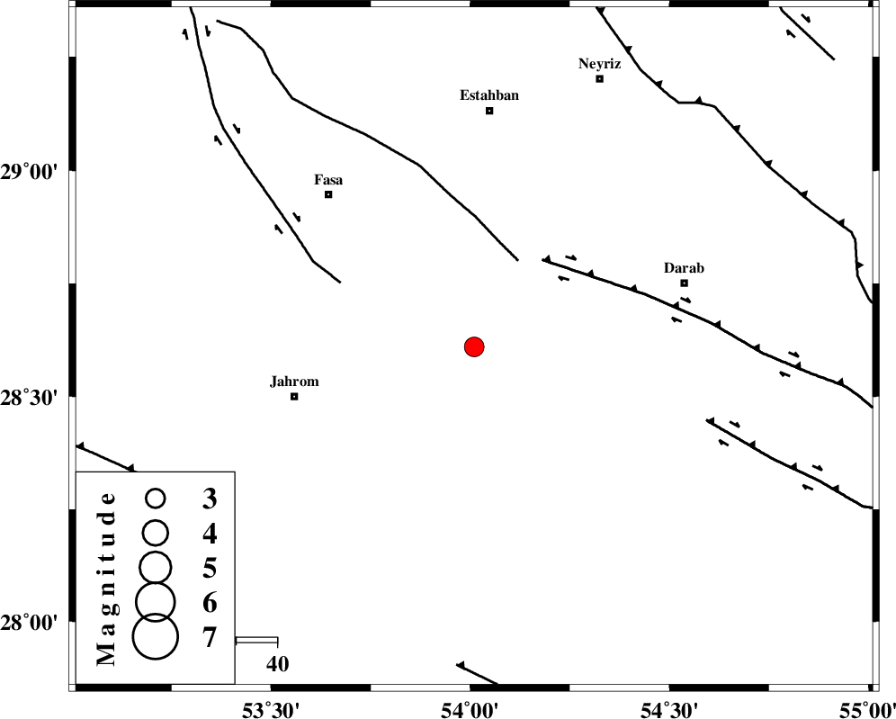
| Location | Lat:28.61 Lon: 54.01 |
| Region | Fars Province, 58 km South of Estahban |
Nearest Cities |
|
| 22 km South East of Miyandeh, Fars Province | |
| 25 km South East of Zahedshahr, Fars Province | |
| 27 km North East of Alaviyeh, Fars Province | |
| 29 km North West of Dabiran, Fars Province | |
| 30 km South West of Madoan, Fars Province | |
| Depth | 14 km |
| Agency | |
Faults within 150 km: |
|
| BAKHTEGAN_F (Length: 94 km) , Distance to epicenter: 24 km | |
| HZF1 (Length: 102 km) , Distance to epicenter: 27 km | |
| SARVESTAN_F (Length: 94 km) , Distance to epicenter: 36 km | |
| Number of Phases | 4 |
| RMS | 0.1 |
| Number of Stations | 3 |
| Error in Latitude | >4.9 km |
| Error in Longitude | 3.3 km |
| Error in Depth | 6 km |
Download waveform in seisan format
to download seisan software Click here
to access information about IIEES stations Click here
Amplitude | ||||||||
| UID | Agency | Station | Component | Amplitude | Period | Arrival Time | Proccessing Time | Signal Clip |
| 77828 | IIEES | GHIR | N | 753.1 | 0.2 | 2011-02-06 18:51:43 | 2011-02-06 07:29:00 | n |
| 77829 | IIEES | GHIR | E | 769.4 | 0.48 | 2011-02-06 18:51:43 | 2011-02-06 07:29:00 | n |
| 77830 | IIEES | KRBR | N | 57.1 | 0.56 | 2011-02-06 18:52:41 | 2011-02-06 07:29:00 | n |
| 77831 | IIEES | KRBR | E | 51.6 | 0.4 | 2011-02-06 18:52:43 | 2011-02-06 07:29:00 | n |
Phase | ||||||||||||
| Agency | Station | Component | Phase Type | Phase Quality | First Motion | Observed Arrival Time | Time Residual | Loc. Flag | Input Weight | Distance | Azimuth | |
| IIEES | GHIR | Z | Pg | E | 2011-02-06 18:51:26 | 0 | y | 107 | 251 | |||
| IIEES | BNDS | Z | Pn | E | 2011-02-06 18:51:47 | 0 | y | 251 | 122 | |||
| IIEES | KRBR | Z | Pn | E | 2011-02-06 18:51:54 | 0.1 | y | 307 | 60 | |||
| IIEES | KRBR | N | Sg | E | 2011-02-06 18:52:34 | -0.1 | y | 307 | 60 | |||