
Magnitude |
3.3 |
| Date & Time (UTC) | 2011-03-02 00:40:08.7 |
| Date & Time (Local) | 1389/12/11 04:10:08.7 |
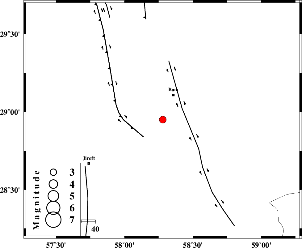
| Location | Lat:28.95 Lon: 58.28 |
| Region | Kerman Province, 19 km South of Bam |
Nearest Cities |
|
| 16 km West of Baravat, Kerman Province | |
| 19 km South of Bam, Kerman Province | |
| 23 km North West of Kruk, Kerman Province | |
| 23 km South West of Poshtrud, Kerman Province | |
| 29 km North West of Abshur-e nezamabad, Kerman Province | |
| Depth | 14 km |
| Agency | |
Faults within 150 km: |
|
| BAM_F (Length: 118 km) , Distance to epicenter: 16 km | |
| GOWK_F (Length: 152 km) , Distance to epicenter: 18 km | |
| SABZEVARAN_F (Length: 190 km) , Distance to epicenter: 64 km | |
| Number of Phases | 4 |
| RMS | 0.1 |
| Number of Stations | 4 |
| Error in Latitude | >6.6 km |
| Error in Longitude | 9 km |
| Error in Depth | 12.2 km |
Download waveform in seisan format
to download seisan software Click here
to access information about IIEES stations Click here
Amplitude | ||||||||
| UID | Agency | Station | Component | Amplitude | Period | Arrival Time | Proccessing Time | Signal Clip |
| 78186 | IIEES | BNDS | E | 154.5 | 0.23 | 2011-03-02 00:41:26 | 2011-03-02 12:58:00 | n |
| 78187 | IIEES | BNDS | N | 129.7 | 0.7 | 2011-03-02 00:41:29 | 2011-03-02 12:58:00 | n |
| 78188 | IIEES | GHIR | N | 25 | 0.63 | 2011-03-02 00:42:20 | 2011-03-02 12:58:00 | n |
| 78189 | IIEES | GHIR | E | 22.8 | 0.98 | 2011-03-02 00:42:23 | 2011-03-02 12:58:00 | n |
Phase | ||||||||||||
| Agency | Station | Component | Phase Type | Phase Quality | First Motion | Observed Arrival Time | Time Residual | Loc. Flag | Input Weight | Distance | Azimuth | |
| IIEES | KRBR | Z | Pg | E | 2011-03-02 00:40:39 | 0 | y | 187 | 308 | |||
| IIEES | BNDS | Z | Pn | E | 2011-03-02 00:40:49 | 0 | y | 269 | 231 | |||
| IIEES | GHIR | Z | Pn | E | 2011-03-02 00:41:21 | 0.1 | y | 523 | 263 | |||
| IIEES | SHRT | Z | Pn | E | 2011-03-02 00:41:25 | 0 | y | 555 | 20 | |||