
Magnitude |
3.2 |
| Date & Time (UTC) | 2011-03-05 03:44:52.5 |
| Date & Time (Local) | 1389/12/14 07:14:52.5 |
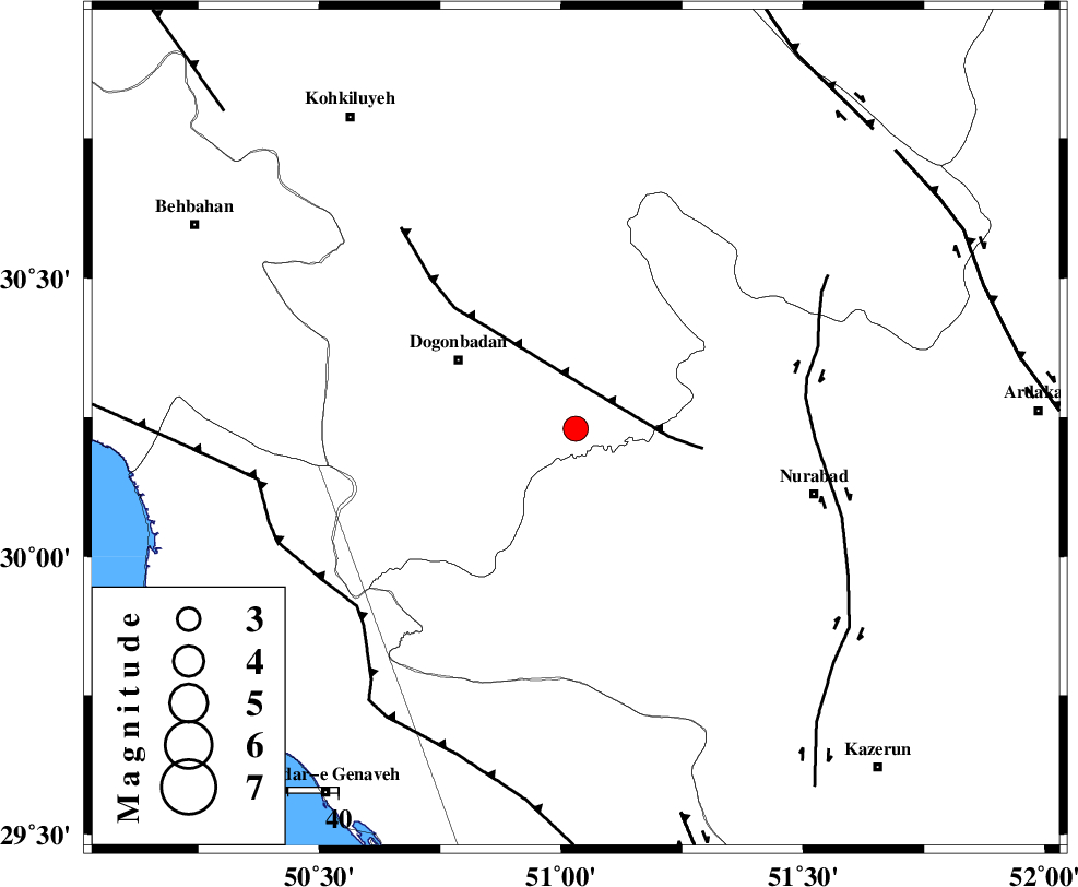
| Location | Lat:30.23 Lon: 51.03 |
| Region | Kohkiluieh va boyerahmad Province, 27 km South-East of Dogonbadan |
Nearest Cities |
|
| 19 km South West of Basht, Kohkiluieh va boyerahmad Province | |
| 24 km North West of Babamonir, Fars Province | |
| 25 km South of Abdehgah, Kohkiluieh va boyerahmad Province | |
| 27 km South East of Dogonbadan, Kohkiluieh va boyerahmad Province | |
| 28 km South West of Kopon olia, Fars Province | |
| Depth | 18 km |
| Agency | |
Faults within 150 km: |
|
| MISHAN_F (Length: 76 km) , Distance to epicenter: 8 km | |
| KAZERUN_F (Length: 96 km) , Distance to epicenter: 46 km | |
| ZFF3 (Length: 125 km) , Distance to epicenter: 56 km | |
| Number of Phases | 4 |
| RMS | 0.1 |
| Number of Stations | 3 |
| Error in Latitude | >3 km |
| Error in Longitude | 5.8 km |
| Error in Depth | 7.7 km |
Download waveform in seisan format
to download seisan software Click here
to access information about IIEES stations Click here
Amplitude | ||||||||
| UID | Agency | Station | Component | Amplitude | Period | Arrival Time | Proccessing Time | Signal Clip |
| 78229 | IIEES | GHIR | E | 88.6 | 0.68 | 2011-03-05 03:46:30 | 2011-03-05 04:13:00 | n |
| 78230 | IIEES | GHIR | N | 71.4 | 0.6 | 2011-03-05 03:46:31 | 2011-03-05 04:13:00 | n |
| 78231 | IIEES | SNGE | E | 8.3 | 0.2 | 2011-03-05 03:47:29 | 2011-03-05 04:13:00 | n |
| 78232 | IIEES | SNGE | N | 11.8 | 0.36 | 2011-03-05 03:47:33 | 2011-03-05 04:13:00 | n |
Phase | ||||||||||||
| Agency | Station | Component | Phase Type | Phase Quality | First Motion | Observed Arrival Time | Time Residual | Loc. Flag | Input Weight | Distance | Azimuth | |
| IIEES | GHIR | Z | P | E | 2011-03-05 03:45:35 | -0.1 | y | 288 | 138 | |||
| IIEES | GHIR | E | Sg | E | 2011-03-05 03:46:13 | 0 | y | 288 | 138 | |||
| IIEES | NASN | Z | Pn | E | 2011-03-05 03:45:41 | 0 | y | 331 | 30 | |||
| IIEES | SNGE | Z | Pn | E | 2011-03-05 03:46:19 | 0.1 | y | 640 | 328 | |||