
Magnitude |
3.6 |
| Date & Time (UTC) | 2011-03-14 09:12:31.0 |
| Date & Time (Local) | 1389/12/23 12:42:31.0 |
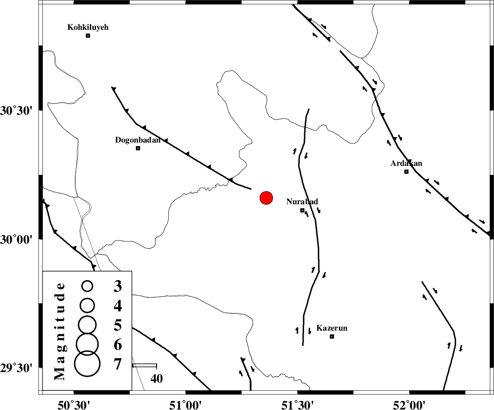
| Location | Lat:30.16 Lon: 51.36 |
| Region | Fars Province, 16 km West of Nurabad |
Nearest Cities |
|
| 8 km North of Ahangari, Fars Province | |
| 10 km of Fahlian-e olia, Fars Province | |
| 16 km North West of Nurabad, Fars Province | |
| 17 km South of Dehnumoqimi, Fars Province | |
| 17 km West of Masiri, Fars Province | |
| Depth | 15 km |
| Agency | |
Faults within 150 km: |
|
| MISHAN_F (Length: 76 km) , Distance to epicenter: 7 km | |
| KAZERUN_F (Length: 96 km) , Distance to epicenter: 17 km | |
| HZF3 (Length: 197 km) , Distance to epicenter: 61 km | |
| Number of Phases | 6 |
| RMS | 0.2 |
| Number of Stations | 6 |
| Error in Latitude | >10.7 km |
| Error in Longitude | 2.6 km |
| Error in Depth | 0 km |
Download waveform in seisan format
to download seisan software Click here
to access information about IIEES stations Click here
Amplitude | ||||||||
| UID | Agency | Station | Component | Amplitude | Period | Arrival Time | Proccessing Time | Signal Clip |
| 78299 | IIEES | SHGR | E | 440.4 | 0.73 | 2011-03-14 09:14:14 | 2011-03-14 09:27:00 | n |
| 78300 | IIEES | KHMZ | N | 50.6 | 0.49 | 2011-03-14 09:14:24 | 2011-03-14 09:27:00 | n |
Phase | ||||||||||||
| Agency | Station | Component | Phase Type | Phase Quality | First Motion | Observed Arrival Time | Time Residual | Loc. Flag | Input Weight | Distance | Azimuth | |
| IIEES | NASN | Z | Pn | E | 2011-03-14 09:13:19 | 0.2 | y | 324 | 25 | |||
| IIEES | SHGR | Z | Pn | E | 2011-03-14 09:13:19 | 0 | y | 327 | 312 | |||
| IIEES | KHMZ | Z | Pn | E | 2011-03-14 09:13:30 | 0.2 | y | 419 | 342 | |||
| IIEES | GHVR | Z | Pn | E | 2011-03-14 09:13:38 | -0.2 | y | 480 | 359 | |||
| IIEES | ASAO | Z | Pn | E | 2011-03-14 09:13:41 | -0.2 | y | 503 | 346 | |||
| IIEES | TABS | Z | Pn | E | 2011-03-14 09:14:01 | -0.1 | y | 668 | 53 | |||