
Magnitude |
2.6 |
| Date & Time (UTC) | 2011-03-28 23:56:45.4 |
| Date & Time (Local) | 1390/1/9 04:26:45.4 |
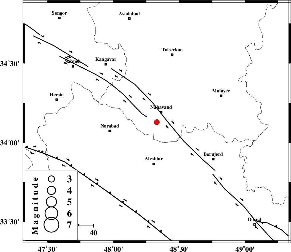
| Location | Lat:34.13 Lon: 48.33 |
| Region | Hamedan Province, 8 km Nahavand |
Nearest Cities |
|
| 8 km of Nahavand, Hamedan Province | |
| 9 km of Gian, Hamedan Province | |
| 12 km South of Dehghul, Hamedan Province | |
| 12 km of Barzul, Hamedan Province | |
| 14 km North West of Babaqasem, Hamedan Province | |
| Depth | 14 km |
| Agency | |
Faults within 150 km: |
|
| NAHAVAND_F (Length: 102 km) , Distance to epicenter: 7 km | |
| SAHANEH_F (Length: 77 km) , Distance to epicenter: 8 km | |
| DORUD (Length: 100 km) , Distance to epicenter: 53 km | |
| Number of Phases | 5 |
| RMS | 0.2 |
| Number of Stations | 4 |
| Error in Latitude | >10.2 km |
| Error in Longitude | 7.8 km |
| Error in Depth | 8.7 km |
Download waveform in seisan format
to download seisan software Click here
to access information about IIEES stations Click here
Amplitude | ||||||||
| UID | Agency | Station | Component | Amplitude | Period | Arrival Time | Proccessing Time | Signal Clip |
| 78485 | IIEES | SNGE | N | 80.3 | 0.41 | 2011-03-28 23:57:29 | 2011-03-29 12:10:00 | n |
| 78486 | IIEES | ASAO | E | 63.9 | 0.16 | 2011-03-28 23:57:41 | 2011-03-29 12:10:00 | n |
| 78487 | IIEES | GHVR | N | 33.4 | 0.12 | 2011-03-28 23:58:06 | 2011-03-29 12:10:00 | n |
| 78488 | IIEES | GHVR | E | 30.3 | 0.12 | 2011-03-28 23:58:09 | 2011-03-29 12:10:00 | n |
Phase | ||||||||||||
| Agency | Station | Component | Phase Type | Phase Quality | First Motion | Observed Arrival Time | Time Residual | Loc. Flag | Input Weight | Distance | Azimuth | |
| IIEES | SNGE | Z | Pg | E | 2011-03-28 23:57:08 | 0 | y | 140 | 320 | |||
| IIEES | SNGE | E | Sg | E | 2011-03-28 23:57:25 | 0 | y | 140 | 320 | |||
| IIEES | KHMZ | Z | Pg | E | 2011-03-28 23:57:11 | -0.2 | y | 157 | 106 | |||
| IIEES | ASAO | Z | Pg | E | 2011-03-28 23:57:12 | -0.2 | y | 163 | 73 | |||
| IIEES | GHVR | Z | Pn | E | 2011-03-28 23:57:27 | 0.4 | y | 271 | 81 | |||