
Magnitude |
2.5 |
| Date & Time (UTC) | 2011-03-31 07:04:33.7 |
| Date & Time (Local) | 1390/1/11 11:34:33.7 |
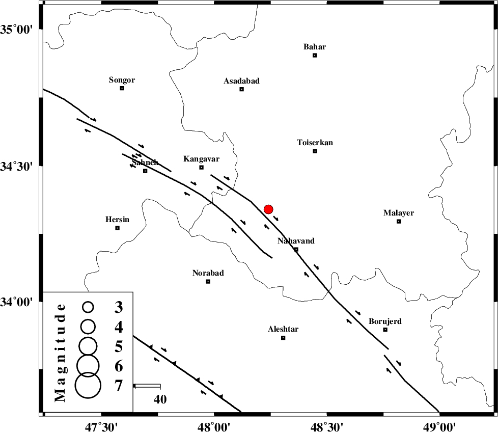
| Location | Lat:34.34 Lon: 48.24 |
| Region | Hamedan Province, 20 km North-West of Nahavand |
Nearest Cities |
|
| 8 km of Firuzan, Hamedan Province | |
| 11 km North of Shahrak, Hamedan Province | |
| 13 km North of Barzul, Hamedan Province | |
| 15 km North West of Dehghul, Hamedan Province | |
| 17 km South of Farsang, Hamedan Province | |
| Depth | 14 km |
| Agency | |
Faults within 150 km: |
|
| NAHAVAND_F (Length: 102 km) , Distance to epicenter: 8 km | |
| SAHANEH_F (Length: 77 km) , Distance to epicenter: 14 km | |
| DINEHVAR_F (Length: 46 km) , Distance to epicenter: 42 km | |
| Number of Phases | 4 |
| RMS | 0.1 |
| Number of Stations | 4 |
| Error in Latitude | >9.6 km |
| Error in Longitude | 6.7 km |
| Error in Depth | 7.4 km |
Download waveform in seisan format
to download seisan software Click here
to access information about IIEES stations Click here
Amplitude | ||||||||
| UID | Agency | Station | Component | Amplitude | Period | Arrival Time | Proccessing Time | Signal Clip |
| 78500 | IIEES | SNGE | N | 112.8 | 0.16 | 2011-03-31 07:05:10 | 2011-03-31 07:31:00 | n |
| 78501 | IIEES | SNGE | E | 107.8 | 0.25 | 2011-03-31 07:05:10 | 2011-03-31 07:31:00 | n |
| 78502 | IIEES | KHMZ | E | 45.9 | 0.64 | 2011-03-31 07:05:30 | 2011-03-31 07:31:00 | n |
| 78503 | IIEES | GHVR | N | 23.7 | 0.76 | 2011-03-31 07:05:59 | 2011-03-31 07:31:00 | n |
Phase | ||||||||||||
| Agency | Station | Component | Phase Type | Phase Quality | First Motion | Observed Arrival Time | Time Residual | Loc. Flag | Input Weight | Distance | Azimuth | |
| IIEES | SNGE | Z | Pg | E | 2011-03-31 07:04:53 | 0 | y | 117 | 316 | |||
| IIEES | ASAO | Z | Pg | E | 2011-03-31 07:05:01 | -0.1 | y | 166 | 81 | |||
| IIEES | KHMZ | Z | Pg | E | 2011-03-31 07:05:02 | -0.1 | y | 173 | 112 | |||
| IIEES | GHVR | Z | Pn | E | 2011-03-31 07:05:16 | 0.3 | y | 277 | 86 | |||