
Magnitude |
3.9 |
| Date & Time (UTC) | 2011-05-08 10:53:21.2 |
| Date & Time (Local) | 1390/2/18 15:23:21.2 |
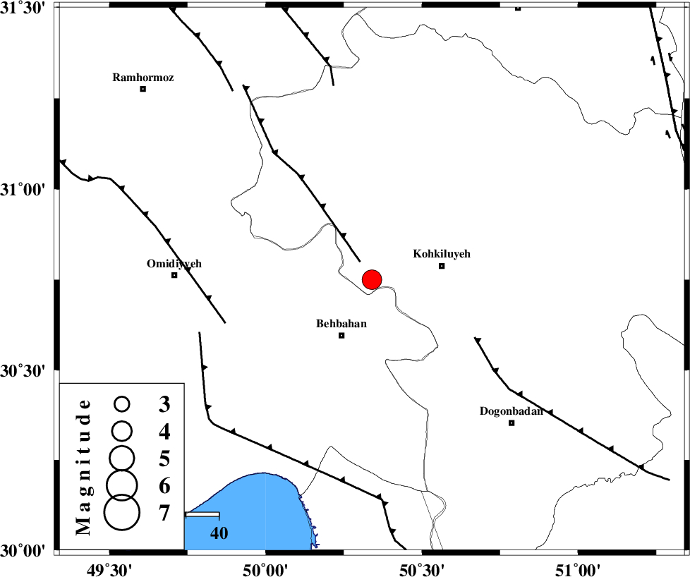
| Location | Lat:30.75 Lon: 50.34 |
| Region | Kohkiluieh va boyerahmad Province, 19 km North of Behbahan |
Nearest Cities |
|
| 14 km North of Mansuriyeh, Khoozestan Province | |
| 16 km North East of Dodange-ye bozorg, Khoozestan Province | |
| 19 km North of Behbahan, Khoozestan Province | |
| 22 km West of Dehdasht, Kohkiluieh va boyerahmad Province | |
| 27 km South of Lendeh, Kohkiluieh va boyerahmad Province | |
| Depth | 14 km |
| Agency | |
Faults within 150 km: |
|
| MFF4 (Length: 62 km) , Distance to epicenter: 6 km | |
| MISHAN_F (Length: 76 km) , Distance to epicenter: 36 km | |
| AGHAJARI_F (Length: 88 km) , Distance to epicenter: 47 km | |
| Number of Phases | 5 |
| RMS | 0 |
| Number of Stations | 6 |
| Error in Latitude | >2.1 km |
| Error in Longitude | 4.6 km |
| Error in Depth | 7.1 km |
Download waveform in seisan format
to download seisan software Click here
to access information about IIEES stations Click here
Amplitude | ||||||||
| UID | Agency | Station | Component | Amplitude | Period | Arrival Time | Proccessing Time | Signal Clip |
| 78893 | IIEES | GHIR | E | 223.4 | 0.43 | 2011-05-08 10:55:22 | 2011-05-08 11:26:00 | n |
| 78894 | IIEES | KRBR | N | 74.4 | 0.52 | 2011-05-08 10:55:50 | 2011-05-08 11:26:00 | n |
| 78895 | IIEES | KRBR | E | 43.9 | 0.37 | 2011-05-08 10:55:52 | 2011-05-08 11:26:00 | n |
Phase | ||||||||||||
| Agency | Station | Component | Phase Type | Phase Quality | First Motion | Observed Arrival Time | Time Residual | Loc. Flag | Input Weight | Distance | Azimuth | |
| IIEES | SHGR | Z | P | E | 2011-05-08 10:53:54 | 0 | y | 210 | 316 | |||
| IIEES | SHGR | E | Sg | E | 2011-05-08 10:54:20 | 0 | y | 210 | 316 | |||
| IIEES | AHRM | Z | P | E | 2011-05-08 10:53:57 | 0 | y | 228 | 156 | |||
| IIEES | KHMZ | Z | Pn | E | 2011-05-08 10:54:10 | 0.1 | y | 334 | 354 | |||
| IIEES | GHVR | Z | Pn | E | 2011-05-08 10:54:21 | -0.1 | y | 423 | 11 | |||